Colombia Earthquake History and Timeline
Colombia earthquake history verified: the August 2026 M7.4 Choco quake, 1868, 1979, 1983 Popayan, 1999 Armenia, tectonic setting, city risk and safety.
Latest Story
On the morning of 10 August 2026, a magnitude 7.4 earthquake tore through western Colombia. One month on, Colombia’s national disaster agency (UNGRD) put the confirmed toll at 321 dead as of 10 September 2026, while Wikipedia’s aggregated tracker cites 335+, collapsing airport terminals, hospital wards and a cathedral tower, and putting the country’s Colombia earthquake history back in the global spotlight. This is the strongest earthquake to strike Colombia in over a decade, and understanding it requires understanding what came before: the 1868 Colombia-Ecuador disaster, the 1979 Tumaco tsunami, the 1983 Popayán quake that rewrote the country’s building codes, and the 1999 Armenia earthquake that remains Colombia’s deadliest in living memory. This page tracks the 2026 Colombia earthquake as a live, changing event, and separately documents the full scientific and historical record behind why earthquakes in Colombia happen at all.
Casualty figures for a major earthquake change for days after the event, as search-and-rescue teams reach isolated areas and hospitals update records. Every number on this page tied to the 2026 earthquake carries the date and source it was reported by — treat any figure without that attribution as provisional. Historical earthquake data, particularly from the 19th century and earlier, carries its own uncertainty, which this page states explicitly rather than presenting invented precision.
🧠 Short Answer
A magnitude 7.4 earthquake struck western Colombia at 7:34 a.m. local time on 10 August 2026, centered near San José del Palmar in Chocó Department. It is Colombia’s strongest earthquake in over a decade. As of 10 September 2026, one month after the quake, Colombia’s national disaster agency (UNGRD) reports 321 confirmed dead and over 4,600 injured, while Wikipedia’s aggregated tracker cites 335+ dead and 111 still missing; a national disaster was declared and reconstruction is now under way across Chocó, Risaralda, Valle del Cauca and Caldas. Colombia sits atop a complex convergence of the Nazca, Caribbean and South American plates, which is why earthquakes here are frequent, historically destructive, and scientifically significant enough to include one of the world’s most unusual seismic phenomena, the Bucaramanga seismic nest.
Colombia Earthquake: Key Questions
What to Know About Colombia’s Earthquakes
- The August 2026 earthquake is Colombia’s strongest in over a decade. At Mw 7.4, it surpasses any single Colombian earthquake since at least the 2010s, though it is smaller than several historical megathrust events.
- The toll has largely settled one month on. As of 10 September 2026, Colombia’s national disaster agency (UNGRD) reports 321 dead, while aggregated trackers cite 335+ — the pace of new confirmations has slowed sharply since the first two weeks.
- Three tectonic plates, not one, drive Colombia’s seismicity. The Nazca, Caribbean and South American plates all interact beneath and around the country, alongside major crustal fault systems.
- Depth changes everything. The 1970 earthquake was larger (Mw 8.0) than 2026’s but caused little damage because it occurred 645 km underground; the shallow 1999 Armenia quake (17 km deep, Mw 6.2) was far more destructive despite being smaller.
- The Bucaramanga seismic nest is scientifically unique. It hosts the world’s highest concentration of intermediate-depth earthquakes in one place, a phenomenon researchers only partly understand.
- 1999 Armenia remains the deadliest modern, single-country Colombian earthquake. It also permanently changed how Colombia builds: pre-1984-code buildings collapsed at roughly 60%, post-code buildings mostly survived.
- Colombia’s earthquake building code (1984, updated as NSR-10) exists directly because of the 1983 Popayán earthquake. Regulation followed disaster, not the reverse.
- Bogotá’s risk isn’t about being near a fault — it’s about the ground itself. The city sits on a soft former-lakebed basin that can amplify shaking from earthquakes hundreds of kilometers away.
- No tsunami followed the 2026 earthquake, because its depth (96–110 km) was too great to displace the seafloor, despite occurring near Colombia’s Pacific coast.
- Aftershocks are ongoing and cannot be predicted individually. Dozens followed the 10 August mainshock; scientists can describe their statistical likelihood, not their timing or exact size.
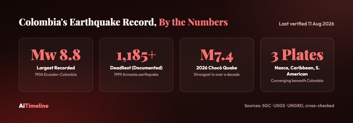
Colombia’s Earthquake Record, at a Glance
Largest, deadliest and most scientifically significant — three different rankings, not one. Full detail and sourcing follows below.
Magnitude Record
Deadliest, Documented
Current Event
What Happened? — Answer-First Summary
The 2026 earthquake in one paragraph, before the full case study further down this page.
At 7:34 a.m. local time (12:34 UTC) on Monday, 10 August 2026, a magnitude 7.4 earthquake struck approximately 20 km east of San José del Palmar in Colombia’s Chocó Department, at an intermediate depth of roughly 96–110 km. The shaking was felt across 32 departmental capitals and in neighboring Panama, Ecuador and Venezuela, reaching an estimated 34 million people, with around 10.5 million experiencing strong-to-very-strong shaking according to USGS modeling. It struck buildings, hospitals, schools and at least six airports across Chocó, Risaralda, Valle del Cauca, Caldas, Quindío and Antioquia. The passenger terminal at Pereira’s Matecaña International Airport partially collapsed; a wing of a children’s hospital in Cali came down; the bell tower of Manizales’ Metropolitan Cathedral Basilica — the tallest cathedral in Colombia — crumbled on camera. President Abelardo De La Espriella declared a national disaster within hours. As of 10 September 2026, one month after the quake, Colombia’s national disaster agency (UNGRD) reports 321 confirmed deaths and over 4,600 injured (aggregated trackers cite 335+ dead), with more than 1,300 aftershocks recorded and reconstruction now under way in the hardest-hit municipalities. The Pacific Tsunami Warning Center ruled out a tsunami, because the earthquake’s depth was too great to displace the seafloor.
Colombia Earthquake History — Quick Overview
Four centuries of documented seismicity, condensed.
Colombia’s earthquake record stretches back to Spanish colonial administrative records in the 1600s, though reliable magnitude estimates only become possible from the late 19th century onward, and truly instrumental data — recorded by seismographs rather than reconstructed from written accounts and damage patterns — only begins in the 20th century. The Servicio Geológico Colombiano (SGC) maintains a Historical Seismicity Information System covering significant earthquakes affecting Colombia since the 17th century, cross-referencing macroseismic intensity reports (how strongly shaking was felt at each location) against modern seismological reconstruction. This page treats that database, alongside USGS records for the instrumental era, as the primary source for every historical earthquake below.
The pattern across four centuries is consistent: Colombia’s most catastrophic earthquakes come from three distinct sources that behave very differently. Offshore Pacific subduction earthquakes (1906, 1979) are enormous but can be relatively survivable inland because their energy is spread over vast rupture areas and coastal populations are sparser — except where they trigger tsunamis. Shallow crustal earthquakes near populated Andean valleys (1983 Popayán, 1999 Armenia, 2008 Quetame) are usually smaller in magnitude but far more lethal per event, because the shaking is concentrated directly beneath cities built on unstable ground. And earthquake-triggered landslides in Colombia’s steep, rain-saturated terrain (1994 Páez) have killed more people than the shaking itself in at least one major disaster. The August 2026 earthquake combines elements of the first two categories: a large, intermediate-depth rupture whose damage was concentrated wherever population and vulnerable construction coincided with strong shaking.
Why Colombia Has Earthquakes
Three tectonic plates, one mountain range, and a country caught between all of them.
Colombia sits at one of the most tectonically complicated points on Earth: the convergence zone of the Nazca Plate, the Caribbean Plate and the South American Plate, further complicated by smaller crustal blocks (the North Andes and Panama microplates) squeezed between them. Along Colombia’s Pacific coast, the oceanic Nazca Plate is subducting — sliding beneath — the continental South American Plate at a rate of roughly 5.3 cm per year, in a broadly west-to-east direction. This subduction is not uniform: seismologists have identified a tear in the subducting slab near 5°N latitude, with a steeper subduction angle to the south and a shallower, flatter subduction segment to the north, which changes how earthquake energy is generated and released along different stretches of the coast.
To the north, the Caribbean Plate converges against Colombia at a shallow angle and a slower rate of roughly 1–2 cm per year, driving a different set of earthquakes beneath the Caribbean coast and northern Andes. Layered on top of both subduction systems is Colombia’s own internal crustal deformation: the collision and subduction processes have folded and fractured the Andes into multiple fault systems (detailed below) that generate their own shallow, often highly damaging earthquakes independent of the deeper subduction zones.
This three-way tectonic interaction produces earthquakes at every depth category scientists use: shallow earthquakes (roughly 0–70 km deep) along crustal faults, which tend to cause the most surface damage per unit of energy released; intermediate-depth earthquakes (roughly 70–300 km) associated with the subducting Nazca slab, including the unusual Bucaramanga seismic nest; and rarer deep-focus earthquakes (below 300 km, exceptionally down to 645 km in Colombia’s case) generated within the deeper, still-descending remnants of subducted oceanic plate.
Colombia’s Tectonic Setting
Nazca Plate
Subducts beneath South America along Colombia’s Pacific coast at ~5.3 cm/yr. Drives the Chocó, Nariño and Valle del Cauca subduction earthquakes, including the 1906, 1979 and 2026 events.
Caribbean Plate
Converges against northern Colombia at a shallow angle, ~1–2 cm/yr. A distinct seismic source from the Pacific subduction system, contributing to Caribbean-coast and northern Andes seismicity.
South American Plate
The plate Colombia sits on. Its own westward motion and internal crustal fracturing, layered on top of subduction from both oceanic plates, produces the shallow Andean fault-system earthquakes.
Northern Andes
Formed and continuously deformed by this plate convergence, split into three parallel ranges (Cordilleras) across Colombia, each riddled with active fault systems.
Researchers studying the region describe a subduction “slab tear” near 5°N latitude, separating a steeper subduction segment to the south from a flatter one to the north — a detail that matters because subduction angle affects where and how earthquake energy accumulates and releases along the Pacific margin.
Colombia’s Major Fault Systems
Only faults with documented seismicity in the scientific literature are listed here.
Romeral Fault System
Location: Runs roughly 700 km through the Western and Central Cordilleras, from about 1°N to 8°N. Type: An old, deformed shear zone marking a former subduction boundary between oceanic and continental crust. Significance: One of Colombia’s most active and continuous fault systems. Nearby cities: Cali, Medellín, Popayán, Manizales lie near or along its trace.
Magdalena Valley Fault System
Location: Follows the Magdalena River valley between the Central and Eastern Cordilleras. Significance: One of Colombia’s three main active fault systems identified in seismotectonic studies, generating shallow crustal earthquakes along central Colombia.
Eastern Cordillera Frontal Fault System
Location: Along the eastern edge of the Eastern Cordillera, bordering the Llanos foothills. Significance: Associated with damaging shallow earthquakes near Bogotá, including the 2008 Quetame/El Calvario earthquake and historical events affecting the capital region.
Algeciras Fault
Location: Huila Department, southwestern Colombia. Significance: A major active strike-slip fault in the region where the destructive 1967 Huila (Neiva) earthquake occurred, one of Colombia’s largest documented crustal earthquakes.
These are the best-documented systems in peer-reviewed seismotectonic literature; Colombia’s full fault inventory is considerably larger; smaller local faults contribute to hazard in specific regions but lack the same volume of published seismic-history data as the systems above.
The Bucaramanga Seismic Nest
One of the strangest, most concentrated earthquake phenomena on Earth — and it sits beneath a Colombian city.
Beneath the city of Bucaramanga, at a depth of roughly 150–170 km, lies the Bucaramanga seismic nest — the highest concentration by volume of intermediate-depth earthquakes anywhere in the world. Unlike a normal fault that ruptures along a two-dimensional plane, the nest is a compact three-dimensional cluster where small-to-moderate earthquakes occur constantly, day after day, packed into an unusually small volume of subducting oceanic slab beneath the Andes.
Scientifically, the nest is puzzling because standard rock physics says it shouldn’t exist: at 150+ km depth, temperature and pressure conditions are normally expected to make rock deform plastically (bending and flowing) rather than fracture suddenly (the “brittle failure” that causes earthquakes). A 2023 study published in Scientific Reports proposed that the nest actually has two distinct causes layered on top of each other: an upper cluster around 130 km depth driven by dehydration embrittlement (water trapped in the subducting slab’s minerals being released under heat and pressure, weakening the rock), and a lower cluster around 150 km depth linked to lithospheric delamination — a dense “drip” of material peeling away from the base of the plate and sinking, which squeezes fluids out of the subducting slab and may trigger additional seismicity.
For seismologists, the Bucaramanga nest functions as a natural laboratory: nowhere else on Earth produces this volume of intermediate-depth earthquake data in one place, making it one of the best-studied sites for understanding how and why earthquakes happen at depths where they theoretically shouldn’t. For residents of Bucaramanga, the practical effect is a city that experiences frequent, usually minor, felt tremors — among the highest felt-earthquake frequencies of any city in the world — without most of them producing significant surface damage, because the shaking originates so far underground.
Magnitude vs Intensity: What Is the Difference?
Magnitude measures the total energy released at an earthquake’s source — a single number for the whole event, regardless of where you are standing. Intensity describes how strongly the ground actually shook, and how much damage resulted, at one specific location — and it varies enormously depending on distance from the epicenter, depth, local soil conditions and building type.
A simple example: the 2026 Chocó earthquake (Mw 7.4) and the 1970 Amazonas earthquake (Mw 8.0) were both very large by magnitude. But the 1970 quake occurred 645 km underground and caused minimal surface damage anywhere, despite being felt from Bogotá to Buenos Aires — low intensity everywhere, spread across a huge area, because the energy had so much rock to travel through before reaching the surface. The 1999 Armenia earthquake, by contrast, was a comparatively modest Mw 6.2 — but at just 17 km deep and centered almost directly beneath a city built partly on unstable ground, it produced Modified Mercalli Intensity of X (extreme) in Armenia itself: catastrophic local intensity from a moderate-magnitude event.
| Concept | Measures | Varies by location? | Example scale |
|---|---|---|---|
| Magnitude | Total energy released at the source | No — one number per earthquake | Moment magnitude (Mw), Richter/local (ML), surface-wave (Ms), body-wave (Mb) |
| Intensity | Shaking strength and damage felt at a specific place | Yes — different at every location | Modified Mercalli Intensity (MMI, I–XII) |
Is Colombia on the Ring of Fire?
Partly, and the nuance matters. The Pacific Ring of Fire is a roughly horseshoe-shaped belt of subduction zones and volcanoes circling the Pacific Ocean basin, along which the USGS estimates around 90% of the world’s earthquakes and three-quarters of its active volcanoes occur. Colombia’s Pacific coast — Chocó, Nariño and part of Valle del Cauca — sits directly within this belt, because the Nazca Plate’s subduction beneath South America there is the same kind of process that defines the Ring of Fire everywhere else along its length, from Japan to Chile.
But “Colombia is on the Ring of Fire” is an oversimplification if applied to the whole country. Colombia’s seismicity also comes from sources the Ring of Fire framing doesn’t capture: the Caribbean Plate’s separate convergence against northern Colombia, the internal crustal fault systems cutting through the Andes (Romeral, Magdalena Valley, Eastern Cordillera Frontal) that generate earthquakes independent of any subduction zone, and the deep, geologically unusual Bucaramanga seismic nest. A geologist would more precisely say Colombia’s Pacific-Andean zone lies within the Ring of Fire’s mechanism, while the country’s overall seismic hazard is the product of at least three distinct tectonic processes operating simultaneously — which is also why Colombia’s earthquakes vary so much in depth, mechanism and the regions they affect.
Earthquake Science, Explained Simply
Fault
A fracture in Earth’s crust where rock on either side has moved relative to the other. Earthquakes happen when stress built up along a fault is suddenly released.
Epicenter
The point on Earth’s surface directly above where an earthquake begins underground. It’s what maps show, but it isn’t where the rupture actually occurs.
Hypocenter (Focus)
The actual underground point where an earthquake’s rupture begins. The 2026 earthquake’s hypocenter was ~96–110 km below its epicenter near San José del Palmar.
Aftershock
A smaller earthquake that follows a larger “mainshock” in the same area, caused by the crust readjusting to the stress change the mainshock created.
Foreshock
A smaller earthquake that precedes a larger one in the same area — only identifiable as a “foreshock” in hindsight, after the larger quake happens.
Seismic Wave
The energy released by an earthquake, traveling through Earth as several distinct wave types, each moving at different speeds.
P-wave
“Primary” wave — the fastest seismic wave, compressing and expanding rock like sound through air. Arrives first, usually felt as a sharp jolt.
S-wave
“Secondary” wave — slower than P-waves, moves rock side-to-side. Arrives after the P-wave and typically causes stronger shaking.
Surface Wave
Slower still, travels along Earth’s surface rather than through its interior. Usually responsible for the most severe shaking and damage in shallow earthquakes.
Subduction
The process where one tectonic plate slides beneath another. Along Colombia’s Pacific coast, the Nazca Plate subducts beneath the South American Plate.
Liquefaction
When violent shaking causes water-saturated, loose soil to temporarily behave like a liquid, losing its ability to support buildings above it — a major cause of structural collapse on soft ground.
Intensity vs Magnitude
See the dedicated section above — magnitude is one number per earthquake; intensity changes by location.
Colombia Earthquake Timeline
Reverse chronological, 17th century to 2026. Sourced from the SGC Historical Seismicity Information System and USGS records; magnitude type is noted where it differs from modern Mw.
One month on: toll settles near 321, reconstruction decrees enacted
Colombia’s national disaster agency reported 321 confirmed deaths one month after the mainshock, with more than 1,300 aftershocks recorded since 10 August. The government enacted eleven decrees to fund recovery, including the Fondo Patria Milagro reconstruction fund, tax incentives for rebuilding and authorization for affected municipalities to draw on territorial pension reserves. A UN/UNDP-UNGRD assessment put total damage at roughly 42.1 trillion pesos (about US$13.4 billion, 2.3% of GDP).
Death toll passes 180 as search hits critical time window
Two days after the mainshock, rescuers pushed against the survival time threshold for locating people alive in collapsed buildings. 54+ aftershocks recorded since 10 August; 1,000+ soldiers deployed to Cali for public order and curfews enforced in Cali and Pereira.
M7.4 earthquake strikes Chocó Department
Colombia’s strongest earthquake in over a decade. Full case study further down this page.
Quetame / El Calvario earthquake
11 deaths, 4,181 injured, per Wikipedia’s cross-referenced USGS-sourced record. Damaged buildings as far as central Bogotá, ~50 km from the epicenter.
Armenia earthquake (Eje Cafetero)
Colombia’s deadliest modern, single-country earthquake. Official DANE figure: 1,185 dead; widely cited aggregate estimate: ~1,900. Full case study below.
Páez River earthquake and avalanche
~1,100 deaths, most from an earthquake-triggered mudslide/debris avalanche down the Páez River that buried indigenous Nasa communities — not from the shaking itself.
Popayán earthquake
267 killed (some sources cite ~300), 7,500 injured. Directly led to Colombia’s first seismic building code in 1984. Full case study below.
Tumaco earthquake and tsunami
An estimated 300–600 deaths, most from a tsunami reaching 6 meters that struck the Colombia-Ecuador Pacific coast within minutes. Part of a rupture sequence with 1942 and 1958 earthquakes on the same megathrust.
Deep-focus Colombia earthquake
Among the largest deep-focus earthquakes ever recorded, until surpassed by a 1994 Bolivia event. Felt from Bogotá to Buenos Aires and São Paulo, but caused minimal damage anywhere due to its extreme depth — a textbook illustration of why depth matters more than magnitude alone.
Huila (Neiva) earthquake
Colombia’s largest documented crustal (non-subduction) earthquake. 98 deaths, over 350 aftershocks recorded. Widely felt in Bogotá and across southern Colombia. A separate, smaller Aratoca earthquake (Mw 6.8) also struck Colombia in 1967.
Tolima earthquake
Documentation for this event is sparse compared to later 20th-century earthquakes; the magnitude is a historical-catalog estimate, not an instrumental reading.
Sumapaz / Acacías earthquake
The most damaging earthquake to affect Bogotá in the historical record, producing an estimated Modified Mercalli Intensity of VIII in the capital, though only 6 deaths were documented — a reflection of how sparsely populated the affected Eastern Cordillera region was at the time, not of how strong the shaking was. No comparably large earthquake has struck this close to Bogotá since.
Ecuador-Colombia offshore megathrust earthquake
One of the largest earthquakes ever recorded anywhere on Earth. Generated a Pacific-wide tsunami with waves up to 5 meters; an estimated 1,000 deaths across the affected region. Its rupture zone was later partially re-ruptured in segments by the 1942, 1958 and 1979 earthquakes.
Cúcuta earthquake
An estimated 10,000 deaths across the Cúcuta region, at Modified Mercalli Intensity IX — among the deadliest earthquakes documented on Colombian soil specifically (as distinct from the binational 1868 event below). Historical death tolls from this era carry substantial uncertainty given limited record-keeping.
Colombia-Ecuador border earthquakes
Two earthquakes in as many days devastated the Ecuador-Colombia frontier region. Combined casualty estimates as high as 70,000 appear in historical sources, but this figure spans both countries and predates any systematic census-based verification — it should be read as a widely cited historical estimate, not a precise count. Full uncertainty discussion below.
Timaná earthquake
Approximately 250 deaths at Modified Mercalli Intensity X, per SGC historical reconstruction — one of the most severe intensities documented for any Colombian earthquake, colonial-era or modern.
La Calera earthquake
9 documented deaths. Notable for an unusual historical footnote: colonial-era news coverage of this earthquake is credited by some historians as an early spark for the birth of journalism in Colombia.
Earliest documented colonial-era earthquakes
The SGC’s Historical Seismicity Information System traces documented earthquake accounts affecting Colombia back to the 1600s, though these earliest records rely on written damage descriptions rather than any instrumental measurement, and magnitude figures for this era are reconstructions, not measurements.
📋 A Note on Historical Uncertainty
For any earthquake before the mid-20th century, “magnitude” on this page means a reconstructed estimate derived from written damage accounts and intensity mapping, not an instrumental measurement — seismographs capable of reliably recording distant large earthquakes only became widespread in the 20th century. Casualty figures for 19th-century and earlier events are similarly reconstructions from historical records, which were often incomplete, especially in rural and indigenous communities. Where sources disagree meaningfully (1868, 1875, 1979, 1983, 1999), this page states the range and identifies which source reports which figure, rather than picking one number and presenting it as settled fact.
The 1868 Colombia-Ecuador Earthquakes
The region’s most severe historical binational disaster — and its casualty figures are the least certain on this page.
On 15 and 16 August 1868, two major earthquakes struck within a day of each other along the Ecuador-Colombia border. The first, on 15 August, was centered near El Ángel in Ecuador’s Carchi Province, close to the Colombian frontier; the second, on 16 August, struck near Ibarra in Ecuador’s Imbabura Province. Historical sources estimate their magnitudes at roughly M6.3 and M6.7 respectively, though at least one source places one event as high as an estimated M7.7 — a wide range typical of pre-instrumental earthquakes, where magnitude has to be reconstructed from written damage descriptions rather than measured directly.
Why the death toll is uncertain: Widely cited historical sources put combined casualties from the two earthquakes as high as 70,000 across the affected Ecuador-Colombia border region. This figure predates any national census-based verification, spans two countries rather than Colombia alone, and originates from 19th-century accounts compiled well before modern demographic or forensic methods existed. Modern seismological and historical scholarship treats it as a widely repeated historical estimate rather than a confirmed count. This page states it as such: a historical estimate, not a verified statistic, and one that describes a binational disaster rather than a Colombia-only death toll.
Impact: Severe damage was documented across northeastern Ecuador and southwestern Colombia, making the 1868 events among the most destructive earthquakes to affect the Colombia-Ecuador border region in the historical record, alongside the earlier-documented 1875 Cúcuta earthquake, which struck Colombian territory specifically and is separately covered in the timeline above.
1983 Popayán Earthquake
A moderate-magnitude, shallow earthquake that killed hundreds and rewrote Colombia’s building codes.
At 8:13 a.m. on 31 March 1983 — Maundy Thursday, one of the most heavily attended days of Colombia’s Holy Week observances — a shallow earthquake struck southwest of Popayán, capital of Cauca Department. Sources differ slightly on the exact magnitude (5.6 Mw versus 5.5 ML depending on the catalog), but agree it was a moderate-sized, very shallow event at roughly 15 km depth, shaking for 18 to 28 seconds.
The human toll was severe for an earthquake of this size: 267 people killed (some secondary sources cite figures closer to 300) and roughly 7,500 injured. The damage reflected decades of unreinforced colonial and early-20th-century masonry construction in Popayán’s historic center: of roughly 14,000 buildings affected, 6,885 suffered damage exceeding 50% of their structure, and 2,470 houses collapsed outright. Popayán, founded in 1537, had already been destroyed on three previous occasions by earthquakes and volcanic eruptions before 1983 — a repeating pattern the city’s rebuilding had never fully addressed until this disaster.
The lasting legacy is regulatory, not just architectural. The Popayán earthquake directly prompted Colombia’s first national seismic building code, enacted in 1984, initially focused on small residential dwellings. It also led to the formal establishment of the Colombian Seismic Network for nationwide earthquake monitoring. International reconstruction assistance included aid from Spain, Venezuela and the United States (~$700,000 in supplies), plus an $80 million World Bank credit line for broader recovery. The lesson Colombian engineers drew from Popayán — that unreinforced masonry fails catastrophically even in moderate shaking — became the founding principle behind every seismic code Colombia has adopted since.
1994 Páez River Earthquake and Avalanche
A case where the earthquake itself was survivable — but what it triggered wasn’t.
On 6 June 1994, a magnitude 6.8 earthquake struck at just 12 km depth near the Nevado del Huila volcano, in the Tierradentro region of Cauca Department, on the border with Huila. The shaking itself, while damaging, was not the primary killer. The earthquake violently destabilized the steep, rain-saturated slopes above the Páez River valley, triggering a massive avalanche of mud, rock and water that swept downstream, burying entire settlements.
An estimated 1,100 people were killed, the overwhelming majority from the debris avalanche rather than building collapse from shaking. Most victims were members of the indigenous Nasa community, living in some 15 settlements along the Páez River basin across Cauca and Huila departments; the town of Páez itself absorbed roughly half the total death toll. The villages of Toez and Irlanda were swept away entirely by the mudslide. The disaster remains one of the clearest illustrations in Colombian history of earthquake-triggered secondary hazards — specifically landslides and debris flows — killing far more people than ground shaking alone, a pattern discussed further in the Landslides section below.
1999 Armenia Earthquake
Colombia’s deadliest modern, single-country earthquake — and the disaster that permanently changed how the country builds.
At 1:19 p.m. local time on 25 January 1999, a magnitude 6.2 earthquake struck at a shallow depth of 17 km, roughly 40 km west-southwest of Ibagué, with its most severe impact centered on Armenia, capital of Quindío Department, in Colombia’s coffee-growing region (the Eje Cafetero). Around 18 additional towns and 28 rural villages across the region were also affected, along with lesser damage in Pereira and Manizales.
Casualties and the discrepancy in death-toll figures: Colombia’s National Administrative Department of Statistics (DANE) recorded 1,185 confirmed deaths, the figure most frequently cited as the official government count. Other contemporaneous and aggregated sources, including widely referenced encyclopedic tallies, report figures closer to 1,900 dead, alongside roughly 4,000 injured and as many as 3,900 initially reported missing. The gap between these numbers has a documented explanation: many bodies could not be identified and were buried in common graves, road and communications collapse hampered rescue coordination in the disaster’s early days, and subsequent unrest complicated final accounting. This page reports both figures with their respective sources rather than treating either as the single definitive count.
The building-code lesson, verified. Roughly 60% of Armenia’s existing poorly engineered structures collapsed. Critically, buildings constructed after Colombia’s 1984 seismic code took effect performed dramatically better, surviving largely intact — a real-world, side-by-side demonstration of what the 1983 Popayán-driven code reform was designed to achieve, fifteen years after it was written.
Economic and social impact: Roughly 8,000 coffee farms were completely or partially destroyed and 13,000 commercial and industrial structures were damaged, striking at the heart of Colombia’s coffee-export economy. Banks in the region could not dispense cash for several weeks. Reconstruction was coordinated through Colombia’s Fondo para la Reconstrucción del Eje Cafetero (FOREC); one resettlement community, El Cantaro, wasn’t completed until January 2002, three years after the earthquake, ultimately housing 125 of the neediest displaced families. The 1999 Armenia earthquake remains the reference disaster Colombian emergency planners and engineers cite most often when discussing seismic risk — the clearest domestic proof that building codes save lives, and that reconstruction timelines are measured in years, not months.
2008 Quetame Earthquake
A reminder that Bogotá’s earthquake risk isn’t hypothetical — it happened recently, and it was close.
At 2:20 p.m. local time on 24 May 2008, a magnitude 5.9 earthquake struck near El Calvario, Meta Department, at roughly 35 km depth — about 35 km from Villavicencio and 50 km from Bogotá. A smaller M4 foreshock had occurred roughly two hours earlier near San Juanito. The earthquake affected the municipalities of Quetame, Puente Quetame, Fosca, Fómeque, Guayabetal and El Calvario across the Cundinamarca-Meta border, with shaking reaching Maximum Mercalli Intensity VII (Very Strong).
11 people were killed and 4,181 were injured, with multiple house collapses in Quetame (population roughly 6,500) and partial collapse of the Lotería de Bogotá building in the capital itself, despite the epicenter being 50 km away. Two kilometers of Highway 48 closed under fallen debris, and reconstruction was estimated at $10 million. The Quetame earthquake is one of the most recent examples of a shallow crustal earthquake near the Eastern Cordillera Frontal Fault System causing real, if contained, damage in Bogotá — the clearest modern precedent for the “distant earthquakes can still damage the capital” discussion in the Bogotá risk section below.
The 2026 Colombia Earthquake
The largest section on this page, because it’s the least settled. Every figure below is dated. Do not treat any casualty number here as final.
What happened? At 7:34:28 a.m. COT (12:34:28 UTC) on Monday, 10 August 2026, a magnitude 7.4 earthquake ruptured at intermediate depth beneath Chocó Department, in Colombia’s underdeveloped western Pacific lowlands. The rupture mechanism, per USGS analysis, was strike-slip faulting — horizontal sliding along either a northeast-trending left-lateral fault or a northwest-trending right-lateral fault; seismologists have not yet publicly resolved which orientation is correct, which is normal in the days immediately following a large earthquake.
Where was the epicenter? Approximately 20 km east of San José del Palmar, a small municipality in Chocó, at coordinates near 4.90°N, 76.19°W — roughly 280 km west of Bogotá. This is a sparsely populated, mountainous, historically underdeveloped part of Colombia, which shaped both the disaster’s early information gaps (poor road and communications infrastructure slowed initial damage assessment) and its regional spread (the nearest large cities — Quibdó, Pereira, Cali, Manizales — are all significant population centers within 100–250 km).
How strong was it, and why so widely felt? At Mw 7.4, this is Colombia’s strongest earthquake in over a decade. Its intermediate depth (96 km per the Servicio Geológico Colombiano; 110.3 km per USGS — the two agencies’ models differ slightly, which is normal for depth estimates on the same event) meant the shaking radiated outward across a very wide area rather than concentrating destructively at a single point, similar in principle to the pattern seen in the 1970 deep-focus event, though far shallower and far more damaging. Shaking was reported in 32 Colombian departmental capitals and felt in neighboring Panama, Ecuador and Venezuela. USGS population-exposure modeling estimated approximately 34 million people experienced some level of shaking, with roughly 10.5 million experiencing strong-to-very-strong intensity.
Which regions were affected, and what was damaged? The heaviest damage was concentrated in Chocó (at and near the epicenter), Risaralda (Pereira), Valle del Cauca (Cali), Caldas (Manizales) and Quindío (Armenia), with meaningful damage also reported in Antioquia. In San José del Palmar, at least 20 buildings collapsed completely and around 400 homes were damaged. In Quibdó, Chocó’s departmental capital, 8 deaths and 42 collapsed structures were reported. In Pereira, 60 deaths and more than 65 building collapses were reported, alongside the partial collapse of the passenger terminal at Matecaña International Airport, which suspended airport operations pending structural assessment. In Cali, a city of roughly 2 million people, at least 19 buildings collapsed with people trapped inside according to Mayor Alejandro Eder, including the collapse of pediatric and neonatal hospital sections; citywide, 18 hospitals sustained damage and more than 5,000 buildings were damaged or destroyed. In Manizales, the bell tower of the Metropolitan Cathedral Basilica — Colombia’s tallest cathedral — partially collapsed on video, alongside 36 other collapsed structures and 4 deaths. At least six airports (Pereira, Manizales, Quibdó, Armenia, Cartago and Buenaventura) suffered damage; Popayán’s airport was separately closed the same period for volcanic ash, unrelated to the earthquake.
What are authorities reporting, and what remains uncertain? President Abelardo De La Espriella declared a national disaster within hours, enabling coordinated mobilization of emergency resources, and established a Unified Command Post to direct the response. Colombia’s National Unit for Disaster Risk Management (UNGRD) confirmed no tsunami threat. At least 54 aftershocks have been recorded since the mainshock, the largest an mb 5.0 event roughly 44 minutes after it struck. As of 12 August 2026, two days after the mainshock, casualty figures were still in active flux: Colombian government officials reported at least 181 confirmed deaths, 2,595+ injured and 195 people officially listed missing, while aggregated reference trackers (including Wikipedia’s continuously updated entry) cited a higher running total of 254+ deaths and civilian-run missing-persons databases listed 4,130+ people unaccounted for. By the one-month mark on 10 September 2026, the toll had largely settled: UNGRD reported 321 confirmed dead and 4,600+ injured, aggregated trackers cited 335+ dead, and the missing-persons count had fallen to 111. NPR reported on 12 August that rescue teams were pushing up against the survival time threshold for finding people alive in the rubble, straining Colombia’s response as the search increasingly shifts toward recovery.
Rescue operations: Search-and-rescue teams, supported by the Colombian military, were deployed to the hardest-hit municipalities within hours; by 12 August, 220+ rescue specialists and 100 military engineers were working the disaster zone, with at least 38 people pulled alive from rubble in Cali. Roughly 1,000 additional soldiers were deployed to Cali to maintain public order, and curfews were enforced in Cali and Pereira. International assistance included a 47-member search-and-rescue team from Ecuador, $15.5 million in relief funding pledged by the United States, 100 tons of humanitarian aid pledged by El Salvador, and activation of the European Union’s Copernicus satellite mapping programme to help direct response efforts using rapid damage-assessment imagery.
How does it compare with historical Colombian earthquakes? At Mw 7.4, the 2026 earthquake is smaller in raw magnitude than the 1906 (Mw 8.8), 1970 (Mw 8.0) and 1979 (Mw 8.2) events, but it is shallower than 1970 and closer to population centers than either 1906 or 1979’s offshore epicenters, which is why its human toll, now largely settled at 321+ confirmed dead one month on, has already exceeded the 2008 Quetame disaster many times over. It has not approached the confirmed death tolls of the 1994 Páez (~1,100) or 1999 Armenia (1,185+) disasters. See the direct comparison table below.
⚠️ Live Data Warning
Figures in this section are updated through 10 September 2026, the one-month mark. Death tolls, injury counts, missing-persons figures and building-damage estimates moved quickly in the first two weeks after the quake and have since slowed as rescue shifted to reconstruction. Treat this section as a snapshot, not a final record, and check the Servicio Geológico Colombiano, USGS and UNGRD directly for the most current figures.
2026 Earthquake vs Historical Events
Status column marks whether each figure is preliminary, verified or a historical estimate.
| Event | Year | Magnitude | Depth | Epicenter | Deaths | Status |
|---|---|---|---|---|---|---|
| 2026 Chocó | 2026 | Mw 7.4 | 96–110 km | San José del Palmar, Chocó | 321+ (aggregated trackers: 335+) | Largely settled, one month on |
| 1906 Ecuador-Colombia | 1906 | Mw 8.8 | Shallow, offshore | Ecuador-Colombia border | ~1,000 | ESTIMATED (historical) |
| 1979 Tumaco | 1979 | Mw 8.2 / Ms 8.1 | 33 km | Offshore Nariño | 300–600 | ESTIMATED (sources vary) |
| 1970 Amazonas | 1970 | Mw 8.0 | 645 km | Amazonas region | Minimal (deep-focus) | VERIFIED (instrumental) |
| 1999 Armenia | 1999 | Mw 6.2 | 17 km | Near Ibagué / Armenia, Quindío | 1,185 (DANE) – ~1,900 (aggregate) | VERIFIED, range documented |
| 1994 Páez | 1994 | Mw 6.8 | 12 km | Tierradentro, Cauca | ~1,100 (mostly avalanche) | VERIFIED (instrumental) |
| 1983 Popayán | 1983 | Mw 5.6 / ML 5.5 | 15 km | Southwest of Popayán, Cauca | 267 (some sources: ~300) | VERIFIED, minor range |
| 1967 Huila (Neiva) | 1967 | Mw 7.0–7.2 | 55 km | Caquetá/Huila border | 98 | VERIFIED (instrumental) |
| 2008 Quetame | 2008 | Mw 5.9 | 35 km | El Calvario, Meta | 11 | VERIFIED (instrumental) |
| 1868 Ecuador-Colombia | 1868 | M6.3–7.7 (two events) | Unknown | Carchi/Imbabura, Ecuador & SW Colombia | Up to ~70,000 (binational) | ESTIMATED (historical, high uncertainty) |
📋 Source note for this table
2026 figures: Servicio Geológico Colombiano, USGS, UNGRD, Wikipedia aggregated tracker, as of 10 September 2026. Historical figures: USGS, SGC Historical Seismicity Information System, and the individually cited sources in each earthquake’s own section above.
Largest Earthquakes Affecting Colombia
Ranked strictly by magnitude — not the same list as “deadliest” or “most destructive” below.
| Rank | Event | Magnitude | Year |
|---|---|---|---|
| 1 | Ecuador-Colombia offshore | Mw 8.8 | 1906 |
| 2 | Tumaco | Mw 8.2 / Ms 8.1 | 1979 |
| 3 | Amazonas (deep-focus) | Mw 8.0 | 1970 |
| 4 | Chocó (San José del Palmar) | Mw 7.4 | 2026 |
| 5 | Huila (Neiva) | Mw 7.0–7.2 | 1967 |
| 6 | Sumapaz / Acacías | Ms 7.1–7.3 | 1917 |
| 7 | Cúcuta | ~M7.5 (est.) | 1875 |
| 8 | Timaná | ~Ms 7.7 (est.) | 1827 |
Magnitude alone doesn’t predict human impact: the two largest earthquakes on this list (1906, 1970) caused comparatively limited direct casualties — 1906 because its energy dissipated across a huge offshore rupture and 1970 because it occurred 645 km underground — while several smaller-magnitude events below caused far more deaths, covered next.
Deadliest Earthquakes Associated With Colombia
“Deadliest in Colombia” and “deadliest Colombia-Ecuador regional event” are different questions — this table separates them.
| Event | Deaths | Scope | Certainty |
|---|---|---|---|
| 1868 Ecuador-Colombia earthquakes | Up to ~70,000 | Binational (Ecuador + SW Colombia) | Historical estimate, high uncertainty |
| 1875 Cúcuta earthquake | ~10,000 | Colombia (Norte de Santander) | Historical estimate |
| 1999 Armenia earthquake | 1,185 (DANE) – ~1,900 (aggregate) | Colombia (Quindío / Eje Cafetero) | Documented, range explained above |
| 1994 Páez earthquake & avalanche | ~1,100 | Colombia (Cauca/Huila) — mostly landslide deaths | Documented |
| 1906 Ecuador-Colombia offshore | ~1,000 | Binational, tsunami-driven | Historical estimate |
| 2026 Chocó earthquake | 321+ (aggregated trackers: 335+) | Colombia (multi-department) | Largely settled, one month on |
| 1979 Tumaco earthquake & tsunami | 300–600 | Colombia + Ecuador coast | Estimated, sources vary |
| 1983 Popayán earthquake | 267 (some sources: ~300) | Colombia (Cauca) | Documented |
The single most important distinction on this page: the 1868 and 1906 tolls describe a binational Ecuador-Colombia disaster zone, not deaths within Colombia’s present-day borders alone. Colombia’s deadliest well-documented, single-country modern earthquake is 1999 Armenia. Its deadliest earthquake by any measure, if the historical 1868/1875 estimates are accepted as reported, predates modern Colombia’s institutional record-keeping entirely.
Most Destructive Earthquakes
Ranked by combined human, structural and economic disruption, where reliable data exists. Historical economic losses are not adjusted to modern dollar equivalents, since no consistent conversion methodology is available across a 150-year span.
1999 Armenia
1,185+ deaths, ~13,000 damaged commercial structures, 8,000 coffee farms destroyed, multi-year FOREC-led reconstruction. The clearest case of an earthquake reshaping national policy and economy simultaneously.
1983 Popayán
~14,000 buildings damaged, ~$50 million in direct damage, and Colombia’s first seismic building code passed the following year as a direct result.
1994 Páez
Entire villages erased by an earthquake-triggered avalanche rather than shaking — a different kind of destructiveness, measured in displaced indigenous communities rather than collapsed city blocks.
2026 Chocó
1,600+ buildings damaged in initial reports, rising toward 5,000+ homes; 6+ airports affected; multiple hospitals damaged in Cali alone. Final destructiveness ranking will depend on figures still being confirmed.
Bogotá Earthquake Risk
Colombia’s capital has no recent history of a major damaging quake directly beneath it — but that is not the same as being safe.
Could Bogotá experience a major earthquake? Yes. No credible seismological source describes any Colombian city as immune to earthquake risk, and Bogotá’s own historical record includes four earthquakes — 1743, 1785, 1826 and 1917 — that produced Modified Mercalli Intensity VIII (severe) shaking in the city. No comparably large, close earthquake has struck Bogotá since 1917, which some seismologists note as a long quiet interval worth monitoring rather than a guarantee of continued calm.
What makes Bogotá’s risk unusual is its geology, not just nearby faults. The city sits on the Sabana de Bogotá, a high Andean plateau (2,640 m elevation) that was, in prior geological eras, the bed of a large lake. The soft, water-saturated lacustrine sediment filling this basin can amplify seismic shaking significantly compared to solid bedrock — the same basin-amplification mechanism that made Mexico City’s 1985 earthquake so much more destructive in the city than at its Pacific coast epicenter, hundreds of kilometers away. This is why the August 2026 earthquake, centered roughly 280 km from Bogotá, was still felt clearly in the capital: intermediate-depth, high-magnitude earthquakes plus basin amplification can transmit noticeable shaking across very large distances.
Which faults matter for Bogotá? The nearest significant source of shallow, potentially damaging earthquakes is the Eastern Cordillera Frontal Fault System, along the Llanos foothills southeast of the city — the same general zone that produced the 2008 Quetame/El Calvario earthquake, which partially damaged a building in central Bogotá from 50 km away.
What residents should know: Bogotá’s earthquake risk comes from two combined factors that don’t require a fault directly under the city: a nearby active fault system capable of shallow, damaging ruptures, and a soft sedimentary basin that can amplify shaking from both nearby and distant earthquakes. Building-code compliance (see NSR-10 section below) and knowing safe indoor locations (see Earthquake Preparedness below) matter in Bogotá exactly as they do in any seismically active city, regardless of the years since the last major local event.
City-by-City Earthquake Risk
No Colombian city is “safe” from earthquakes. Risk profiles differ by proximity to faults, subduction geometry, soil conditions and construction age.
Medellín
Near the Romeral Fault System’s trace through the Central and Western Cordilleras. Documentedly affected in the August 2026 earthquake, with Antioquia department reporting 350+ damaged homes, 61 schools, 29 churches and 7 hospitals — though largely secondary damage rather than a direct epicenter hit.
Cali
Colombia’s third-largest city, near the Romeral Fault System and within range of Pacific subduction shaking. The hardest-hit major city in the August 2026 earthquake: 19+ collapsed buildings, pediatric/neonatal hospital sections destroyed, 18 hospitals damaged, 5,000+ buildings affected citywide.
Pereira
Sustained secondary damage in the 1999 Armenia earthquake and was among the hardest-hit cities in August 2026: 60 deaths, 65+ collapsed buildings, and the partial collapse of Matecaña International Airport’s passenger terminal.
Manizales
Sits near active regional fault structures and the Nevado del Ruiz volcanic-tectonic zone. In August 2026, the Metropolitan Cathedral Basilica’s bell tower — Colombia’s tallest cathedral — partially collapsed, alongside 36 other structures; 4 deaths reported.
Armenia
Site of Colombia’s deadliest modern single-country earthquake in 1999 (1,185+ deaths). Rebuilt to post-1984/1998 seismic code standards since; among the cities placed under red alert during the August 2026 earthquake, though with comparatively less severe reported impact than Pereira or Cali.
Popayán
Destroyed on three occasions historically by earthquakes and volcanic eruptions before the 1983 earthquake killed 267 and damaged 14,000 buildings. Rebuilt under Colombia’s first seismic code, passed the following year specifically because of this disaster.
Bucaramanga
Sits above the Bucaramanga seismic nest, one of the world’s highest-concentration sources of intermediate-depth earthquakes. Experiences frequent felt tremors, most minor, because the seismicity originates 150+ km underground rather than on a shallow local fault.
Quibdó
Chocó’s departmental capital and the closest major city to the August 2026 epicenter. 8 deaths and 42 collapsed structures reported — among Colombia’s least-developed regions, complicating both damage assessment and emergency response logistics.
Pasto (Nariño), near the Ecuador border and the active Galeras volcano, sits within the same Pacific subduction zone that produced the 1906 and 1979 earthquakes, though no direct August 2026 impact data for Pasto specifically was available as of this page’s last-verified date. As with every city above, absence of recent damage reflects reporting available at the time of writing, not a guarantee of low future risk.
Building Vulnerability: Why Buildings Collapse
Earthquake shaking alone rarely explains why one building collapses while its neighbor survives — the difference usually comes down to a combination of design, materials, soil and geometry. Unreinforced masonry (brick or block construction without steel reinforcement) is consistently the most vulnerable building type in Colombian earthquake history: it was the dominant failure mode in Popayán (1983) and Armenia (1999) alike, because masonry has almost no ability to flex under lateral (side-to-side) shaking before it fractures. Construction quality and age matter independently of design: buildings built to code but with substandard materials or workmanship can still fail; Armenia’s post-1984-code buildings survived specifically because both design and execution met the new standard.
Soil conditions can matter as much as the building itself. Soft, water-saturated or poorly consolidated ground — like the lacustrine sediment beneath parts of Bogotá — amplifies shaking compared to solid bedrock. In the most severe cases, violent shaking causes liquefaction: saturated, loose soil temporarily loses its solid structure and behaves like a liquid, unable to support the weight of buildings above it, regardless of how well those buildings were engineered. Structural resonance is a related but distinct problem: every building has a natural frequency at which it tends to sway, and if that frequency matches the frequency of the incoming seismic waves, shaking can amplify dramatically inside the structure — taller buildings and certain soil-depth combinations are particularly vulnerable to this effect. Finally, landslides and slope failure triggered by shaking, covered in detail below, can destroy structures that would otherwise have survived the shaking itself, as 1994 Páez demonstrated.
This page describes these mechanisms in general, scientifically established terms and does not offer specific structural engineering advice about any individual building — questions about a specific structure’s seismic safety should go to a licensed structural engineer.
Colombia’s Seismic Building Standards
Colombia had no national seismic building code until 1984, when the Código Colombiano de Construcciones Sismo Resistentes was approved — a direct regulatory response to the 1983 Popayán earthquake, initially focused on the small residential dwellings that had failed so catastrophically in Popayán. The legal framework was formalized further by Law 400 of 1997, and the code was substantially updated and expanded into NSR-10 (2010), developed by the Asociación Colombiana de Ingeniería Sísmica (AIS) and adopted through Decree 926 of 2010.
NSR-10 classifies Colombia into seismic hazard zones using updated national hazard maps, with design requirements based on a 10% probability of the design-level shaking being exceeded within 50 years — equivalent to a 475-year return period, a standard statistical approach used in seismic codes internationally. The code has continued to evolve since: a September 2023 update modified technical guidance specifically for evaluating and reducing seismic vulnerability in masonry housing, and 2023 also saw Colombia’s first national regulation (AIS 410-23) for assessing and reducing risk specifically in informal, non-engineered masonry housing — addressing exactly the building type that has proven most dangerous across every major Colombian earthquake from Popayán to Armenia.
Why older buildings remain a concern: A seismic code only applies to buildings constructed after it takes effect. Colombia’s major cities, especially historic centers like Popayán’s and older neighborhoods in Bogotá, Cali and elsewhere, contain substantial stock of pre-1984 construction that was never required to meet any seismic standard. Retrofitting — strengthening an existing building to meet current seismic standards after the fact — is technically possible but costly, and Colombia’s regulatory push toward assessing informal and older masonry housing (AIS 410-23) reflects an ongoing, unfinished effort to close this gap rather than a problem already solved.
Earthquake Preparedness
✅ Before an Earthquake
- Identify safe spots in each room (under sturdy furniture, away from windows and heavy items that could fall)
- Secure heavy furniture, shelving and water heaters to walls
- Keep a basic emergency kit: water, food, flashlight, first aid, medications
- Know your building’s and family’s evacuation plan and meeting point
- Learn whether your home was built before or after Colombia’s 1984/2010 seismic codes
❌ Common Mistakes
- Running outside during shaking (falling debris near exits and facades is a major injury cause)
- Standing in doorways in modern buildings (not stronger than any other structural point in most modern construction)
- Using elevators during or immediately after shaking
- Assuming a building that survived one earthquake is safe from the next without inspection
What to Do During an Earthquake
Official emergency guidance from agencies including UNGRD and international bodies centers on one core sequence: Drop, Cover, and Hold On. Drop to your hands and knees before shaking knocks you down. Cover your head and neck with your arms, and if possible get under a sturdy desk or table. Hold On to that shelter (or to your head and neck if no shelter is available) until the shaking fully stops. If you are outdoors, move to an open area away from buildings, trees, streetlights and power lines. If you are driving, pull over away from overpasses, bridges and buildings, and stay in the vehicle with your seatbelt on until shaking stops.
What to Do After an Earthquake
Expect aftershocks and be ready to Drop, Cover and Hold On again. Check yourself and those around you for injuries before moving. If you are in a damaged building, exit carefully, watching for debris, broken glass and structural damage; do not use elevators. If you smell gas or see damaged electrical lines, leave the area and report it rather than attempting to fix it yourself. Use text messages rather than calls where possible, since phone networks are often overloaded immediately after a major earthquake. Follow official updates from Servicio Geológico Colombiano, UNGRD and local authorities rather than unverified social media reports, particularly regarding tsunami risk, aftershock forecasts and reopened roads.
Aftershocks
What is an aftershock? A smaller earthquake that occurs after a larger “mainshock” in the same general area, caused by the surrounding crust readjusting to the stress redistribution the mainshock created. How long can they continue? Aftershock sequences typically diminish in frequency over days to weeks following statistically predictable patterns (broadly, each tenfold increase in time roughly correlates with a tenfold decrease in aftershock rate), but can continue at a much-reduced rate for months, and occasionally longer for very large mainshocks. At least 21–33 aftershocks were recorded within hours of the 10 August 2026 mainshock, the largest measuring mb 5.0.
Can aftershocks be stronger than the mainshock? By definition, if a subsequent earthquake turns out to be larger than the initial event, seismologists reclassify the sequence: the larger event becomes the mainshock and the earlier one is redesignated a foreshock. In practice, this means an earthquake initially reported as an “aftershock” can occasionally turn out, after the fact, to have been followed by something larger — which is exactly why scientists describe aftershock risk in terms of probability, not guarantees. This page does not predict whether, or how large, any specific future aftershock of the 2026 earthquake will be; no one can.
Landslides
Colombia’s steep Andean terrain, combined with frequently rain-saturated soil, makes earthquake-triggered landslides, rockfalls and debris flows a major secondary hazard — sometimes deadlier than the shaking itself. The clearest historical example is the 1994 Páez earthquake, where the resulting river-valley avalanche killed far more people than the earthquake’s shaking directly. Beyond direct casualties, earthquake-triggered landslides commonly cause road closures cutting off affected communities from aid, and can block rivers, creating unstable natural dams that pose a continuing flood risk long after the shaking stops.
Tsunami Risk
Colombia has both a Pacific and a Caribbean coastline, and its tsunami risk comes almost entirely from the Pacific side. A tsunami requires a sudden, large vertical displacement of the seafloor — something shallow offshore megathrust earthquakes can cause, but which most earthquakes, including deep ones, cannot. The 1906 (Mw 8.8) and 1979 (Mw 8.2) earthquakes both generated destructive Pacific tsunamis, the latter reaching 6 meters and killing most of its victims through drowning rather than building collapse. By contrast, the August 2026 earthquake, despite occurring near the Pacific coast, did not generate a tsunami: the Pacific Tsunami Warning Center and Colombia’s UNGRD both confirmed no threat, because the rupture’s depth (96–110 km) was far too great to displace the seafloor the way a shallow megathrust rupture does. Not every Colombian earthquake creates tsunami risk — only shallow, offshore, large-magnitude events with the right rupture geometry do.
Earthquake Early Warning
Detection, early warning and prediction are three distinct capabilities, and it matters which one a system actually provides. Detection means recording that an earthquake has occurred, typically within seconds, via seismograph networks like Colombia’s Red Sismológica Nacional, operated by the Servicio Geológico Colombiano. Early warning means using that initial detection to send an alert to more distant areas in the brief window before slower, more damaging seismic waves arrive — potentially seconds to tens of seconds of notice, useful for automated actions like stopping trains or opening elevator doors, but not for evacuation. Prediction would mean forecasting a specific earthquake’s date, location and magnitude before it happens — a capability that does not currently exist anywhere in the world, discussed further below. Colombia’s tsunami-specific warning capability, through UNGRD and coordination with Pacific-basin warning centers, is a separate system focused on post-earthquake ocean-wave threat assessment, not earthquake prediction.
Can Earthquakes Be Predicted?
No. No scientific method currently exists to predict the exact date, location and magnitude of a specific future earthquake, and the USGS and international seismological consensus is explicit on this point. What scientists can do is very different: hazard assessment identifies which areas face higher long-term earthquake risk based on fault mapping, historical seismicity and geological data (the basis for Colombia’s NSR-10 seismic zones); forecasting can estimate the statistical probability of an earthquake of a given size occurring in a given region over a given time window (years to decades), similar in concept to weather forecasting’s probabilistic approach but on a far longer timescale; and early warning, as described above, provides seconds of notice after an earthquake has already begun, not advance notice before it starts. Any claim that a specific earthquake was, or can be, predicted to a specific date and location should be treated with scientific skepticism.
Earthquake Myths vs Science
| Myth | What the science actually shows |
|---|---|
| Animals can reliably predict earthquakes | Anecdotal reports of unusual animal behavior before earthquakes exist, but no scientific study has established a reliable, consistent predictive mechanism that could be used for warning purposes. |
| A particular weather pattern causes earthquakes | Weather and earthquakes are driven by entirely different physical processes (atmospheric vs. tectonic); no established scientific mechanism links specific weather conditions to earthquake triggering. |
| Earthquakes happen because of full moons | Some research has explored very small statistical correlations between tidal stress (lunar and solar gravity) and seismicity in specific settings, but this is not the same as “full moons cause earthquakes,” and no reliable predictive link to specific event timing has been established. |
| Earthquake lights predict every earthquake | Rare luminous phenomena have been documented around some earthquakes and are an active area of study, but they do not occur before every earthquake and are not a reliable prediction tool. |
| One earthquake always triggers another nearby | Earthquakes can statistically increase stress on nearby faults, raising probability of subsequent activity, but “always triggers” overstates it — most earthquakes do not trigger another major event nearby. |
Earthquakes and Climate Change
Climate change does not cause tectonic earthquakes. Earthquakes are driven by the slow accumulation and sudden release of stress along tectonic plate boundaries and crustal faults — a process operating on geological timescales entirely independent of atmospheric warming, rainfall patterns or sea-level change. What climate change can plausibly influence are secondary hazards that sometimes follow earthquakes: heavier or more erratic rainfall can increase the likelihood that earthquake-shaken slopes fail as landslides (relevant to the 1994 Páez pattern), and it can complicate emergency response logistics. But this is a distinction between tectonic earthquakes (unrelated to climate) and secondary hazards like landslides and extreme rainfall (which can be climate-influenced) — this page does not conflate the two, and no credible geological source attributes the fundamental cause of a major tectonic earthquake to climate change.
Colombia’s earthquake record: tectonic setting, the Bucaramanga seismic nest and the country’s most significant historical earthquakes.
Human Stories
Documented accounts from officials, responders and reporting on the ground — not fabricated dialogue.
In Cali, Mayor Alejandro Eder reported that residents remained trapped in at least 19 collapsed buildings across the city in the hours after the earthquake, as search-and-rescue crews worked through the rubble alongside a citywide effort that ultimately confirmed damage to 18 hospitals, including the pediatric and neonatal sections of one facility. In Manizales, video footage circulated publicly showed the bell tower of the Metropolitan Cathedral Basilica — the tallest cathedral in Colombia, a building that has stood over the city’s central square for generations — crumbling in real time, a moment that came to symbolize the earthquake’s reach for many Colombians watching from cities the quake never directly struck. In Chocó, one of Colombia’s least-developed departments, officials in Quibdó and the smaller municipality of San José del Palmar described a response complicated from the outset by damaged roads and limited communications infrastructure in the exact area closest to the epicenter — the same underdevelopment that has historically made Pacific-coast disasters harder to assess and respond to quickly, a pattern also visible in the 1979 Tumaco earthquake’s aftermath decades earlier.
This section will be updated as verified, attributed accounts from survivors, rescue workers, medical staff and scientists become available through credible reporting. AiTimeline does not fabricate quotes or invent eyewitness experiences; where a documented, attributed account exists, it will be added with its source.
Rescue and Recovery
2026 earthquake (initial response, 10-12 August 2026): Colombian military units and civilian search-and-rescue teams deployed to Chocó, Risaralda, Valle del Cauca and Caldas within hours of the earthquake. President De La Espriella’s national disaster declaration enabled centralized coordination through a Unified Command Post. International support included a 47-member Ecuadorian search-and-rescue team, $15.5 million in United States relief funding, and activation of the European Union’s Copernicus satellite programme for rapid damage mapping. Hospitals in Cali continued operating despite sustaining damage to 18 facilities citywide, including partial loss of pediatric and neonatal capacity. Emergency shelters were established for residents of collapsed or red-tagged (structurally unsafe) buildings across the affected departments; exact shelter and displacement figures were not yet consolidated as of this page’s last-verified date.
Historical precedent — 1999 Armenia: Reconstruction was coordinated through the purpose-built Fondo para la Reconstrucción del Eje Cafetero (FOREC), a national reconstruction fund and agency. Resettlement took years, not months: the El Cantaro community, built to house 125 of the neediest displaced families, was not completed until January 2002, three years after the earthquake — a realistic benchmark for how long full post-disaster reconstruction takes in Colombia, relevant context for expectations around the 2026 recovery.
Historical precedent — 1983 Popayán: International aid came from Spain, Venezuela and the United States, alongside an $80 million World Bank credit line that funded broader economic recovery beyond immediate rebuilding, reflecting how international financial institutions, not just emergency responders, typically become involved in Colombia’s major post-earthquake recoveries.
Economic Impact
Earthquake economic damage in Colombia typically spans housing, business inventory and infrastructure simultaneously, and different agencies often report different loss figures because they measure different things — direct rebuilding cost, insured losses and broader economic disruption (lost business activity, tourism, trade) are not the same number, and this page does not merge them into one invented total.
2026 (preliminary): At least six airports (Pereira, Manizales, Quibdó, Armenia, Cartago, Buenaventura) sustained damage severe enough to disrupt operations, with Matecaña International Airport’s passenger terminal partially collapsing. Housing damage estimates range from an early figure of 1,600+ damaged buildings to a later, broader estimate of 5,000+ homes damaged or destroyed reported by the president’s office — the gap reflects how rapidly damage assessments expand as inspectors reach more areas, not a correction of an earlier error. Formal, agency-verified total economic loss figures for the 2026 earthquake were not yet available as of this page’s last-verified date; this page will not estimate one.
1999 Armenia, for comparison: Roughly 8,000 coffee farms were completely or partially destroyed and 13,000 commercial and industrial structures were damaged, striking directly at the Eje Cafetero’s coffee-export economy; banks could not dispense cash for several weeks after the earthquake, disrupting even routine commerce far beyond the physically damaged buildings themselves.
1983 Popayán, for comparison: Direct damages were estimated at approximately $50 million at the time, alongside the $80 million World Bank recovery credit — figures from 1983 are not adjusted to modern dollar values here, since no single, reliable conversion methodology applies consistently across a 40-plus-year span with Colombia’s own currency and inflation history factored in.
Lessons From Colombia’s Earthquake History
Four decades of Colombian earthquakes point toward the same handful of conclusions, repeated across very different events. Building codes work, and they work fast once adopted: Armenia’s post-1984-code buildings surviving intact next to collapsed pre-code structures is as close to a controlled experiment as disaster science gets. Depth and proximity matter more than raw magnitude for human impact: the 645-km-deep 1970 earthquake (Mw 8.0) caused negligible damage, while the shallow, 17-km-deep 1999 Armenia earthquake (Mw 6.2) killed over a thousand people. Secondary hazards can kill more people than shaking itself: the 1994 Páez avalanche and the 1979 Tumaco tsunami both illustrate that earthquake risk assessment has to include landslides and tsunamis, not just building collapse. Underdeveloped regions face compounded risk: Chocó’s limited road and communications infrastructure, evident again in the 2026 response, has repeatedly slowed disaster assessment and aid delivery in Colombia’s Pacific lowlands. And reconstruction takes years, consistently: from Popayán’s World Bank-funded recovery to Armenia’s multi-year FOREC resettlement program, no major Colombian earthquake has been followed by a fast, complete recovery — a realistic expectation worth setting early for the communities affected by the 2026 earthquake.
Explore More Timelines
People Also Ask
Frequently Asked Questions
Answer-first, grouped by topic. Figures match the tables above; current-event answers carry their “as of” date.
Explore More on AiTimeline
Official Sources & Methodology
Grouped by type. Every statistic on this page is traceable to at least one entry below.
| Source | Type | Used for |
|---|---|---|
| Servicio Geológico Colombiano (SGC) | Primary / official national geological authority | 2026 earthquake parameters, Historical Seismicity Information System |
| USGS (United States Geological Survey) | Primary / official international seismological authority | Magnitude, depth, mechanism, aftershock and population-exposure data |
| UNGRD (Colombia’s National Unit for Disaster Risk Management) | Primary / official emergency response agency | National disaster declaration, tsunami threat assessment, response coordination |
| DANE (Colombia’s national statistics agency) | Primary / official government statistics | 1999 Armenia earthquake official death toll |
| Wikipedia (cross-referenced, citing USGS/SGC/news wire sources) | Secondary aggregation, cross-checked | Historical earthquake infobox data, 2026 aggregated casualty tracking |
| Peer-reviewed seismological literature (Scientific Reports, Geophysical Journal International, and others) | Primary / scientific research | Bucaramanga seismic nest mechanics, 1970 deep-earthquake analysis, regional tectonics |
| Newswire and international press (CNN, AP-syndicated coverage, Reuters-linked reporting, France24, Al Jazeera) | News wire / press corroboration | 2026 earthquake live casualty updates, government statements, human-impact reporting |
| International relief organizations (Direct Relief and similar) | Secondary, humanitarian response reporting | International assistance details |
📋 How We Verify Colombia Earthquake Data
Historical earthquakes: magnitude figures before the mid-20th century are reconstructed estimates from written damage accounts and intensity mapping, cross-checked against the SGC’s Historical Seismicity Information System where available. This page distinguishes reconstructed historical magnitude from modern instrumental measurement throughout, and states a range rather than one number wherever credible sources disagree.
The 2026 earthquake: parameters (magnitude, depth, epicenter) are cross-checked between USGS and SGC, which is why this page shows both agencies’ depth estimates rather than picking one. Casualty and damage figures are sourced to live-updated news coverage and dated explicitly; where a figure has likely changed since this page’s last-verified date, that is stated directly rather than implied.
What this page does not do: invent a single “true” casualty number when sources disagree, convert historical economic losses to modern dollar equivalents without a reliable methodology, or state a historical death toll as certain when scholarly sources present it as an estimate.
Update System & Correction Policy
✅ This Page Does
- Carry a visible “last verified” date for every 2026-earthquake statistic, since the event is still active
- Separate historical earthquakes (closed, sourced record) from the 2026 event (open, still changing)
- Flag every place primary sources disagreed, rather than silently picking one number
❌ This Page Does Not
- Present a preliminary 2026 casualty figure as final
- Merge binational historical death tolls (1868, 1906) with single-country Colombian figures
- Call a historical magnitude “confirmed” when it is a documented estimate
If a statistic on this page is later found to be incorrect or superseded by updated official figures, AiTimeline’s correction policy is to update the figure, note the correction date in this section, and where the change is material to a headline casualty or magnitude claim, preserve the previous figure alongside the new one with a brief reason rather than silently overwriting it.
Sources & further reading
Every dated entry above was checked against these references. Last reviewed 20 September 2026.
- Servicio Geológico Colombiano (SGC)
- USGS Earthquake Hazards Program - Latest Earthquakes
- UNGRD - National Unit for Disaster Risk Management, Colombia
- Wikipedia: 2026 Colombia earthquake
- Wikipedia: 1999 Armenia, Colombia earthquake
- Wikipedia: 1983 Popayán earthquake
- Wikipedia: 1979 Tumaco earthquake
- CNN - Colombia earthquake live updates