Kedarnath Floods: Causes, Impact & Rebuilding Efforts Timeline
Explore the 2013 Kedarnath floods, Chorabari Lake outburst, the rescue, human impact, reconstruction and lessons for Himalayan disaster preparedness.
Latest Story
At about 5:15 in the evening of 16 June 2013, after a day and a night of extreme rain, the Saraswati and Dudh Ganga streams burst into the upper part of Kedarnath, the Himalayan shrine town packed with pilgrims at the peak of the season. Thirteen hours later, at about 6:45 the next morning, Chorabari Lake above the town broke its wall of loose glacial debris and emptied in minutes. The Kedarnath floods of 2013 destroyed the town, Rambara and Gaurikund, left thousands dead or missing across Uttarakhand, and set off one of India’s largest mountain rescues and a decade-long rebuilding. This page sets out what happened in order, what caused it, what the official figures do and do not say, and what the reconstruction, and the auditors, found.
The disaster was two separate floods, on 16 and 17 June, and we keep them apart. Casualty figures are dated and provisional: the 580 deaths and 5,474 missing reported to Parliament in August 2013 are not a final toll. The CAG’s audit covers works up to March 2018, not everything built since. Where the brief we started from had a figure we could not match to a primary source, we say so in the editorial note.
💡 Short Answer
The Kedarnath floods were two flood events in Uttarakhand’s Mandakini valley: torrential rain flooded the Saraswati and Dudh Ganga on the evening of 16 June 2013, and Chorabari Lake burst its moraine dam the next morning. Kedarnath town, Rambara and Gaurikund were destroyed. The Centre provisionally reported 580 dead and 5,474 missing in August 2013. Rebuilding ran into the 2020s; a 2019 CAG audit found delays and diverted funds.
Kedarnath Floods 2013: Key Questions
The Kedarnath Floods in Ten Points
- Two floods: the Saraswati and Dudh Ganga on 16 June evening, Chorabari Lake on 17 June morning.
- The rain: 325 mm in 24 hours at the Chorabari glacier station, from a monsoon-western disturbance clash.
- The lake: about 400 m by 200 m and 15-20 m deep, it drained in 5-10 minutes.
- The towns: Kedarnath devastated; Rambara and Gaurikund washed away.
- The toll: 580 dead and 5,474 missing, provisionally, by 7 August 2013.
- The rescue: over 1.1 lakh evacuated; 20 killed in an IAF Mi-17 V5 crash on 25 June.
- The return: puja on 11 September 2013; pilgrims from 4 May 2014.
- The audit: CAG found Rs 294.64 crore diverted and only 40 of 113 priests’ houses under way by 2018.
- The rebuilt town: retaining walls, ghats and the Shankaracharya samadhi opened in November 2021.
- The risk remains: a 2024 landslide and a 2025 helicopter crash hit the rebuilt route.
Kedarnath, 2013-2026, in One View
From two floods to a rebuilt shrine town.

Two Floods, About 13 Hours Apart
Why the 16 June and 17 June events should not be merged.

The Wadia Institute of Himalayan Geology, which had a research camp at Chorabari glacier, described the disaster as two events. The first, on the evening of 16 June, came down the Saraswati and Dudh Ganga as every gully above the town began to erode and pour sediment into the channels. It hit the upper town and wiped out Rambara on the trek below. People who survived it were still in and around the town that night.
The second came at about 6:45 the next morning. Days of rain on thick spring snow had filled Chorabari Lake, which had no surface outlet and was held back only by loose moraine. When the dam gave way, the institute’s watch staff reported the lake emptied in 5 to 10 minutes. That surge, carrying boulders and debris, did most of the destruction in Kedarnath and continued down the Mandakini. Treating the two as one event hides the sequence: the first flood had already done damage, and people were still in the valley, when the second arrived.
What Caused the Kedarnath Floods?
Weather, glacial processes, terrain and human exposure, together.
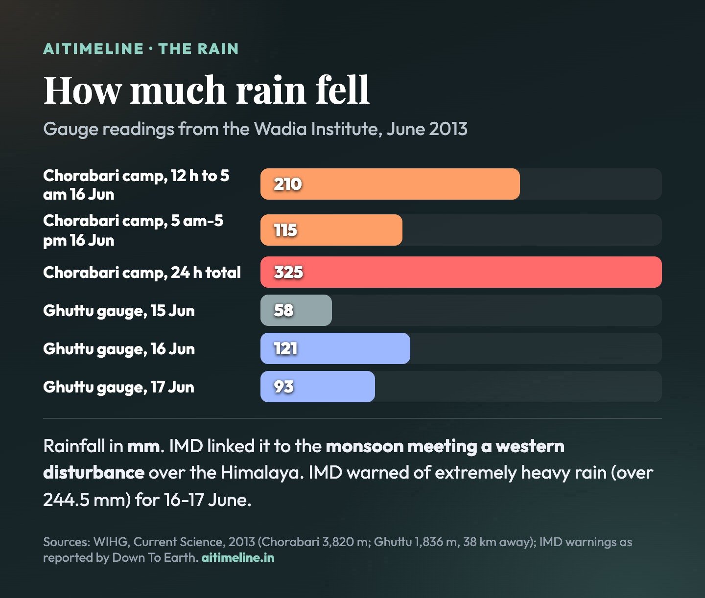
- Extreme rain: the primary trigger. The monsoon arrived early and met a western disturbance over the Himalaya, producing two days of intense, sustained rain; Chorabari station recorded 325 mm in 24 hours.
- Snowmelt and a glacial lake: rain on snow more than 7 feet thick filled Chorabari Lake, whose loose moraine dam failed on 17 June.
- Steep, glaciated terrain: a U-shaped valley with a catchment of about 67 sq km to Rambara, 23% of it glacier, funnelled water, mud and boulders onto the town.
- Where people built: the town sits on the glaciers’ outwash plain; buildings at Rambara and Gaurikund stood on loose deposits; crowding had pushed the Saraswati to flow just behind the town.
- Warnings and crowds: the IMD warned of extremely heavy rain for 16-17 June but not where; the state’s warning came at 5 pm on 16 June; peak-season pilgrims filled the valley.
A scientific distinction: the rain was the cause of both floods; the lake outburst was the mechanism of the second. Saying “the lake burst caused the disaster” is incomplete, and calling it a single cloudburst is not quite right either: scientists said the downpour resembled one but lacked the usual 100 mm-an-hour intensity.
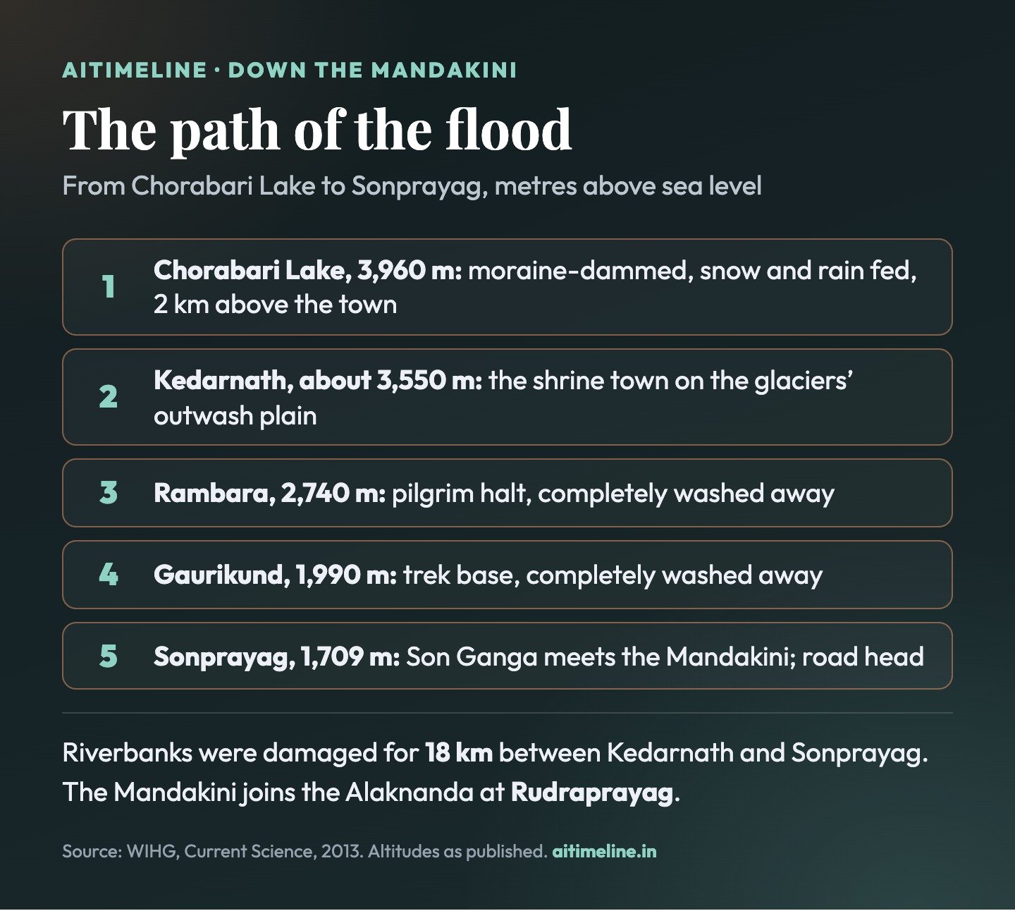
The Path of the Flood
From Chorabari Lake to Sonprayag.
The Human and Economic Cost
Every official figure is dated and provisional.

| Impact | Reported detail | Source and date |
|---|---|---|
| Deaths | 580, including 20 in the IAF crash | MHA, Rajya Sabha, 7 Aug 2013 (provisional) |
| Missing | 5,474 (Centre); 5,748 (state) | 7 Aug 2013; 15 Jul 2013 |
| Evacuated | More than 1.1 lakh people | Government figures, 2013 |
| Worst hit | Kedarnath, Rambara, Gaurikund; 18 km of Mandakini banks | WIHG, July 2013 |
| Districts | Five severely affected; works funded statewide | CAG, 2019 |
| Reconstruction package | Rs 6,259.84 crore approved (state sought Rs 9,296.21 crore) | CAG, 2019 |
| Livelihoods | Char Dham yatra halted for the 2013 season | State and temple authorities |
Timeline: The Kedarnath Floods, 2013-2026
Newest first. Colour shows the strand: before the flood, the floods, rescue and toll, rebuilding, and audit and risk.
Where things stand: a rebuilt town, a busier route Audit & risk
The 2026 season: The temple opened on 22 April 2026 and closed for winter at 8:30 am on 11 November, Bhai Dooj. PTI put the season’s Kedarnath count at more than 19.13 lakh pilgrims; the temple committee’s president was quoted by ANI at more than 19.20 lakh. The deity’s palanquin moved to the winter seat at Ukhimath.
What has changed since 2013: The town has been rebuilt behind retaining walls on the Saraswati and Mandakini, with new ghats, a rebuilt Shankaracharya samadhi, priests’ houses and pilgrim facilities. A 12.9 km ropeway from Sonprayag has been approved but is not yet built.
What has not: The valley’s exposure to extreme rain, landslides and glacial hazards is the same. The 2024 landslide on the trek route and the 2025 helicopter crash near Gaurikund both happened on the rebuilt pilgrimage corridor.
Pilgrim helicopter crashes near Gaurikund; seven killed Audit & risk
The crash: A Bell 407 helicopter operated by Aryan Aviation, carrying pilgrims back from Kedarnath, crashed in poor visibility. All seven on board, including the pilot and an infant, were killed. The Aircraft Accident Investigation Bureau took up the investigation.
Response: The government suspended Aryan Aviation’s Char Dham operations and shuttle services were briefly halted; a case was registered against two company managers. It was reported as the fifth helicopter incident on the Char Dham routes in about 40 days.
Union Cabinet approves a Sonprayag-Kedarnath ropeway Rebuilding
The project: A 12.9 km ropeway from Sonprayag to Kedarnath under the Parvatmala programme, to be built on a design, build, finance, operate and transfer basis at a capital cost of Rs 4,081.28 crore. The government said it would cut the one-way journey from 8-9 hours on foot to about 36 minutes.
Context: A Gaurikund-Kedarnath ropeway had been proposed after 2013. The CAG noted in 2019 that the state never issued sanctions for it despite central funds.
Landslide on the Gaurikund route strands thousands Audit & risk
What happened: Extremely heavy rain on the night of 31 July triggered landslides and washed out sections of the footpath above Gaurikund, stranding pilgrims along the route.
The evacuation: The NDRF reported that its teams evacuated 14,563 stranded pilgrims. The state government put the total moved by all agencies, by helicopter and on foot, at more than 15,000.
Why it matters: It was the largest emergency on the route since 2013, and a test of the evacuation planning built after it.
Prime Minister opens the rebuilt Shankaracharya samadhi Rebuilding
Inaugurated: Narendra Modi inaugurated the reconstructed samadhi of Adi Shankaracharya, destroyed in the 2013 floods, and unveiled a 12-foot statue. Completed works worth over Rs 130 crore were opened: the Saraswati retaining wall, path and ghats; the Mandakini retaining wall and path; Tirth Purohit houses; and the Garud Chatti bridge over the Mandakini.
Foundation stones: Projects worth over Rs 180 crore were begun, including Sangam Ghat redevelopment, a first-aid and tourist facilitation centre, an administrative office and hospital, two guest houses, a police station, a command and control centre, and queue management and rain shelters.
How it is reported: Some coverage gives a combined figure of about Rs 400 crore for the Kedarpuri works.
CAG audit of the reconstruction is tabled Audit & risk
The report: The Comptroller and Auditor General’s Report No. 2 of 2018, a performance audit of infrastructure reconstruction after the 2013 disaster, was tabled. It examined works and accounts up to March 2018.
Money: Of a Rs 6,259.84 crore medium- and long-term reconstruction (MLTR) package, Rs 4,617.27 crore was released and Rs 3,708.27 crore spent. Against an agreed central outlay of Rs 1,709.03 crore for centrally sponsored schemes, the state availed only Rs 215.89 crore. Rs 294.64 crore, 6.38% of releases, went to unplanned works.
Works: The audit found works sanctioned that were unrelated to the 2013 damage, Rs 5.96 crore of undue benefit to contractors, and that no implementing agency finished its works on time. Of five helidromes, 19 heliports, 34 helipads and 37 multipurpose halls targeted, only 27 helipads were built.
Audit cut-off: the Kedarnath works fall behind Rebuilding
Priests’ houses: The Nehru Institute of Mountaineering (NIM) was building only 40 of the 113 houses sanctioned for Tirth Purohits, with Rs 12.67 crore spent by September 2017; none was finished. The other 73 had not started because drawings, agreements with owners and land allotment were not finalised.
Bridges and cottages: Of three bridges sanctioned for Kedarnath town in June 2015, one had been built. Of 120 pilgrim cottages assigned to UPRNN, 92 were built but not handed over.
Sonprayag: A Rs 65 crore parking and administrative terminal at Sonprayag stalled after its foundation, awaiting a river protection wall.
Phase I of the Kedarpuri township is sanctioned Rebuilding
The plan: A district committee decided that unsafe buildings, or those in the shrine’s main path, would be demolished for a planned Kedarpuri township, sanctioned at Rs 70 crore. The state approved only phase I, for Rs 38.63 crore, covering demolition, temporary stores and 113 buildings for Tirth Purohits.
Who built it: Work went to the Nehru Institute of Mountaineering, Uttarkashi, which had been working in the town since 2014. Phase II never got funds in the audit period.
Special rules for building at 3,500 metres Rebuilding
Relaxation: In April 2015 the state allowed Kedarnath works to be given on work orders without tenders, with higher rates for labour and carriage, because of the short working season.
Sanctions: Three bridges at Kedarnath town (Rs 6 crore) were sanctioned in June 2015. In October 2015 UPRNN was assigned 120 cottages (Rs 29.72 crore) and the Sonprayag terminal (Rs 65 crore).
One year on: Home Minister reviews restoration Rescue & toll
The review: Home Minister Rajnath Singh reviewed reconstruction and the missing-person process with central and state agencies, including the issue of death certificates to families.
Forecasting: IMD officials told the meeting it would issue three-day advance weather bulletins for 14 identified locations in Uttarakhand from 20 June, updated every 12 hours, according to an IANS report.
Kedarnath reopens to pilgrims Rebuilding
Reopening: The temple’s portals reopened to devotees for the 2014 season, about ten months after the floods, with registration and other controls on the yatra.
The rebuilding begins: NIM teams had started clearing debris and making the town usable. Funding came from a central package and loans: the World Bank’s US$250 million Uttarakhand Disaster Recovery Project and the ADB’s Emergency Assistance Project, later revised to US$185 million.
Puja resumes, and the reconstruction bill is drawn up Rebuilding
Puja: On 11 September 2013, after 86 days, the chief priest performed purification rites and the first puja since the floods. It was symbolic: priests and materials were flown in, and devotees were not yet allowed.
The package: Also in September 2013, the state proposed a Rs 9,296.21 crore reconstruction package. The Centre approved a Rs 6,259.84 crore MLTR package funded by special plan assistance, centrally sponsored schemes, disaster funds, the ADB and the World Bank.
Parliament is told: 580 dead, 5,474 missing Rescue & toll
The figures: The Ministry of Home Affairs said, on provisional information from Uttarakhand, that 580 people had died, including the 20 killed in the 25 June helicopter crash, and that 5,474 were still missing.
Different counts: In mid-July the state had put the missing at 5,748. The figures were never reconciled into one final toll; most of the missing were never found and were later treated by the state as presumed dead.
IAF Mi-17 V5 crashes on a rescue sortie; 20 killed Rescue & toll
The crash: An Indian Air Force Mi-17 V5 returning from a Gauchar-Guptkashi-Kedarnath rescue sortie went down north of Gaurikund. All 20 on board died: five IAF aircrew, nine NDRF and six ITBP personnel.
Inquiry: A court of inquiry was ordered. Bad weather in the valley was reported at the time.
One of India’s largest mountain rescues Rescue & toll
Who: The Army, Indian Air Force, ITBP, NDRF, state police and civil agencies; the IAF ran its effort as Operation Rahat.
Scale: The government reported more than 1.1 lakh people evacuated across the state by the end of the operation. On 20 June, Down To Earth reported about 2,300 rescued by then and an estimated 75,000 stranded.
How: With roads and bridges gone, helicopters flew people out of Kedarnath, Gaurikund and other cut-off places, while ground teams opened foot routes.
Flood 2: Chorabari Lake breaks its moraine wall The floods
The lake: A snow- and rain-fed lake about 2 km above the town, roughly 400 m long, 200 m wide and 15-20 m deep, held back by loose glacial moraine with no surface outlet.
The breach: Days of rain and rapid melting of thick snow filled it. On the morning of 17 June the moraine dam gave way, and Wadia Institute staff at their glacier camp reported the lake drained within 5 to 10 minutes.
The damage: The surge, laden with boulders and debris, scoured both banks of the Mandakini, devastated Kedarnath town and ran on downstream. Riverbanks were damaged for 18 km to Sonprayag; Gaurikund was largely washed away.
Flood 1: the Saraswati and Dudh Ganga overflow The floods
What happened: Torrential rain flooded the Saraswati and Dudh Ganga catchments. Gullies began eroding and a sediment-laden flow struck the upper part of the town, washing away the Shankaracharya samadhi, the Jal Nigam guest house and the Bharat Seva Sangh ashram.
Downstream: Rambara, the main halt on the trek, was completely washed away the same evening.
Warnings: The state issued a disaster warning at 5 pm on 16 June, according to Down To Earth, minutes before the first flood.
Early monsoon meets a western disturbance The floods
The weather: The monsoon advanced unusually early and met a western disturbance over the Himalaya. The IMD linked the extreme rain to this convergence.
The rain: The Wadia Institute’s station at Chorabari glacier (3,820 m) recorded 210 mm in 12 hours to 5 am on 16 June and 115 mm more by 5 pm, 325 mm in 24 hours. Its gauge at Ghuttu, 38 km away, recorded 58, 121 and 93 mm on 15, 16 and 17 June.
The warnings: The IMD’s regional centre warned of heavy rain from 13 June and of extremely heavy rain (over 244.5 mm) for 16 and 17 June, but did not say which areas would be hit.
A town on a glacier’s outwash plain Before the flood
The setting: Kedarnath, one of the four Char Dham shrines, sits where the Mandakini (from Chorabari glacier) and the Saraswati (from Companion glacier) meet. The town is built on the glaciers’ outwash plain, in a U-shaped valley whose catchment to Rambara is about 67 sq km, 23% of it glacier.
The exposure: Downstream, houses at Rambara and Gaurikund stood on loose old deposits prone to landslides and river cutting. Scientists noted crowding near the temple had shifted the Saraswati’s course to flow just behind the town.
4 June 2013: Wadia Institute scientists visiting the lake twelve days before the floods found snow more than 7 feet thick around it, snow that later melted in the rain.
How Kedarnath Was Rebuilt
More than restoring a temple: a town, a trek and a road head.

Retaining walls
Walls and paths along the Saraswati and Mandakini, opened in 2021, to keep the channels off the town and the temple.
Shankaracharya samadhi
Destroyed in the 16 June flood; rebuilt and inaugurated with a statue on 5 November 2021.
Tirth Purohit houses
113 sanctioned in 2016; only 40 under way by 2018, per the CAG; houses among the works opened in 2021.
Trek, bridges and ropeway
A rebuilt trek, the Garud Chatti bridge and town bridges; a 12.9 km Sonprayag ropeway approved in 2025.
Facilities
Cottages, guest houses, a hospital, a facilitation centre, queue shelters and a command and control centre.
Forecasts and registration
Location-specific IMD bulletins from June 2014, pilgrim registration and helipads, tested again in 2024.
What the Auditors Found
CAG Report No. 2 of 2018, tabled 22 February 2019.

| Finding | Figure | What it means |
|---|---|---|
| MLTR funds released | Rs 4,617.27 cr of Rs 6,259.84 cr | 74% of the approved package reached projects |
| Spent | Rs 3,708.27 cr | 59% of the approved outlay by March 2018 |
| Central scheme funds availed | Rs 215.89 cr of Rs 1,709.03 cr | The state drew a small share of central scheme money |
| Diverted to unplanned works | Rs 294.64 cr (6.38%) | Money went to works outside the plan |
| Undue benefit to contractors | Rs 5.96 cr | Paid by project implementing units |
| Disaster shelters | 27 helipads; 0 of 37 halls | Against 5 helidromes, 19 heliports, 34 helipads targeted |
| Kedarnath route works | 40 of 56 complete | After four yatra seasons |
Key People and Institutions
| Name | Role |
|---|---|
| Wadia Institute of Himalayan Geology | Ran the Chorabari glacier camp; its scientists documented the two floods |
| India Meteorological Department | Issued heavy-rain warnings in June 2013; location bulletins from 2014 |
| Indian Army, IAF, ITBP, NDRF | Led the 2013 rescue; the NDRF again in 2024 |
| Ministry of Home Affairs | Gave Parliament the provisional toll in August 2013 |
| Vijay Bahuguna | Uttarakhand Chief Minister during the floods |
| Harish Rawat | Chief Minister from February 2014, as rebuilding began |
| Nehru Institute of Mountaineering | Main builder in Kedarnath town, including priests’ houses |
| Comptroller and Auditor General | Audited reconstruction up to March 2018 |
| Narendra Modi | Inaugurated the rebuilt samadhi and works on 5 November 2021 |
Lessons From Kedarnath
- Build away from the water: outwash plains and old river deposits are where floods go; the 2013 losses tracked them closely.
- Warnings need a place and a person: a statewide forecast of extreme rain did not tell anyone in Kedarnath to leave.
- Pilgrim numbers are a hazard factor: registration, crowd limits and evacuation plans are disaster management.
- Watch the glacial lakes: Chorabari was small and still drained catastrophically in minutes.
- Audit the rebuilding: the CAG showed how slow sanctions, diverted funds and weak monitoring stall recovery.
- Preparedness does not end: the 2024 landslide hit a rebuilt route; new buildings do not change the valley.
Explore More Timelines
People Also Ask
Frequently Asked Questions
Based on the Wadia Institute’s study, parliamentary replies, the CAG audit and reporting to 16 November 2026.
⚠️ Editorial Note: What We Corrected and What We Could Not Confirm
This page draws on the Wadia Institute of Himalayan Geology’s July 2013 study in Current Science, the Home Ministry’s reply to the Rajya Sabha of 7 August 2013, the CAG’s Report No. 2 of 2018, and agency and news reports. The brief we started from gave a statewide rainfall figure of 385.1 mm against a normal of 71.3 mm (440% excess) for 15-18 June; we could not match those numbers to an IMD source and used the institute’s gauge readings instead. The brief said all 13 districts were affected; the CAG describes five severely affected districts, with some funds statewide. The brief tied Rs 38.63 crore to 113 houses; the CAG shows that was the whole of phase I, including demolition and temporary stores, sanctioned in September 2016, and that NIM was building 40 houses as of September 2017. We could not confirm a May 2014 reconstruction announcement by Harish Rawat, or the brief’s two bodies recovered in the 2024 landslide, and did not use them. The 580 deaths and 5,474 missing are provisional; the state’s July 2013 figure was 5,748 missing. We added the timing of the first flood, the June 2025 helicopter crash, the 2025 ropeway approval and the 2026 season. The temple’s surviving boulder is widely reported but not described in the scientific study we used. The CAG’s findings relate to its audit period and are not an assessment of later construction.
Related Reading on AiTimeline
Sources & further reading
Every dated entry above was checked against these references. Last reviewed 16 November 2026.
- Dobhal et al., Kedarnath disaster: facts and plausible causes, Current Science 105(2), 25 July 2013 (Wadia Institute of Himalayan Geology)
- CAG: Report No. 2 of 2018, Performance audit on reconstruction of infrastructure post 2013 disaster in Uttarakhand (tabled 22 February 2019)
- CAG Report No. 2 of 2018, Chapter 3: Planning and reconstruction of damaged infrastructure (Kedarnath works)
- Business Standard / PTI: 580 dead in unprecedented Uttarakhand calamity, says government (August 2013)
- Down To Earth: Uttarakhand government ignored Met warning (20 June 2013)
- MAUSAM (IMD): Exceptionally heavy rainfall over Uttarakhand during 15-18 June 2013, a case study
- Business Standard / IANS: Kedarnath temple opens after 86 days (11 September 2013)
- Business Standard / IANS: 2013 Uttarakhand disaster, Rajnath reviews restoration (17 June 2014)
- Swarajya: PM Modi inaugurates, lays foundation stone of development projects in Kedarnath (5 November 2021)
- The Tribune: Cabinet clears Kedarnath ropeway to cut travel time from 8-9 hours to 36 minutes (5 March 2025)
- The Tribune: Helicopter crash, operations of Aryan Aviation for Char Dham yatra suspended (15 June 2025)
- Telangana Today / PTI: Kedarnath, Yamunotri temples close for winter after over 28 lakh pilgrim visits (11 November 2026)