← AiTimeline Home

India’s Eyes in Space

India’s Earth Observation Satellite Timeline 1988–2026: From IRS-1A to EOS-05

📅 Updated 4 September 2026Science · ISRO18 min read
Advertisement

View as Web Story

In short

From IRS-1A to EOS-05, explore how India's Earth-observation satellites map crops, oceans, floods, cities and changing landscapes.

On 4 September 2026, ISRO’s GSLV-F17 rocket lifted off from Sriharikota carrying EOS-05, a satellite ISRO describes as India’s first-ever imaging spacecraft placed into geosynchronous orbit. It is the newest entry in a programme that began 38 years earlier with a much simpler satellite, IRS-1A. This India Earth observation satellite timeline traces that full arc — from IRS-1A in 1988 through Cartosat, Resourcesat, Oceansat and RISAT, to the EOS series and EOS-05 in 2026 — and explains a fact that gets lost in “spy satellite” headlines: an eye in space is not one camera. Different ISRO satellites carry different instruments, fly in different orbits, and answer different questions.

🧠 AI Overview Summary

EOS-05, launched by GSLV-F17 on 4 September 2026, is ISRO’s first imaging satellite placed into geosynchronous orbit — a much higher, farther orbit than the low-Earth-orbit satellites (Cartosat, Resourcesat, RISAT) that make up most of India’s Earth-observation fleet. A geosynchronous platform can repeatedly view the same broad region of Earth from far above, unlike low-orbit satellites that pass over a location only at set intervals. EOS-05’s exact operational imaging performance depends on completed orbit-raising and commissioning, which ISRO has not yet detailed publicly.

Satellite typeMain strengthKey limitation
Optical imagingDetailed land and city imageryClouds and darkness block the view
Multispectral imagingCrops, vegetation and land useNeeds multiple bands plus ground data to interpret
SAR / radarWorks through clouds and at nightImage interpretation is more complex than a photo
Ocean sensorsSea colour, winds and fisheries inputsBuilt for ocean applications, not street-level maps
Geosynchronous imagingFrequent view of the same broad areaFar greater distance creates resolution trade-offs

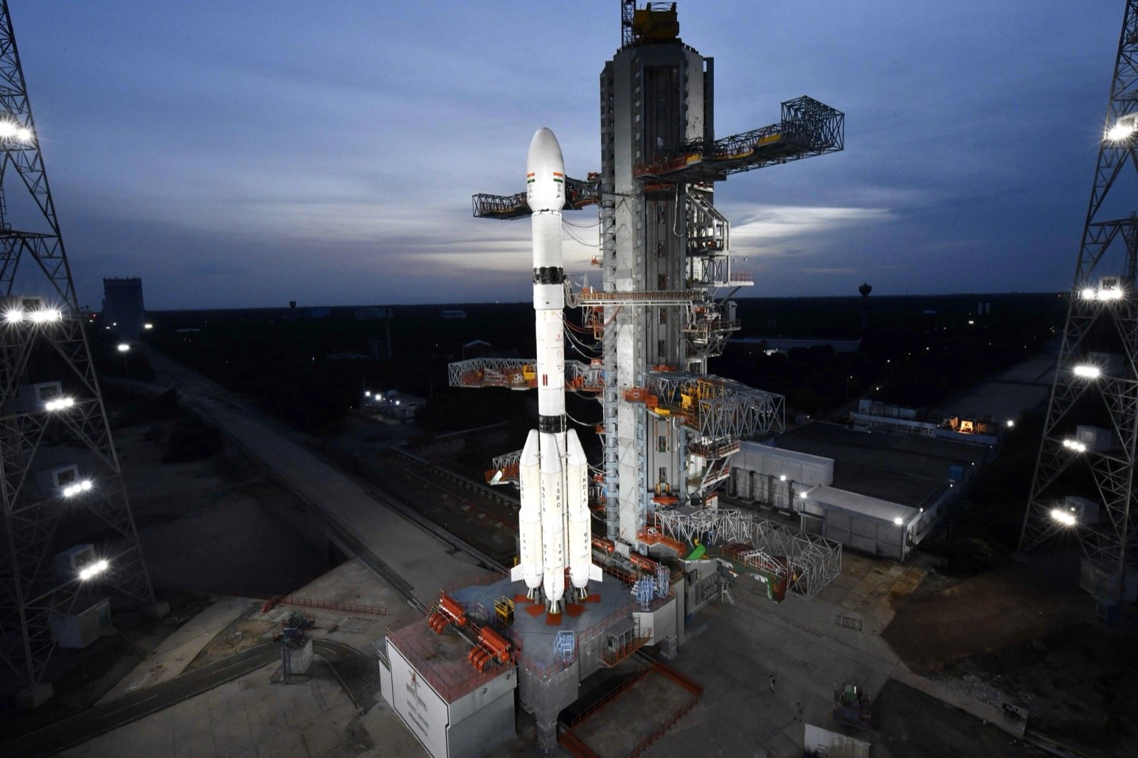
GSLV-F17 rocket carrying EOS-05 on the launch pad at Satish Dhawan Space Centre, Sriharikota

GSLV-F17 on the second launch pad at Sriharikota ahead of the EOS-05 launch. Credit: ISRO (GODL-India)

⚡ Quick Facts
Programme startIRS-1A, 17 March 1988
Latest launchEOS-05, 4 September 2026
Launch vehicles usedPSLV, GSLV, GSLV Mk III, SSLV
Radar (SAR) familyRISAT-1/2, EOS-04, EOS-09
Ocean familyOceansat-1/2/3 (EOS-06)
Free public dataBhuvan & MOSDAC (NRSC/ISRO)
⚡ Quick Answers — AI Overview Ready

India’s Earth Observation: Key Questions

Is EOS-05 India’s first satellite aimed at geosynchronous orbit?
Not the first attempt — EOS-03 tried this in 2021 and failed to reach orbit after a cryogenic-stage anomaly. EOS-05 is ISRO’s first satellite to successfully reach a geosynchronous transfer path for imaging, per ISRO’s own mission description.
Do Indian satellites see through clouds?
Only the radar (SAR) satellites — RISAT and EOS-04 — can. They send their own microwave signal and read the reflection, so cloud cover and darkness do not block them. Optical satellites like Cartosat cannot.
Can ISRO satellites see individual people or inside buildings?
No. Public ISRO Earth-observation satellites are not built or disclosed to identify individuals or see indoors. Resolution, orbit, weather and data-access rules all limit what any of them can show.
What was India’s very first Earth-observation satellite?
IRS-1A, launched on 17 March 1988. It marked the start of India’s operational remote-sensing programme and carried basic optical sensors for land-resource mapping.
📚 Key Takeaways

What to Know Before You Read Further

  • One programme, many instruments: optical (Cartosat), multispectral (Resourcesat), ocean-colour (Oceansat), radar (RISAT/EOS-04) and now geosynchronous imaging (EOS-05) are different tools, not one all-seeing camera.
  • 1988 start: IRS-1A began India’s operational remote-sensing era; nearly four decades and 25-plus missions later, EOS-05 is the newest.
  • EOS-05 is a first, but not the first attempt: EOS-03 tried for geosynchronous imaging in 2021 and was lost to a launch anomaly.
  • Radar ≠ photograph: Synthetic Aperture Radar (SAR) satellites like RISAT work at night and through clouds, but their images need specialist interpretation, not a glance.
  • Optical satellites are grounded by weather: Cartosat and Resourcesat need daylight and clear skies to capture usable imagery.
  • Not every mission succeeded: EOS-03 (2021) and EOS-09 (2025) both suffered launch failures — this timeline includes them, not just the wins.
  • Orbit changes capability: low-Earth-orbit satellites pass over a spot at set intervals; a geosynchronous satellite can view the same broad region repeatedly, at the cost of resolution.
  • Satellites inform, they don’t decide: flood maps, crop assessments and disaster response all pair satellite data with ground teams and other data sources.
  • Data is public: Bhuvan and MOSDAC give citizens, researchers and planners free access to much of this imagery.
  • EOS-05’s full capability is still unfolding: orbit-raising, commissioning and payload performance details had not been separately confirmed by ISRO as of this update.

India’s Earth-Observation Timeline: 1988–2026

Chronological, oldest to newest — the milestones that built up India’s Earth-observation capability, including the missions that did not succeed.

IRS-1A — India’s remote-sensing programme begins Mission completed

17 March 1988Vostok launch vehicleSun-synchronous polar orbit

Instrument: Optical/multispectral imaging (LISS-I and LISS-II cameras).

Why it mattered: IRS-1A was India’s first operational remote-sensing satellite, built for land-resource mapping — agriculture, forestry, water bodies. It marked the point where ISRO moved from experimental payloads to a working civilian Earth-observation service.

Interesting fact: IRS-1A launched on a Soviet Vostok rocket — India’s own launch vehicles were not yet capable of putting it in orbit.
1990s

IRS-1B, IRS-P2, IRS-1C, IRS-P3, IRS-1D — the IRS constellation expands Mission completed

1991–1997PSLV, Vostok, Molniya launchesSun-synchronous polar orbit

Instruments: Improved optical and panchromatic cameras (PAN, LISS-III, WiFS) across the series.

Why it mattered: Through the 1990s ISRO launched IRS-1B (1991), IRS-P2 (1994, ISRO’s own PSLV-D2), IRS-1C (1995), IRS-P3 (1996) and IRS-1D (1997), each adding resolution or coverage. This decade also proved out India’s own PSLV as a reliable launch vehicle for these missions.

Interesting fact: IRS-1C and IRS-1D’s panchromatic imagery was considered high-resolution enough in the late 1990s that India briefly became a commercial data supplier to foreign users.

Oceansat-1 (IRS-P4) — India looks at the ocean Mission completed

26 May 1999PSLV-C2Sun-synchronous polar orbit

Instruments: Ocean Colour Monitor (OCM) and a scatterometer for sea-surface winds.

Why it mattered: India’s first dedicated ocean-observation satellite. It supported fisheries advisories, ocean-productivity mapping and marine-weather inputs — a different job entirely from the land-mapping IRS series.

Interesting fact: Oceansat-1’s scatterometer data fed into early cyclone-track forecasting for the Indian Ocean region.

Resourcesat-1 — farms, water and forests get a dedicated satellite Mission completed

17 October 2003PSLV-C5Sun-synchronous polar orbit

Instrument: Multispectral sensors — LISS-III, LISS-IV and AWiFS — at varying resolutions and swath widths.

Why it mattered: Resourcesat-1 built a dedicated capability for agriculture, land-use and water-resource monitoring, distinct from Cartosat’s cartographic focus. Its multi-resolution design let one satellite serve both district-level and field-level analysis.

Interesting fact: Resourcesat-1 data became a standard input for India’s crop-acreage and drought-assessment programmes.

Cartosat-1 — India starts mapping in 3D Mission completed

5 May 2005PSLV-C6Sun-synchronous polar orbit

Instrument: Twin panchromatic cameras, one pointed fore and one aft, for stereo imaging.

Why it mattered: Cartosat-1 was built specifically for cartography and terrain mapping — its stereo pair let ISRO generate elevation models, not just flat images. This began a Cartosat line focused on precision mapping and infrastructure monitoring, separate from Resourcesat’s land-resource focus.

Interesting fact: Cartosat-1’s stereo imagery was used to update India’s topographic map series, some of which predated satellite mapping entirely.
2009+

RISAT radar missions begin — seeing through clouds and at night Operational

RISAT-2: 20 Apr 2009RISAT-1: 26 Apr 2012RISAT-2B/2BR1: 2019

Instrument: Synthetic Aperture Radar (SAR), C-band on RISAT-1, X-band on the RISAT-2 series.

Why it mattered: India’s monsoon means weeks of cloud cover every year — exactly when flood monitoring matters most, and exactly when optical satellites are blind. RISAT-2 (2009) arrived first as a fast-tracked mission; RISAT-1 (2012), India’s own indigenous SAR satellite, followed. RISAT-2B and RISAT-2BR1 (both 2019) extended the radar fleet.

Interesting fact: RISAT-2 launched three years before RISAT-1 despite the numbering — it was fast-tracked as a stopgap while India’s own indigenous SAR satellite was still in development, according to independent reporting; ISRO’s own mission pages do not detail the reason.
2010s

The 2010s — Cartosat, Resourcesat, Oceansat and RISAT all expand Operational

2009–2019Mostly PSLV launchesSun-synchronous polar orbit

Missions: Oceansat-2 (2009), Cartosat-2B (2010), Resourcesat-2 (2011), Scatsat-1 (2016, Ku-band scatterometer for wind and cyclone monitoring), Resourcesat-2A (2016), a run of Cartosat-2 series satellites (2016–2018) providing high-resolution panchromatic imagery, and Cartosat-3 (2019) — ISRO’s most capable civilian mapping satellite at the time, with very-high-resolution panchromatic and multispectral imaging.

Why it mattered: By the end of this decade, India had continuous, overlapping coverage across every observation type — optical, multispectral, ocean and radar — rather than relying on any single satellite.

Interesting fact: This decade is when Indian Earth-observation data moved from occasional government use to routine input for agriculture insurance, urban planning and disaster response.

EOS-01 — a new naming era begins Operational

7 November 2020PSLV-C49Sun-synchronous polar orbit

Instrument: Synthetic Aperture Radar, in the RISAT capability class.

Why it mattered: EOS-01 opened ISRO’s new “Earth Observation Satellite” naming convention, which now covers a range of different payload types under one numbering scheme rather than separate IRS/Cartosat/RISAT family names. Applications include agriculture, forestry and disaster-management support.

Interesting fact: The EOS naming scheme does not mean every EOS satellite shares one design — EOS-01 is radar, while later EOS satellites carry optical, ocean and geosynchronous-imaging payloads.

EOS-03 — launch unsuccessful Launch unsuccessful

12 August 2021GSLV-F10Intended: geosynchronous transfer orbit

What was planned: EOS-03 was designed as an agile Earth-observation satellite meant to reach a geosynchronous transfer orbit via GSLV-F10, then use its own propulsion to reach final geostationary orbit — enabling near-real-time imaging of India for tracking cyclones, cloudbursts and other fast-moving disasters.

What happened: The mission failed. ISRO’s own account: a technical anomaly in the cryogenic upper stage meant the stage did not ignite as planned roughly 4.5 minutes after liftoff, and the mission could not be accomplished. Both the satellite and the rocket’s cryogenic stage were lost.

Interesting fact: EOS-03 was India’s first attempt at a geosynchronous-orbit imaging satellite. It never reached orbit — which is why EOS-05, five years later, is described by ISRO as the first satellite to actually achieve that goal.

EOS-04 and EOS-06 — radar and ocean-watching return Operational

EOS-04: 14 Feb 2022EOS-06: 26 Nov 2022PSLV launches

EOS-04 (also called RISAT-1A): C-band Synthetic Aperture Radar, sun-synchronous polar orbit, launched via PSLV-C52. Supports all-weather agriculture, soil-moisture and flood monitoring — a direct successor to RISAT-1’s capability.

EOS-06 (Oceansat-3): Ocean-colour and related sensors, launched via PSLV-C54. Continues India’s ocean-observation line for fisheries, sea-surface conditions and coastal applications.

Interesting fact: EOS-04 and EOS-06 show how differently the EOS name is used — one is a radar satellite, the other an ocean-colour satellite, launched nine months apart.
2023–25

EOS-07, EOS-08, EOS-09 and NISAR — setbacks and an international first Mixed outcomes

Feb 2023 – Jul 2025SSLV, PSLV, GSLV launches

EOS-07 (10 Feb 2023, SSLV-D2): a small-satellite technology-demonstration mission — Capability under evaluation at launch.

EOS-08 (16 Jan 2024, SSLV-D3): a compact ~175 kg satellite carrying an Electro-Optical Infrared payload (day/night imaging), a GNSS-Reflectometry sensor for soil moisture, ocean winds and flood detection, and a radiation dosimeter supporting the Gaganyaan human-spaceflight programme. Designed for roughly a one-year mission life — Mission completed by its nominal design life.

EOS-09 (18 May 2025, PSLV-C61): a Synthetic Aperture Radar satellite intended for sun-synchronous orbit. ISRO’s own account: performance was normal through the second stage, but an observation in the third stage meant the mission could not be accomplished — Launch unsuccessful.

NISAR (30 July 2025, GSLV-F16): a joint NASA–ISRO dual-frequency (L-band and S-band) Synthetic Aperture Radar satellite — the first Earth-observation mission jointly built by the two space agencies. Operational.

Interesting fact: In under three years India both lost a Synthetic Aperture Radar satellite to a launch failure (EOS-09) and successfully flew its first satellite jointly engineered with NASA (NISAR).

EOS-05 launches — India’s first successful geosynchronous imaging satellite In orbit-raising / commissioning

4 September 2026, 02:55 AM ISTGSLV-F17Sub-Geosynchronous Transfer Orbit

What happened: GSLV-F17 lifted off from the Second Launch Pad at Satish Dhawan Space Centre, Sriharikota, and placed EOS-05 into a Sub-Geosynchronous Transfer Orbit (Sub-GTO) roughly 19 minutes after launch. ISRO’s own statement: “GSLV-F17 has successfully accomplished its mission, placing EOS-05 into the intended orbit,” describing EOS-05 as “India’s first ever imaging satellite from Geosynchronous orbit.”

What comes next: Reaching Sub-GTO is a staging step, not the satellite’s final position — EOS-05 still needs further orbit-raising to reach its operating geosynchronous slot, and ISRO had not published a commissioning-complete statement, detailed payload specifications, or operational imaging performance figures as of this update. See the EOS-05 status box below for what is confirmed and what is still awaited.

Interesting fact: EOS-05 was known by the pre-launch designation GISAT-1A — a name that referenced the earlier, unsuccessful GISAT/EOS-03 attempt at the same geosynchronous-imaging goal.

From IRS to EOS: How India’s Satellites Became Specialised

Each satellite family answers a different observation question. None of them replaces the others.

Satellite familyMain observation typeTypical usesImportant limitation
IRSOptical and remote sensingLand, agriculture and resourcesDepends on the specific sensor and orbit flown
CartosatHigh-resolution mappingTerrain, infrastructure and urban mappingOptical imagery affected by clouds and darkness
ResourcesatMultispectral land observationCrops, water and land-use analysisData interpretation needs context and ground truth
OceansatOcean observationOcean colour, winds and fisheries supportNot designed for detailed city-level mapping
RISATSynthetic Aperture RadarFloods, all-weather observation and terrainRadar images need specialist interpretation
EOS seriesDifferent payloads and mission typesEarth-observation applications generallyEOS does not describe one single sensor type
EOS-05Geosynchronous imaging missionRepeated broad-area observationFull post-commissioning capability still to be confirmed

What Can India’s Satellites Actually See?

Satellites collect data. Scientists and agencies interpret it, using models, field data and local information.

ApplicationWhat satellite data can help showWhat it cannot prove alone
AgricultureCrop area, vegetation condition, drought patternsExact yield or farmer-level conditions without ground data
FloodsWater spread, inundation patterns, damaged access routesFull on-ground impact without field reporting
CyclonesCloud systems, winds, ocean conditions and land impactExact local damage before ground verification
ForestsLand-cover change and vegetation stressEvery cause of forest loss without further analysis
OceansSea-surface conditions, chlorophyll patterns and windsExact fish catch or local water quality without supporting data
CitiesUrban growth, roads, land use and infrastructure changePrivate indoor activity or individual identity
Disaster responseAreas that need field assessmentA replacement for emergency teams on the ground

Optical, Radar and Ocean Sensors: Why One Satellite Cannot Do Everything

Optical & Multispectral

Cartosat, Resourcesat

Captures visible and infrared light — best for detailed land, vegetation, water and infrastructure imagery. Limited by cloud cover and darkness; needs daylight and clear skies.

Synthetic Aperture Radar

RISAT, EOS-04

Sends its own radar signal and measures the return. Works at night and through clouds. Not an ordinary photograph — SAR images need trained interpretation to read.

Ocean Sensors

Oceansat, EOS-06

Measures ocean colour, sea-surface winds and related marine conditions. Useful for fisheries advisories, weather inputs and coastal studies — not general-purpose imagery.

Geosynchronous Imaging

EOS-05

Positioned much farther from Earth than the other three, to repeatedly view the same broad region. Full imaging performance depends on completed commissioning, still to be confirmed.

Sunlight (optical) or radar pulse (SAR) reflects off or returns from the Earth’s surface
Satellite sensor records the reflected light or radar return
Ground station receives the downlinked raw data
Processed map or data product is generated from the raw signal
Decision support for agencies, planners and researchers

Why Orbit Changes What a Satellite Can Do

Orbit typeTypical altitudeStrengthTrade-off
Low Earth OrbitHundreds of kilometresHigher-detail observation, specialised instrumentsSatellite passes over a place only at intervals
Sun-synchronous orbitLow Earth orbit, fixed local solar timeComparable images across repeat passesNot continuous viewing of any one location
Geosynchronous orbitAround 36,000 kmRepeated view of the same broad regionMuch farther from Earth, with resolution trade-offs

EOS-05’s exact altitude and final orbit configuration are ISRO’s to confirm once orbit-raising and commissioning are complete — this article does not state figures beyond what ISRO has published.

How Satellite Data Becomes Useful on the Ground

Satellite observation — raw imagery or radar returns captured in orbit
Ground receiving station — NRSC and partner stations download the data
Calibration and processing — correcting for atmosphere, geometry and sensor noise
Map or data product — published via Bhuvan, MOSDAC or agency-specific tools
State agency, farmer, planner or disaster-response team — combines it with local knowledge to act
  • Crop and drought assessment — comparing vegetation health across a growing season
  • Flood mapping — tracking inundation extent as water recedes
  • Coastal planning — monitoring shoreline change and erosion
  • Fishery advisories — pointing vessels toward likely fishing zones from ocean-colour data
  • Urban planning — tracking built-up area growth against city master plans
  • Watershed and land-use monitoring — following change across river basins
  • Post-disaster assessment — a first look at damage extent before field teams arrive

Satellite data does not make decisions on its own. It supports the experts and local officials who do — a flood map tells you where water is, not what a district administration should do about it.

EOS-05: What Is Confirmed and What Comes Next

Status Box — updated 4 September 2026
Was EOS-05 launched?Yes — 4 September 2026, ISRO’s GSLV-F17 mission page
What vehicle launched it?GSLV-F17
Orbit achieved after launchSub-Geosynchronous Transfer Orbit (Sub-GTO), per ISRO
Intended for geosynchronous imaging?Yes — ISRO calls it India’s first imaging satellite from geosynchronous orbit
Is final orbit-raising complete?Not yet confirmed by ISRO — verify before treating as final
Are full payload specs public?Not yet published in detail — link official ISRO pages only
Is the satellite fully commissioned?Not yet confirmed by ISRO
This section will be updated as ISRO publishes orbit-raising, commissioning and payload information. Do not treat EOS-05 as fully operational in its final geosynchronous slot until ISRO confirms it.

India’s Earth-Observation Future

Several directions are visible from where the programme stands today, though timelines for all of them depend on future ISRO confirmation rather than announced schedules:

  • More frequent Earth observation as radar and optical constellations grow — subject to future launches
  • Radar and optical data increasingly used together for a fuller picture of the same event
  • Better geospatial-data platforms building on Bhuvan and MOSDAC
  • AI-assisted analysis of satellite imagery for faster flood, crop and disaster mapping — an emerging capability, not yet a settled standard
  • Growing private-sector participation in Indian Earth-observation smallsats, alongside ISRO’s own missions
  • International collaboration, building on the NASA-ISRO NISAR mission, where specific future missions are officially confirmed

⚠️ Editorial Note

This article separates what ISRO has officially stated from what is inferred or drawn from independent reporting — each is labelled as such in the text above. Mission dates, statuses and technical details are sourced from ISRO’s own mission pages wherever possible; figures ISRO has not yet published (such as EOS-05’s final orbit, resolution or commissioning date) are marked “not yet confirmed” rather than estimated.

People Also Ask

Is EOS-05 a spy satellite?
ISRO describes EOS-05 as an Earth-observation satellite for geosynchronous imaging; it has not officially disclosed any military or intelligence application. Any security use is not publicly confirmed, so calling it a “spy satellite” goes beyond what ISRO has stated.
How is EOS-05 different from Chandrayaan or Gaganyaan?
Chandrayaan is a lunar exploration programme and Gaganyaan is India’s human-spaceflight programme — both aimed beyond or into orbit for exploration and crewed missions. EOS-05 and the wider EOS series instead orbit Earth to observe it, for applications like agriculture, disaster management and mapping.
Does India have real-time satellite surveillance of the whole country?
No continuous, whole-country real-time surveillance capability has been officially confirmed by ISRO. A geosynchronous satellite like EOS-05 can potentially observe the same broad region repeatedly, but actual revisit frequency, tasking priorities and coverage depend on confirmed operational details ISRO has not yet released.
Why did India build so many different Earth-observation satellites instead of one advanced one?
Because no single sensor or orbit can do every job well. Optical cameras need daylight and clear skies; radar works through clouds but needs specialist reading; ocean sensors are tuned for sea conditions, not land. Running separate specialised satellites covers more ground than one generalist satellite could.

Frequently Asked Questions

What was India’s first remote-sensing satellite?
IRS-1A, launched on 17 March 1988 aboard a Soviet Vostok rocket. It carried basic optical sensors for land-resource mapping and marked the start of India’s operational, continuous remote-sensing programme — the foundation everything from Cartosat to EOS-05 built on.
What is EOS-05?
EOS-05 is an ISRO Earth-observation satellite launched on 4 September 2026 by GSLV-F17. ISRO describes it as India’s first imaging satellite placed into geosynchronous orbit, initially reaching a Sub-Geosynchronous Transfer Orbit. Its detailed payload specifications and final operational status had not been separately published as of this update.
Why is EOS-05 different from low-Earth-orbit imaging satellites?
Low-Earth-orbit satellites like Cartosat pass over any given location only at set intervals, days apart. A geosynchronous platform sits much farther from Earth — around 36,000 km at that orbit class — which can let it observe the same broad region repeatedly, at the cost of the fine resolution low orbit allows.
What can Cartosat satellites be used for?
Cartosat satellites carry high-resolution panchromatic cameras built for cartography, terrain mapping and infrastructure monitoring. Cartosat-1 pioneered stereo imaging for elevation models; later Cartosat-2 and Cartosat-3 satellites pushed resolution higher for urban and infrastructure mapping. All are optical, so they need daylight and clear skies.
What is Resourcesat used for?
Resourcesat satellites carry multispectral sensors (LISS-III, LISS-IV, AWiFS) tuned for agriculture, land-use and water-resource monitoring. They’re a standard input for India’s crop-acreage estimates and drought assessments, working at multiple resolutions to cover both broad regional trends and finer field-level detail.
What does Oceansat observe?
Oceansat satellites carry an Ocean Colour Monitor and, on most missions, a scatterometer for sea-surface winds. They support fisheries advisories, ocean-productivity mapping and inputs to cyclone-track forecasting — a different observation job from the land-focused IRS, Cartosat and Resourcesat families.
What is RISAT and how does radar imaging work?
RISAT satellites carry Synthetic Aperture Radar (SAR), which sends its own microwave signal toward the ground and measures the reflection, rather than relying on sunlight. This lets RISAT image through cloud cover and in darkness — valuable during India’s monsoon floods — though SAR images need specialist interpretation, unlike an ordinary photograph.
Can Indian satellites see through clouds?
Only the radar-carrying satellites can — RISAT-1, RISAT-2, EOS-01 and EOS-04 all use Synthetic Aperture Radar, which is not blocked by clouds or darkness. Optical satellites such as Cartosat and Resourcesat cannot see through cloud cover; they need clear daylight conditions to capture usable imagery.
Can satellites identify people or see inside houses?
No. India’s public Earth-observation satellites are not built, nor officially disclosed, to identify individuals or see inside buildings. Resolution limits, orbital altitude, weather conditions, revisit frequency and data-access rules all constrain what any of these satellites can actually show — well short of that level of detail.
What is the difference between optical and radar satellite imagery?
Optical imagery works like a camera, capturing reflected sunlight — it needs daylight and clear skies, but produces intuitive, photo-like images. Radar (SAR) imagery works by measuring a satellite’s own reflected microwave signal, which works day or night and through cloud cover, but produces a different kind of image that needs specialist training to read correctly.
How are Indian satellite images used in disaster management?
Satellite data helps map flood extent, track cyclone systems, spot landslide-prone terrain and give a first look at damage after an event. RISAT and EOS-04’s radar imaging is especially useful here because disasters like floods often coincide with heavy cloud cover that blocks optical satellites. Field teams still verify and act on the ground.
Where can the public access Indian geospatial data?
ISRO’s National Remote Sensing Centre (NRSC) runs Bhuvan, a public geoportal for browsing and downloading Indian satellite imagery and derived products, and MOSDAC, which focuses on meteorological and oceanographic satellite data. Both offer free access to much of India’s Earth-observation output for research, education and planning use.
What does ISRO mean by “Earth Observation Satellite” or EOS?
EOS is ISRO’s current naming convention for Earth-observation missions, replacing the separate IRS, Cartosat, Resourcesat and RISAT family names with one numbered series. Despite the shared name, EOS satellites carry very different payloads — EOS-01 is radar, EOS-06 is an ocean-colour satellite, and EOS-05 is a geosynchronous imaging mission.
What happened to EOS-03?
EOS-03 launched on 12 August 2021 aboard GSLV-F10, intended to become India’s first geosynchronous-orbit imaging satellite. The mission failed: ISRO reported a technical anomaly in the cryogenic upper stage meant it did not ignite as planned, and the satellite did not reach orbit. It is the direct predecessor to EOS-05’s successful 2026 attempt.
What is a sun-synchronous orbit and why do most Indian Earth-observation satellites use it?
A sun-synchronous orbit is a low-Earth polar orbit timed so a satellite passes over any given location at roughly the same local solar time on every orbit. This keeps lighting conditions consistent across repeat images, which is valuable for comparing land, crop or water changes over time — most of India’s Cartosat, Resourcesat and RISAT satellites fly in this orbit type.
What is a geosynchronous orbit, in simple terms?
A geosynchronous orbit sits much farther from Earth — around 36,000 km — where a satellite’s orbital period matches Earth’s rotation, letting it stay over roughly the same region of the planet. This can enable more frequent viewing of that region, though a geosynchronous satellite’s much greater distance means lower ground resolution than a low-Earth-orbit satellite achieves.
Does a geosynchronous satellite provide continuous, real-time imaging?
Not automatically. A geosynchronous orbit can enable more frequent observation of the same broad region, but actual imaging frequency depends on the specific instrument’s capability, tasking decisions and operational status — none of which ISRO has detailed publicly for EOS-05 as of this update. Continuous real-time imaging should not be assumed without official confirmation.
What launch vehicles has India used for its Earth-observation satellites?
Early missions like IRS-1A and IRS-1C launched on Soviet Vostok and Molniya rockets before India’s own PSLV became reliable. Since the mid-1990s, most Earth-observation satellites have flown on PSLV; heavier or geosynchronous-bound missions like EOS-03 and EOS-05 use the more powerful GSLV; smaller technology-demonstration satellites like EOS-07 have flown on the newer SSLV.
What is NISAR and how does it relate to India’s Earth-observation programme?
NISAR (NASA-ISRO Synthetic Aperture Radar) is a joint satellite built by NASA and ISRO, launched on 30 July 2025 aboard GSLV-F16. It carries dual-frequency L-band and S-band radar, making it India’s first Earth-observation mission co-engineered with another space agency, and a significant step up in radar capability from earlier RISAT and EOS-04 missions.
Have any Indian Earth-observation satellite launches failed?
Yes. EOS-03 (August 2021) was lost after a cryogenic-stage anomaly on GSLV-F10, and EOS-09 (May 2025) failed after an issue in the third stage of PSLV-C61. Both are included in this timeline for accuracy — ISRO’s Earth-observation record includes real setbacks alongside its successes.
What is the difference between Cartosat and Resourcesat?
Cartosat is built for high-resolution mapping and cartography — terrain models, infrastructure and urban detail. Resourcesat is built for multispectral land-resource monitoring — crops, water bodies and vegetation health. Both are optical satellite families, but they carry different instruments tuned for different questions.
What resolution do India’s Earth-observation satellites offer?
Resolution varies widely by mission and instrument — Cartosat-3 offers ISRO’s highest publicly stated civilian resolution to date, while Resourcesat and Oceansat instruments are tuned for broader regional coverage rather than fine detail. This article does not state a specific resolution figure for EOS-05, since ISRO has not yet published one.
Is India’s satellite imagery used for agriculture insurance?
Resourcesat and related multispectral data are commonly used as an input for crop-area and drought assessments that inform agricultural planning and insurance schemes in India, alongside ground survey data — satellite imagery supports these assessments rather than fully replacing field verification.
How often do India’s satellites revisit the same location?
Revisit frequency depends on the specific satellite’s orbit and swath width — it typically ranges from a few days to a couple of weeks for most sun-synchronous Earth-observation satellites. A geosynchronous satellite like EOS-05 could potentially offer more frequent views of the same broad region, though exact revisit figures for it have not yet been officially published.
What is a scatterometer and which Indian satellites carry one?
A scatterometer measures how radar signals bounce off the ocean surface to estimate wind speed and direction. Oceansat-1, Oceansat-2 and the dedicated Scatsat-1 mission all carried scatterometers, feeding into cyclone tracking and marine-weather forecasting for the Indian Ocean region.
Does India’s private sector build Earth-observation satellites too?
Yes — alongside ISRO’s own EOS series, Indian private space companies have started building and launching their own Earth-observation smallsats and constellations, a distinct but growing track from ISRO’s government missions. Details of individual private missions are outside the scope of this ISRO-focused timeline.
What is MOSDAC used for?
MOSDAC (Meteorological and Oceanographic Satellite Data Archival Centre) is ISRO’s portal for meteorological and oceanographic satellite data, including inputs from the Oceansat and INSAT series. Researchers, forecasters and students use it for cyclone tracking, ocean-condition monitoring and related weather applications.
Is EOS-05 fully operational as of now?
Not confirmed as fully operational. As of this update, ISRO has confirmed a successful launch and Sub-Geosynchronous Transfer Orbit insertion, but has not yet published confirmation of completed orbit-raising, commissioning or payload operations for EOS-05.
What was Cartosat-3 known for?
Cartosat-3, launched on 27 November 2019, was ISRO’s most advanced civilian mapping satellite at the time, combining very-high-resolution panchromatic imaging with multispectral bands for detailed cartography, urban planning and infrastructure monitoring.
How is satellite data different from a drone or aerial photograph?
Satellites cover far larger areas in a single pass and can revisit remote or inaccessible regions repeatedly, but at lower ground resolution than a drone typically achieves. Drones and aerial surveys fill in fine local detail; satellites provide the broad, repeatable regional context.
Why does India need its own Earth-observation satellites instead of relying on foreign data?
Domestic satellites give India control over tasking priorities, data-access timing and sovereignty over data affecting national agriculture, disaster response and security planning — rather than depending on another country’s satellite schedule or licensing terms for critical, time-sensitive applications like monsoon flood mapping.
What is the Bhuvan portal?
Bhuvan is ISRO’s National Remote Sensing Centre geoportal, offering free public access to Indian satellite imagery, thematic maps and derived data products — used by researchers, students, planners and the general public to explore land use, disaster impact and other Earth-observation data.

Related Reading on AiTimeline

⚠️ Sources & Editorial Note

Mission dates, vehicles, orbits and outcomes in this article are sourced from ISRO’s official mission pages (isro.gov.in), including the Earth Observation Satellites catalogue, the GSLV-F17 mission page, spacecraft mission status listings, and individual EOS mission pages. Where a claim comes from independent reporting rather than an ISRO statement — such as background on the RISAT-2 procurement — it is labelled as such in the text. EOS-05’s post-launch commissioning status was not fully confirmed by ISRO at the time of this update and will be revised as official information is published.

Advertisement