Bihar Flood Timeline 1954–2026: Kosi, Gandak, Burhi Gandak and Major Floods
Explore Bihar's flood history from the 1954 flood-control policy to Kosi, Gandak, Burhi Gandak, 1987, 2008, 2017 and the 2026 monsoon situation.
Latest Story
Every monsoon, millions of people across Bihar watch river gauges, embankments, bridges and village roads with the same anxious question: will this be the year the water comes in. North Bihar sits below a string of fast, silt-heavy rivers that drop out of Nepal’s Himalayas onto some of the flattest land in India, then slow down and meet the Ganga. When heavy rain upstream, high river discharge, decades of silted-up riverbeds and failing drainage arrive together, rivers like the Kosi, Gandak, Burhi Gandak and Bagmati can overflow or breach their embankments, turning an ordinary monsoon into the recurring Bihar flood crisis this timeline traces from 1954 to 2026.
🧠 Quick Answer — Why Does Bihar Flood So Often?
Bihar floods often because fast, sediment-heavy rivers flow down from Nepal’s Himalayas into the flat plains of North Bihar. When heavy monsoon rain, high river discharge, silted riverbeds, embankments and poor drainage combine, rivers such as the Kosi, Gandak, Burhi Gandak and Bagmati can overflow or breach embankments, flooding villages, roads and farmland.
What Bihar’s Flood History Really Shows
- North Bihar is one of India’s most flood-prone regions: the state’s Water Resources Department puts 76% of north Bihar and 73% of south Bihar at flood risk, with 28 of Bihar’s 38 districts classified as flood-prone.
- Major rivers such as Kosi, Gandak, Burhi Gandak, Bagmati and Kamla flow from Nepal toward Bihar and the Ganga, arriving heavy with Himalayan silt after a steep, short drop onto flat land.
- Bihar’s flood-control strategy since the 1950s relied heavily on embankments: their length grew roughly 22-fold, from about 160km in 1952 to around 3,465km by 1999.
- Embankments can protect some areas, but breaches can cause sudden, destructive flooding — and Bihar’s officially flood-prone area still nearly tripled over the same decades, from about 2.5 million to 6.88 million hectares.
- The 2008 Kosi breach at Kushaha in Nepal affected about 3.3 million people in Bihar, per the World Bank/GFDRR needs assessment, after the river abandoned its embankment-confined course.
- The 2017 Bihar floods were among the state’s deadliest recent flood events, with district-level tallies totalling 514 deaths across 19 north Bihar districts; always verify the exact figure against official Bihar Disaster Management Department records, since toll counts were revised upward for weeks as the crisis unfolded.
- In 2026, the Ganga crossed its own previous historic flood mark at Patna’s Gandhi Ghat on 5 September — use live official river bulletins (Bihar WRD, Central Water Commission) before stating which rivers are above danger level on any given day, since levels change hour to hour.
- No official state-wide death toll for the September 2026 floods had been released as of this update — treat any casualty number circulating on social media as unverified until the Bihar Disaster Management Department confirms it.
- Relief operations in 2026 involved dozens of SDRF and NDRF teams, community kitchens and boat rescues — a sign the response is active, not that the crisis has passed.
Bihar Floods: Key Questions
Bihar’s Flood Rivers: A Quick Map Explainer
Every major Bihar flood traces back to one or more of these six rivers
Kosi
Called the “Sorrow of Bihar.” Enters from Nepal carrying the heaviest silt load of any Bihar river; shifted its bed roughly 115km westward over two centuries before embankments confined it after 1954.
Gandak
Rises in the Nepal Himalayas and joins the Ganga near Patna. Regulated by the Gandak Barrage (1964 India-Nepal agreement); its floodwaters routinely hit Gopalganj, Siwan and Saran.
Burhi Gandak
A slow, meandering river with poor natural drainage; a major contributor to the 2004 floods and, as of September 2026, flowing above the danger mark at Khagaria.
Bagmati
Enters Bihar from Nepal near Sitamarhi; its embankment breaches were a leading cause of the catastrophic 2004 flood, which struck Darbhanga, Samastipur and Khagaria.
Kamla Balan
One of the smaller but flashiest north Bihar rivers; its 2004 embankment breaches, alongside the Bagmati and Burhi Gandak, helped push that year’s toll to 885 deaths.
Ganga
Every northern tributary eventually drains into the Ganga, which runs the length of the state through Patna, Bhagalpur and Munger — when it backs up during heavy upstream discharge, it slows drainage from every other river at once.
Bihar Flood Timeline: 1954–2026
Newest first — from the historic September 2026 Ganga level back to the 1954 flood-control policy
Ganga Crosses Its Own Historic Flood Mark at Patna
What happened: Following weeks of heavy monsoon rain in Bihar and Nepal, the Ganga at Gandhi Ghat in Patna reached 50.53 metres on the morning of 5 September 2026, one centimetre above the river’s previous highest flood level and well above the 48.60 metre danger mark. The Gandak, Kosi, Burhi Gandak, Bagmati, Punpun and Ghaghra were simultaneously flowing above their own danger marks.
Impact: Around 10.26 lakh (1.026 million) people across 11 districts — including Patna, Vaishali, Bhojpur, Bhagalpur, Khagaria, Purnea, Madhepura, Saharsa and Katihar — were reported affected, with 27 SDRF and 9 NDRF teams deployed alongside 858 boats and 38 community kitchens.
Why it matters: This is an active, unfolding event, not settled history — no official state-wide death toll had been released as of this update. See the dedicated 2026 situation section below for the fullest verified picture, and always check Bihar WRD/CWC bulletins for the latest river levels.
Flash Floods Strike 19 Districts of North Bihar
What happened: Heavy rain across Nepal and north Bihar in August 2017 sent the Gandak, Burhi Gandak, Bagmati, Kamla, Kosi and Mahananda over their banks almost simultaneously, inundating 19 districts and roughly 2,371 panchayats across 187 blocks.
Toll: District-level government tallies put the death toll at 514, with Araria district alone accounting for 95 deaths, followed by Sitamarhi (43), Katihar (40) and West Champaran (36). An estimated 1.71 crore (17.1 million) people were affected.
Why it mattered: The scale of simultaneous flooding across so many river basins at once made 2017 one of the deadliest and most widely reported Bihar flood years of the past two decades.
Kushaha Breach and the Great Kosi Flood
What happened: On 18 August 2008, the Kosi’s eastern embankment breached near Kushaha in Nepal, about 8km north of the Indian border. The river abandoned its confined course and flowed into an old, long-dry channel, flooding areas of Supaul, Madhepura, Araria, Saharsa and Purnia that had not seen major Kosi flooding in decades.
Toll: The World Bank/GFDRR joint needs assessment found about 3.3 million people affected, roughly one million evacuated, and 460,000 people sheltered in 360 relief camps; more than 500 lives were lost. The World Bank later approved a $220 million credit for the Bihar Kosi Flood Recovery Project.
Why it mattered: It is widely regarded as the most destructive single flood event in Bihar’s post-independence history and remains the reference disaster against which every subsequent Kosi flood risk is measured.
Bagmati, Burhi Gandak and Kamla Balan Overwhelm 20 Districts
What happened: Heavy 2004 monsoon rain caused 53 separate embankment breaches across the Bagmati, Burhi Gandak, Kamla Balan, Bhutahi Balan and Adhwara rivers, with fresh inundation reported in Bhagalpur, Begusarai, Katihar, Darbhanga, Samastipur and Khagaria.
Toll: Government figures recorded 885 human deaths and an estimated 21.3 million people affected across 20 districts — one of the highest affected-population counts of any Bihar flood year.
Why it mattered: 2004 showed that catastrophic flooding was not confined to the Kosi basin alone; multiple smaller Himalayan-origin rivers breaching together could match or exceed a single major river’s destructive reach.
A Devastating Flood Shows the Limits of Embankment Control
What happened: Unprecedented 1987 monsoon rainfall, compounded by a landslide-dammed lake bursting on the Bhote Kosi in Nepal, caused widespread breaching of ageing embankments across northern Bihar, submerging vast agricultural tracts for weeks.
Toll: Government records list 1,399 human deaths and nearly 29 million people affected across 30 districts, 382 blocks, 6,112 panchayats and 24,518 villages, with crop damage estimated at roughly ₹68 billion.
Why it mattered: Coming just three decades after the 1954 embankment-first policy began, 1987 was the disaster that first forced serious hydrological criticism of relying on embankments alone to contain Himalayan rivers.
Embankments Expand Rapidly Across North Bihar
What changed: Following the 1954 policy shift and the 1964 Gandak Barrage agreement with Nepal, Bihar built out its embankment network at speed, protecting settlements and farmland from the annual rise of the Kosi, Gandak and other rivers.
The trade-off: Embankments keep river water out of protected land, but they can also trap local rainwater inside the embanked area with nowhere to drain, and they confine river-borne silt to a narrower channel that gradually raises the riverbed itself.
Why it mattered: This era set up the structural pattern — more embankments, but a still-growing flood-prone area — that defines Bihar’s flood-control debate to this day; see the embankments section below for the numbers.
Flood-Control Policy and the Kosi Agreement Era Begin
What happened: Following catastrophic Kosi flooding, India and Nepal signed the Kosi Agreement on 25 April 1954 (revised 1966), authorising the Kosi Barrage and a structural, embankment-led approach to flood control, irrigation and hydropower on the river.
Why the Kosi earned its nickname: British colonial engineers had already dubbed it the “Sorrow of Bihar” for recurring floods; over roughly 1730–1950 the river had migrated about 115km westward, redistributing silt across an estimated 15,360 sq km of Bihar.
Why it mattered: 1954 institutionalised embankment construction as India’s primary structural defence against Himalayan-river flooding for the next seven decades — a strategy whose benefits and costs are still being weighed today.
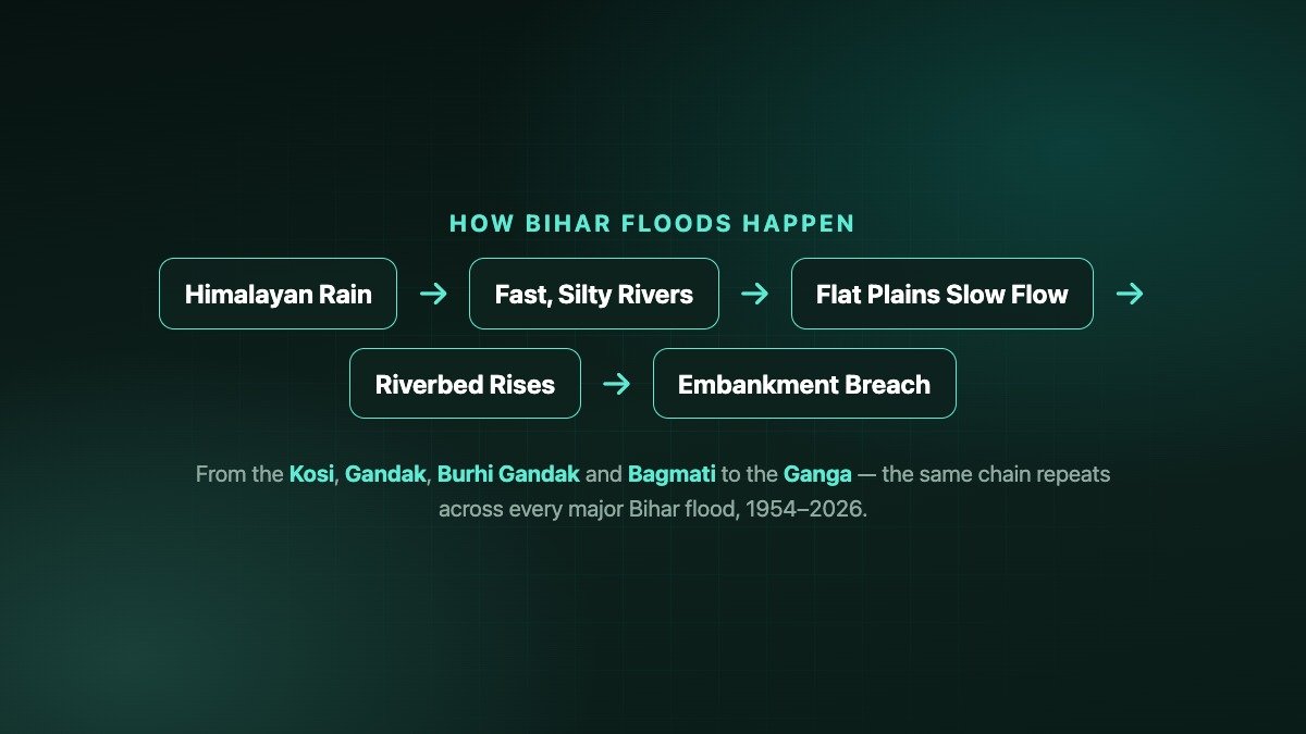
Why Bihar Floods Every Year
The same basic chain repeats across nearly every major Bihar flood
- Bihar’s northern rivers — Kosi, Gandak, Burhi Gandak, Bagmati and Kamla Balan — all originate in the young, geologically fragile Himalayas of Nepal, where steep terrain erodes easily during heavy rain.
- These rivers drop from mountain gradients onto the near-flat Gangetic plain within a short distance, losing the speed needed to carry their heavy sediment load any further.
- The dropped silt settles inside the riverbed itself, gradually raising the channel floor — a slow process that, over decades, can leave a river flowing above the level of the surrounding farmland.
- Embankments built to confine these rivers also confine that silt to a narrower channel, so the same siltation effect that would once have spread across the floodplain instead concentrates inside the embanked channel.
- When monsoon discharge from Nepal spikes faster than the state’s drainage network and embankments can handle, water either overtops an embankment or breaches it outright, releasing a sudden and often more destructive flood onto land that had been considered “protected.”
- All of this compounds when several rivers rise together, as happened in 2004 and again in September 2026, because the Ganga itself — the receiving channel for every northern tributary — is simultaneously running high and slowing everyone else’s drainage.
Bihar Flood Milestones at a Glance
| Year | Trigger river(s) | Scale | Why it mattered |
|---|---|---|---|
| 1954 | Kosi | Policy turning point, Kosi Agreement signed | Institutionalised embankment-led flood control |
| 1987 | Kosi / Bhote Kosi | 1,399 deaths, ~29M affected, 30 districts | First major challenge to the embankment-only model |
| 2004 | Bagmati, Burhi Gandak, Kamla Balan | 885 deaths, 21.3M affected, 20 districts | Showed multi-river flooding beyond the Kosi basin |
| 2008 | Kosi (Kushaha breach) | 3.3M affected, 500+ deaths | Bihar’s most destructive single flood event |
| 2017 | Gandak, Bagmati, Kosi and others | 514 deaths, 17.1M affected, 19 districts | Deadliest recent flash-flood year |
| 2026 | Ganga, Gandak, Kosi, Burhi Gandak | ~10.26 lakh affected, 11 districts (as of 5 Sept) | Ganga set a new historic level at Patna |
Embankments and the Silt Problem
Why Bihar’s biggest flood defence is also part of the debate
Since the 1954 Kosi Agreement, embankments have been Bihar’s central flood-control tool: their combined length grew from about 160km in 1952 to roughly 3,430–3,465km by 1999–2002, an almost 22-fold increase in under half a century.
But hydrologists have long pointed to a paradox in the state’s own data: over that same period, Bihar’s officially flood-prone area did not shrink — it grew, from about 2.5 million hectares in the 1950s to roughly 6.88 million hectares by 2010, per the Water Resources Department. Embankments confine a river’s water, but they also confine its silt to a narrower channel, letting the riverbed itself rise above the surrounding land over the decades. When such a channel eventually overtops or breaches — as at Kushaha in 2008 — the flood can be more sudden and more destructive than an unembanked river’s more gradual, dispersed overflow would have been.
This is why Bihar’s current disaster-management approach increasingly pairs embankments with early-warning systems, real-time river telemetry and (still-debated) basin-wide sediment management, rather than treating embankment length alone as a measure of flood safety.
| Metric | ~1952 | ~1999–2010 |
|---|---|---|
| Embankment length in Bihar | ~160km | ~3,430–3,465km |
| Bihar’s flood-prone area | ~2.5 million hectares | ~6.88 million hectares |
| Districts classified flood-prone (of 38) | fewer, pre-expansion data limited | 28 of 38 |
The 2026 Situation: Ganga, Kosi and Burhi Gandak
As reported on 5 September 2026 — check live Bihar WRD/CWC bulletins for the current position
What is verified as of 5 September 2026: The Ganga at Gandhi Ghat, Patna reached 50.53 metres on Saturday morning — one centimetre above the river’s previous highest flood level of 50.52 metres, and well above the 48.60 metre danger mark. Forecasts at the time expected the level to rise further, toward 50.62 metres, by Sunday morning.
Other rivers above danger level the same day: the Gandak at Dumaria Ghat and Hajipur; the Kosi at Baltara and Kursela; the Burhi Gandak at Khagaria; the Bagmati; the Punpun at Sripalpur; and the Ghaghra at Darauli — eight major rivers flowing above their danger marks in total, per state government reporting.
Scale and response: Around 10.26 lakh people across 11 districts (Patna, Vaishali, Bhojpur, Bhagalpur, Khagaria, Purnea, Madhepura, Saharsa and Katihar among them) were reported affected. The state deployed 27 SDRF teams and 9 NDRF teams, distributed roughly 12,300 polythene sheets and 2,250 dry-ration packets, ran 38 community kitchens and used 858 boats for rescue and relief.
What is not yet confirmed: No official state-wide death toll for this event had been released as of this update. September 2026 rainfall in Bihar ran about 69% above normal (60.8mm for the month at the time of reporting), which is the underlying driver of the rapid river rise. Because this is a live, evolving situation, treat every figure in this section as time-stamped to 5 September 2026, not as a final tally.
Explore More Timelines
People Also Ask
Frequently Asked Questions
Explore More on AiTimeline
⚠️ Editorial Note
This article separates verified official and institutional figures (Bihar Water Resources Department, Central Water Commission, GFDRR/World Bank, government district-level flood tallies, and contemporaneous news reporting from outlets including Business Standard, The Week and The Federal) from general background context. Historical death tolls, especially for 1987, 2004 and 2017, come from government figures reported in the aftermath and may differ slightly across sources; figures for the ongoing September 2026 flood are provisional and will be updated as official confirmation becomes available. This is editorial content, not emergency-management guidance — residents in flood-affected areas should follow instructions from local district administration and the Bihar Disaster Management Department directly.
Sources & further reading
Every dated entry above was checked against these references. Last reviewed 15 September 2026.
- GFDRR / World Bank — Bihar Kosi Flood Needs Assessment (2008)
- World Bank — $220 million for Kosi flood-affected areas in Bihar
- Bihar Water Resources Department — Flood Management Information System
- International Water Law Project — 1954 Kosi Agreement (India-Nepal)
- The Week — Bihar on high alert as Ganga crosses danger mark (5 Sept 2026)
- Wikipedia — 2017 Bihar flood
- Wikipedia — 1987 Bihar flood