Himalayan Glacier Disaster Timeline 2026–2050: GLOFs, Floods & Hydropower Risk
Track Himalayan glacier disasters from 2021-2050: Nepal's 2026 glacier collapse, India's high-risk glacial lakes, GLOFs and hydropower exposure.
Latest Story
On August 26, 2026, a mass of ice and rock collapsed high above Nepal’s Langtang region, sending a debris-laden flood down the Bhote Koshi and Trishuli rivers that has since killed more than a thousand people. It was not the Himalayas’ first warning, and scientists say it will not be the last. Climate change does not create one Himalayan hazard — it feeds several at once: retreating glaciers, expanding glacial lakes, thawing permafrost and unstable slopes, each capable of triggering a glacial lake outburst flood (GLOF), an ice-rock avalanche, or a debris-flow disaster of its own. This page tracks what has actually happened, what is currently being monitored, and what remains a modelled projection — through 2050 — without turning a risk assessment into a predicted disaster date.
Data last verified: 2 September 2026. Casualty figures for the Nepal-Tibet disaster change quickly and are timestamped throughout. A glacial lake being “high-risk” is a monitoring classification, not a prediction that it will fail. This article does not predict specific future disasters, dam failures or conflicts.
One week after the Langtang glacier collapse, Nepal’s death toll has passed 1,100
The disaster began on August 26, 2026, when a large section of glacier and surrounding rock detached near Nepal’s Langtang region and fell roughly 1,200 metres into the valley below. The resulting debris flood — estimated at 100–200 million cubic metres of ice, rock, sediment and water — surged down the Bhote Koshi and, downstream, the Trishuli river system at speeds of roughly 50 metres per second (~180 km/h), reaching the Nepal-China border crossing at Gyirong Port about 7 minutes after the initial seismic signal. As of September 1–2, Nepali authorities have confirmed 1,114 deaths and 3,916 people still missing; China has confirmed 16 deaths and 546 missing on the Tibet side. Rescue operations continue in both countries. Casualty figures are changing quickly and are tracked in the status dashboard below.
🧠 AI Overview Summary
The August 26, 2026 Nepal-Tibet disaster is understood primarily as a glacier and ice-rock collapse, not a classic glacial lake outburst flood (GLOF). Roughly 1,200 metres of ice, rock and sediment fell into a valley, triggering a flash flood that has killed over 1,100 people in Nepal (1,114 confirmed dead, 3,916 missing as of September 1–2) and damaged about 431 MW of grid-connected hydropower capacity — roughly 10% of Nepal’s total — plus another ~470 MW of under-construction capacity. It follows a pattern of accelerating Himalayan risk: ICIMOD says regional glacier ice-loss rates have roughly doubled since 2000, a 2026 Himachal Pradesh study flagged 88 glacial lakes as at-risk, and India now tracks around 195 high-risk glacial lakes nationally. None of this means a specific lake, dam or city is destined to flood — it means the Himalayan system is changing faster than in previous decades.
How to read this page
Every claim below is labelled by evidence level — this page never upgrades a monitored risk into a predicted disaster.
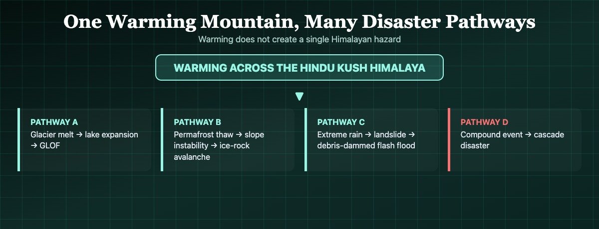
Warming does not create one Himalayan hazard — it can feed glacier retreat, glacial lake growth, permafrost degradation and rock/ice instability at the same time, each of which can independently trigger a GLOF, an ice-rock avalanche, a landslide-dammed flood, or a compound cascade of more than one. Distinguishing which is which — and what is actually happening versus modelled — is the point of this page.
Himalayan Glacier Risk: Key Questions
What’s actually established vs. still developing
- Aug 26, 2026: A glacier/ice-rock collapse near Nepal’s Langtang region, not a classic GLOF, triggered a flash flood that has killed 1,114+ people in Nepal and 16 in Tibet as of Sept 1-2, with thousands still missing.
- Hydropower hit hard: Nepal lost 431 MW of operating capacity plus ~470 MW under construction, forcing a temporary switch from power exporter to importer.
- Not every disaster is a GLOF: Chamoli (2021) was a rock-ice avalanche, South Lhonak (2023) a classic GLOF, Nepal (2026) a glacier collapse — three distinct mechanisms.
- Glaciers are shrinking faster: ICIMOD’s March 2026 assessment found HKH ice-loss rates have roughly doubled since 2000, based on 38 monitored glaciers.
- Lakes are growing, but selectively risky: a 2026 Himachal Pradesh study flagged 88 lakes as at-risk out of a far larger regional population — not all glacial lakes are dangerous.
- India tracks ~195 high-risk lakes nationally out of thousands mapped; that is a monitoring list, not a failure forecast.
- Hydropower exposure is real but not doom: ~66% of sampled projects sit on a potential GLOF track, but exposure does not equal guaranteed failure.
- “Peak water” is a mid-century range (2030-2050), not a single date — and it means changing timing and seasonality of water, not rivers disappearing.
- Transboundary coordination is improving but incomplete: Nepal sought more real-time data from China in May 2026; both sides describe partial, not zero, cooperation.
- 2050 and 2100 figures here are modelled scenarios, never treated as dated predictions of a specific future disaster.
August 26, 2026: The Langtang glacier collapse
🟢 Observed event · classification still developing.
Satellite imagery identified a major release of ice, rock and sediment from a slope near Nepal’s Langtang region, falling from an elevation of roughly 5,200–5,400 metres to the valley floor about 1,200 metres below — an estimated 100–200 million cubic metres of material. The impact and resulting debris entered the Lhende Khola and dammed it, and the ice-rock-water mass surged into the Bhote Koshi and, further downstream, the Trishuli river system at roughly 50 metres per second (~180 km/h), with floodwater reaching an elevation of about 800 metres in a valley some 7 kilometres from the collapse site. A secondary debris-dammed barrier lake (roughly 2 million cubic metres) formed after the collapse; it drained and was largely empty by August 30. A separate, smaller lake higher on the mountain, near the collapse site itself, remains under watch.
USGS determined the seismic energy detected around the time of the collapse (magnitude ~5.2) was generated by the mass movement itself, not a conventional tectonic earthquake. Climate warming is considered an important background factor in the region’s growing instability, but this article does not claim warming caused this specific collapse with certainty — that requires a dedicated attribution study, which had not been published as of this update.
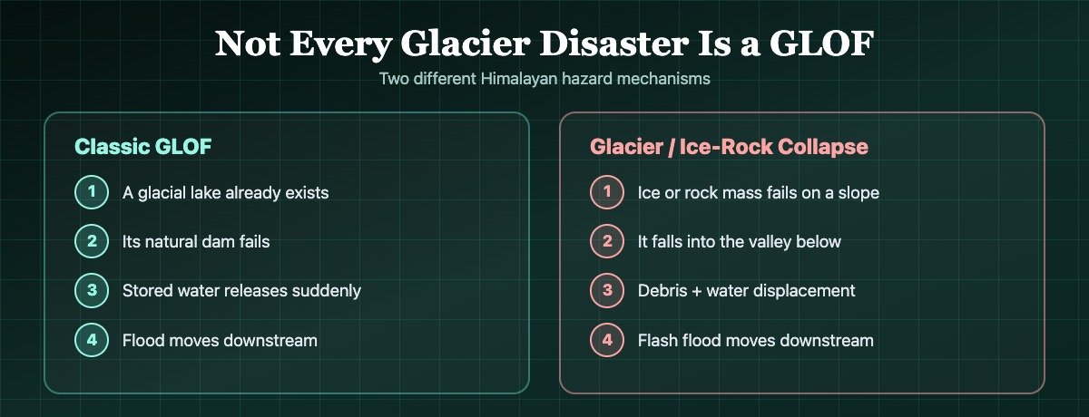
Not every glacier disaster is a GLOF
The August 2026 Nepal event is currently classified as a glacier/ice-rock collapse, not a classic pre-existing-lake GLOF.
Classic GLOF
- A glacial lake already exists
- Its natural moraine or ice dam fails
- Stored water is released suddenly
- Flood moves downstream
Glacier / ice-rock collapse
- An ice or rock mass fails on a slope
- It falls into a valley below
- Debris and displaced water combine
- Flash flood moves downstream
The distinction matters because Himalayan climate risk is broader than glacial lakes alone. South Lhonak in Sikkim (2023) is a textbook GLOF — a lake breached its natural dam. The August 2026 Nepal event did not require a pre-existing lake to fail first; the mountain slope itself gave way. A secondary debris-dammed lake formed only after the collapse, as an added consequence rather than the initial trigger.
One warming mountain, many disaster pathways
Warming can feed several different hazard chains at once — not a single predictable failure mode.
Two Himalayan disasters, two different mechanisms
Same warming mountains, different failure modes.
| Event | Sikkim, October 2023 | Nepal-Tibet, August 2026 |
|---|---|---|
| Mechanism | Glacial lake (South Lhonak) breach — classic GLOF | Glacier/ice-rock collapse — not a classic pre-existing-lake GLOF |
| Trigger | Lateral moraine failure into the lake | Slope failure high above the valley |
| Downstream chain | Teesta basin flood, Teesta III dam destroyed | Bhote Koshi/Trishuli flash flood, ~431 MW hydropower damaged |
| Secondary lake risk | Not applicable | Debris-dammed barrier lake formed after the collapse |
| Classification confidence | 🟢 Well-established GLOF | 🟡 Collapse confirmed; full mechanism still under study |
Himalayan glacier disaster timeline, 2021–2050
Newest first. 🟢 observed · 🟡 monitored · 🟠 modelled/projected · ⚪ scenario.
Rescue operations continue; hydropower reassessment begins
Status: Nepal’s confirmed death toll has reached 1,114, with 3,916 people still missing; China has confirmed 16 deaths and 546 missing in the Tibet Autonomous Region. Rescue operations continue in both countries. Nepal’s electricity authority has begun assessing damaged plants (Rasuwagadhi, Chilime, Trishuli 3A and 3B, Devighat among them); the country temporarily suspended power exports and drew imports from India.
The Langtang glacier collapse and Nepal-Tibet flood
What happened: A large section of glacier and rock detached and fell ~1,200m (100-200 million m³ of material), damming the Lhende Khola and triggering a debris-laden flash flood down the Bhote Koshi and Trishuli rivers at roughly 50 m/s, reaching the Gyirong Port border crossing about 7 minutes after the seismic signal.
Infrastructure impact: Roads, bridges and hydropower plants were damaged across the corridor; Nepal lost 431 MW of operating hydropower capacity and saw a further ~470 MW of under-construction capacity damaged.
Himachal Pradesh’s glacial-lake risk screening
A joint study (published August 28, 2026) screened Himachal Pradesh’s glacial lakes and flagged 88 as being at risk — 9 classified extremely hazardous, 18 very highly hazardous, 26 hazardous, and the remainder in lower-hazard tiers. Separately, satellite (LISS-4) mapping has counted 2,292 glacial lakes in the Sutlej basin alone, and basin-level studies elsewhere in Himachal (Satluj, Chandra) have documented lake frequency and area growing by double- and triple-digit percentages since the 1990s.
Himalayan snowpack hits a record low
ICIMOD reported HKH-wide snow persistence roughly 27.8% below the long-term average — the fourth consecutive below-normal year. Water security depends on snow as well as glaciers, and a low-snow year does not by itself mean low flood risk: warmer, drier stretches interrupted by short intense rainfall can still raise flash-flood and landslide risk.
ICIMOD: Himalayan glacier ice-loss has roughly doubled since 2000
ICIMOD’s HKH Glacier Outlook, released March 21, 2026 and based on 38 continuously monitored glaciers, found glacier ice-loss rates across the Hindu Kush Himalaya have roughly doubled since 2000, with monitored sites losing about 27 metres of ice thickness since 1975 and the region losing roughly 12% of glacier area and 9% of ice reserve between 1990 and 2020. This is a distinct metric from the earlier “mass loss accelerated ~65% faster in the 2010s than the 2000s” finding — the two should not be merged into one number.
Thame, Nepal — a two-lake GLOF cascade
Scientists linked flooding at Thame village to a glacial lake outburst, with reporting describing a cascade involving more than one upstream lake. It illustrates that GLOFs are a recurring, not one-off, feature of the region’s changing cryosphere.
South Lhonak GLOF hits Sikkim
A lateral moraine failure at South Lhonak Lake released a large volume of water into the Teesta basin, destroying the Teesta III hydropower dam and causing major downstream devastation. This is the clearest classic GLOF in this timeline — a pre-existing lake, a dam failure, a sudden release.
Chamoli disaster, Uttarakhand
A large rock-ice avalanche near Ronti Peak triggered a debris flow and flood that destroyed hydropower infrastructure and caused major loss of life. Peer-reviewed analysis classified this as a rock-ice avalanche, not a classic GLOF — no glacial lake dam failure was the initiating mechanism.
Expanded monitoring and early-warning systems
India’s National GLOF Risk Mitigation Project and state-level lake-monitoring programs are expected to expand risk assessment, sensor networks and early-warning coverage across Himalayan states in this window, building on work already under way in Sikkim, Himachal Pradesh, Uttarakhand and Ladakh.
Hydropower design adaptation
Following Sikkim’s Teesta III collapse and India’s CWC decision to review design floods for GLOF-exposed dams, this decade is likely to see design-flood standards, catchment risk studies and dam-safety rules evolve for existing and new Himalayan hydropower — not a prediction of which specific projects will be built or fail.
Peak-water transition, at a regional scale
ICIMOD’s HI-WISE regional assessment projects the Indus, Ganges and Brahmaputra basins reaching “peak water” — the point of maximum glacier meltwater contribution to river flow — somewhere in the 2030-2050 window, before dry-season flows from glacier melt begin to decline. The range, not a single date, is the point: timing varies by basin.
Larger glacier-volume loss under continued warming
Under a high-emissions (~4°C) warming pathway, ICIMOD’s HI-WISE assessment estimates the HKH could lose up to roughly 80% of current glacier volume by 2100. This is a scenario tied to future emissions, not a fixed forecast — a lower-emissions pathway would leave substantially more ice intact.
Glacial lakes are growing — but risk screening is selective
🟢 Himachal Pradesh case study, IIT Ropar / University of Technology Sydney, published August 28, 2026.
Rapid lake growth across Himachal Pradesh’s river basins is real and well-documented in satellite mapping — but growth in lake count or area is not the same as “about to burst.” The 88 lakes this study flagged at-risk (split across three hazard tiers) are a screened, prioritized subset of a much larger regional lake population that runs into the thousands once every basin is counted. Treat any single Himachal-wide percentage-growth headline with caution unless it cites a specific, checkable study — this section deliberately sticks to figures traced to a named source.
India isn’t only mapping the risk — it’s building warning technology
🟢 Government of India / NDMA / state disaster-management figures.
| Region | Glacial lakes inventoried | Classified high-risk |
|---|---|---|
| India (national, NDMA) | Thousands mapped by NRSC; hundreds monitored seasonally by CWC | ~195, on a dynamic high-risk list |
| Ladakh | 3,219 lakes >0.25 hectares (July 2026 inventory) | Risk-modelled for select lakes, e.g. Katkar, Suru |
| Sikkim | ~320 glacial lakes | 14 identified high-risk (2026) |
India’s roughly 195 high-risk lakes — expanded over time from an initial screening of 56 — are a priority-monitoring subset of a much larger inventory of thousands of mapped lakes nationally, not the entire glacial-lake population. Being on the list means a lake shows rapid growth or other GLOF-susceptibility characteristics, not that it is expected to fail. Some current reporting still cites an earlier count of 189; this article uses the more recent 195 figure while noting both numbers circulate. Recent reporting sometimes rounds the figure to “approximately 200” or references a separate, broader regional ICIMOD count of roughly 200 dangerous HKH lakes; these are related but distinct datasets and should not be combined into one number.
National GLOF Risk Mitigation Project
An approved outlay of roughly ₹150 crore (~$20 million), reported to cover high-risk Himalayan states including Arunachal Pradesh, Himachal Pradesh, Sikkim and Uttarakhand, funding risk assessment, monitoring, early warning, mitigation works and community preparedness.
CWC design-flood review
Following the October 2023 South Lhonak/Teesta III disaster, India’s Central Water Commission moved to review design floods for existing and under-construction dams vulnerable to GLOFs, and GLOF studies are now required for new dams with glacial lakes in their catchment.
Sikkim’s indigenous lake monitoring
Sikkim has built indigenous glacial-lake monitoring capability, combining satellite tracking, bathymetry and automated risk profiling to support its 14 identified high-risk lakes (a July 2026 state figure) — other classifications using different hazard-tier criteria put Sikkim’s high-priority lake count higher, so treat the exact number as criteria-dependent.
Satellites, sensors & hydrology
NRSC satellite mapping, CWC seasonal river-gauge monitoring, IoT lake-level sensors and hydrological modelling together form India’s layered glacial-lake watch — not any single tool alone.
When a glacier disaster becomes an energy crisis
Nepal’s 2026 flood turned a climate hazard into an immediate power-grid problem.
Nepal relies heavily on hydropower for both domestic electricity and export revenue. The Nepal Electricity Authority reported the August 2026 flood knocked roughly 431 MW of operating generation capacity offline — about 10% of the national total, including plants at Rasuwagadhi, Chilime, Trishuli 3A/3B and Devighat — with a further ~470 MW of under-construction capacity also damaged, forcing Nepal to temporarily suspend electricity exports and draw imports from India. That converts a climate/geological hazard directly into an energy, trade and development problem, not just a disaster-relief one.
| Infrastructure risk | What the evidence actually shows | Why it matters |
|---|---|---|
| GLOF exposure | A Monte Carlo modelling study of 257 sampled Himalayan hydropower projects found 66% sit on a potential GLOF flow track | Location, not automatic failure, drives exposure |
| Design-flood exceedance | Up to roughly one-third of exposed projects could see modelled GLOF discharges above their local design-flood capacity | Older design assumptions can be challenged by a changing cryosphere |
| Nepal, Aug 2026 | 431 MW operating capacity lost + ~470 MW under-construction damaged, ~10% of national total | This risk is already materializing, not hypothetical |
| Sikkim, Oct 2023 | Teesta III severely damaged/destroyed by the South Lhonak GLOF | A GLOF can trigger cascading infrastructure failure |
| Outlook | Risk is likely to keep evolving as glaciers, lakes and slopes change | Historical flood records may understate future extremes |
A 50-year dam meets a mountain that no longer looks like it did when the dam was designed.
None of this makes Himalayan hydropower automatically unsustainable. It provides electricity, low-carbon power, energy security and export revenue for mountain economies that need all four. The better question is not whether hydropower should exist in the Himalayas, but where projects are sited, how they are designed, what hazards are modelled, and how early warning is built in — can Himalayan hydropower be built for a climate that no longer looks like the past?
Water crosses borders faster than governments can negotiate
The Himalayan river systems affected by this risk run through India, Nepal, China, Bhutan, Pakistan, Bangladesh and Myanmar.
A hazard that begins upstream in one country can become a downstream emergency in another within minutes, not days. That makes Himalayan glacier and glacial-lake monitoring a matter of regional coordination as much as national policy — satellite data, river gauges and early-warning messages carry cross-border weight that ordinary infrastructure does not.
⚠️ Nepal-China data sharing after the August 2026 disaster
Reuters reported that Nepali and Chinese officials met in Kathmandu on May 27, 2026 and agreed to strengthen cooperation on glacial-lake inventories and hazard mapping. Two Nepali officials later told Reuters they did not receive as much data as they had wanted after that meeting, and worried this could hamper disaster preparedness. Separately, China’s World Meteorological Centre had emailed Nepali officials a monsoon-depression forecast on August 14-19 — twelve days before the disaster. China’s embassy says the two sides made “substantial progress” on cross-border data sharing at the May meeting.
What is and isn’t established: This is a genuine, reported disagreement about the adequacy of existing arrangements — it is not established that China “failed to warn” Nepal, and this article does not characterize it as a diplomatic conflict. The more accurate framing: the disaster renewed questions about whether existing cross-border monitoring and warning arrangements are sufficient for fast-moving Himalayan hazards.
There is no single unified China-India-Nepal Himalayan glacier-risk treaty; different river basins operate under different bilateral agreements and data-sharing arrangements. That is not the same as “zero cooperation” — it means transboundary hazards make continued, real-time coordination increasingly important as monitoring and warning technology improves through 2030-2050, rather than pointing toward any specific future dispute.
How does a GLOF actually happen?
Many high-altitude Himalayan lakes are held back not by engineered concrete dams but by loose glacial sediment (moraine) or ice. That is why a rockfall, avalanche or earthquake elsewhere on the slope can trigger a failure with little local warning. Beneath many unstable slopes lies a second, less visible factor: permafrost, ground that stays frozen for at least two consecutive years. As it thaws, ice within rock cracks and soil can melt, and some slopes can become less stable — a process already under way in parts of the HKH, though there is no single scientifically established “critical threshold” date for the whole Himalaya, and this article does not claim one.
2050: the Himalayas face a water-timing problem, not a fixed deadline
🟠 Modelled · the 2050 horizon is an outlook, not a disaster date.
What the science supports
- More water first, as melt accelerates in the near term
- ICIMOD’s HI-WISE assessment projects the Indus, Ganges and Brahmaputra basins reaching peak water somewhere in the 2030-2050 window
- Under a high-emissions pathway, up to ~80% of current HKH glacier volume could be lost by 2100
- Timing, seasonality and variability of water are the real mid-century issue
What the science does NOT support
- “Himalayan rivers permanently dry up by 2050”
- A single universal peak-water year for the whole Himalaya
- “One billion people will lose water in 2050”
- Ganges or Brahmaputra flow depending primarily on glaciers
River systems originating in or fed by the Hindu Kush Himalaya support nearly two billion people across Asia — but that does not mean nearly two billion people drink glacier meltwater directly. Dependence on glacier melt varies enormously by basin, season and altitude: the Indus basin is relatively snow-and-glacier-sensitive, especially seasonally, while the Ganges and Brahmaputra are dominated by monsoon rainfall, with snow and glacier melt as important but secondary contributors, particularly upstream. Under a high-emissions warming pathway, ICIMOD’s HI-WISE assessment estimates the HKH could lose up to roughly 80% of current glacier volume by 2100 — useful context for the 2050 horizon, without letting 2100 dominate a page framed around 2050. A lower-emissions pathway would leave substantially more glacier volume intact; this article does not cite a single precise loss figure for that scenario, since the exact number is scenario- and study-dependent.
Can technology prevent a GLOF disaster?
It cannot stop glaciers from melting — but it can shorten the gap between hazard and warning.
In steep Himalayan valleys a flood wave can move within minutes of a trigger, as the ~9-metre, 30-minute river rise in August 2026 showed. A sensor without a “last-mile” alert reaching the people downstream is not enough — effective systems need automated detection, communications infrastructure and rehearsed community evacuation plans working together, not any single layer alone.
Why the danger can begin far above the people who experience it
The August 2026 disaster showed why Himalayan risk cannot be reduced to a map of glacial lakes. No lake needed to burst first — the mountain itself failed. A mass of ice and rock high above the valley collapsed, accelerated downslope and entered a river system already capable of carrying enormous energy. Downstream communities had minutes, not hours, to understand what was happening. That is the frightening feature of the new Himalayan risk landscape: the hazard can begin far above the people who eventually experience it.
Hydropower illustrates the region’s climate dilemma as clearly as anything else. The same rivers that make the mountains dangerous also make them valuable. Nepal needs those rivers for electricity; India needs more low-carbon power; mountain economies need roads, bridges and development. But that infrastructure is being built inside valleys whose glaciers, rainfall and slopes are changing. The question is not whether Himalayan hydropower should exist — it is whether infrastructure designed for yesterday’s mountain can survive tomorrow’s.
Himalayan risk matrix: 2026 evidence vs mid-century outlook
| Threat | 2026 evidence | Mid-century risk |
|---|---|---|
| Glacier loss | ICIMOD: ice-loss rate roughly doubled since 2000 (38 monitored glaciers) | Continued glacier-volume decline, pace varies by basin |
| Glacial lakes | Himachal study flags 88 at-risk lakes; India tracks ~195 high-risk lakes nationally | More/new lakes possible as glaciers retreat further |
| GLOFs | Sikkim 2023 demonstrates destructive potential | Risk expected to rise in many catchments — not every lake will fail |
| Glacier collapse | Nepal 2026 shows hazards extend beyond GLOFs | Warming/permafrost change may increase some slope-instability risks |
| Hydropower | Nepal lost 431 MW operating + ~470 MW under-construction in the 2026 flood | Design and siting need updated hazard assumptions |
| Water supply | HKH snow persistence 27.8% below average in 2026 | Peak-water/seasonal-flow shifts expected around mid-century |
| Transboundary warning | Nepal-China disaster renewed data-sharing questions | Regional monitoring coordination becomes increasingly important |
💡 Discover: things worth knowing
- The Hindu Kush Himalaya holds the largest concentration of ice outside the polar regions, and feeds river systems supporting nearly two billion people across Asia (ICIMOD).
- The 2026 Nepal disaster followed the same Rasuwagadhi corridor as an earlier, smaller July 2025 supraglacial-lake flood on the same route.
- “High risk” on India’s glacial-lake list is a monitoring-priority classification, not a burst prediction — most listed lakes have never failed.
- Peak water does not mean rivers vanish — it means the glacier’s contribution to river flow eventually declines as the ice itself shrinks.
- Not every Himalayan flood after a glacier event is a GLOF; ice-rock avalanches, landslide dams and compound cascades are separate, real mechanisms.
Explore More Timelines
People also ask
Frequently asked questions
Related AiTimeline coverage
⚠️ Editorial Note
This article separates observed events, currently monitored risks, modelled/projected scenarios and genuinely uncertain outcomes throughout — look for the color-coded tags. Casualty and damage figures for the August 2026 Nepal-Tibet disaster change quickly; the figures here are timestamped to September 2, 2026 and will be updated as more verified reporting becomes available. This is editorial, AI-assisted content compiled from publicly available sources and does not constitute emergency guidance, engineering advice, or a prediction of any future disaster, dam failure or diplomatic dispute.
Sources & further reading
Every dated entry above was checked against these references. Last reviewed 15 September 2026.
- ICIMOD - Hindu Kush Himalaya glaciers losing ice at double the rate since 2000 (March 2026)
- ICIMOD - New study confirms climate change played a key role in the 2023 Sikkim lake outburst
- ICIMOD - GLOF from Thyanbo glacial lake sweeps away Thame Village (2024)
- Shugar et al. 2021 - A massive rock and ice avalanche caused the 2021 disaster at Chamoli (Science)
- A massive lateral moraine collapse triggered the 2023 South Lhonak Lake outburst flood (Landslides, 2024)
- Stimson Center - Transboundary glacial floods on the China-Nepal border (Rasuwa 2025)
- Al Jazeera - Nepal-Tibet floods: what happened, what caused them and who is missing
- USGS - Landslide Hazards Program