← AiTimeline Home

🌋 Krakatoa Awakens · Updated 6 September 2026

Krakatoa Eruption Timeline 1883-2026: Anak Krakatau, Tsunamis and Major Eruptions

📅 Updated 6 September 2026Reuters, NOAA, PVMBG & Science Advances sourced reportingNot an official alert — check PVMBG/BNPB for live warnings
Advertisement

View as Web Story

In short

Explore the Krakatoa eruption timeline from the 1883 catastrophe to Anak Krakatau, the 2018 tsunami, later eruptions and the 2026 ash disruption in Indonesia.

Latest Story

In August 1883, Krakatoa’s eruption became one of the most violent volcanic disasters in recorded history, destroying most of the island and sending deadly tsunamis crashing into the coasts of Java and Sumatra. But the story did not end when the island exploded. A new volcanic island, Anak Krakatau — “Child of Krakatoa” — later rose from the same caldera and has kept growing and erupting ever since. In September 2026, volcanic ash from Anak Krakatau disrupted flights around Jakarta, while Indonesian disaster authorities said there was no immediate tsunami threat. This Krakatoa timeline traces both stories — the ash hazard confirmed in 2026, and the tsunami hazard that remains closely watched but separate.

⚠️ What this article is — and is not. This is an educational, source-backed explainer of Krakatoa’s 1883 eruption and Anak Krakatau’s activity through 2026. It is not an official hazard alert. For real-time eruption status, exclusion zones or tsunami warnings, always check Indonesia’s Geological Agency (PVMBG/MAGMA Indonesia), BNPB or BMKG directly — this article does not predict future eruptions and does not claim the 2026 activity is causing a tsunami.

🧠 Short Answer: Why Is Anak Krakatau Still Dangerous?

Anak Krakatau is dangerous because it is an active volcanic island in Indonesia’s Sunda Strait, between Java and Sumatra. Its eruptions can produce ash clouds, lava and aviation hazards. In 2018, part of its flank collapsed into the sea and triggered a deadly tsunami. In 2026, the main reported disruption was volcanic ash affecting flights, with authorities saying there was no immediate tsunami threat.

⚡ Krakatoa & Anak Krakatau Quick Facts
1883 eruption26-27 August 1883, Sunda Strait, Indonesia
1883 death tollOfficial Dutch count: 36,417 (NOAA)
Anak Krakatau bornLate 1927, inside the 1883 caldera (Smithsonian GVP)
2018 tsunami deaths437 confirmed, no earthquake trigger (BNPB)
July 2026 alertRaised to Level III (Siaga), 3km exclusion zone
September 2026209 flights hit, ash to ~50,000ft, no tsunami threat (Reuters)
⚡ Quick Answers — AI Overview Ready

Krakatoa & Anak Krakatau: Key Questions

Why is Anak Krakatau still dangerous?
It is an active volcanic island in the Sunda Strait whose eruptions can produce ash, lava and aviation hazards. A 2018 flank collapse triggered a deadly tsunami; the 2026 eruption’s main confirmed hazard was ash, with authorities reporting no immediate tsunami threat.
What actually happened at Anak Krakatau in September 2026?
Reuters reported that eruptions in early September 2026 sent ash plumes up to roughly 50,000 feet, forcing Jakarta’s Soekarno-Hatta Airport to suspend flights, affecting 209 flights. Indonesian disaster officials said there was no immediate tsunami risk from the activity.
Is Krakatoa the same volcano as Anak Krakatau?
No. Krakatoa (Krakatau) is the older volcanic island complex destroyed in the catastrophic 1883 eruption. Anak Krakatau is a newer island that emerged from the sea inside the same caldera in late 1927 and has been active ever since.
Did the 2018 tsunami and 2026 eruption have the same cause?
No. The December 2018 tsunami was caused by a sudden collapse of Anak Krakatau’s flank into the sea. The September 2026 disruption was an ash-and-aviation event; officials reported no comparable flank collapse or tsunami risk this time.
📚 Key Takeaways

Krakatoa and Anak Krakatau, in eight points

  • Krakatoa’s 1883 eruption destroyed much of the volcanic island and generated deadly tsunamis.
  • Anak Krakatau means “Child of Krakatoa” and emerged from the sea in the caldera left by the 1883 eruption.
  • The 2018 Sunda Strait tsunami was linked to a flank collapse of Anak Krakatau.
  • The 2026 eruption caused major ash disruption, including flight suspensions around Jakarta.
  • Reuters reported ash plumes reaching up to about 50,000 feet and 209 flights affected.
  • Authorities said the 2026 eruption presented no immediate tsunami threat.
  • Ash clouds are especially dangerous for aviation because volcanic ash can damage aircraft engines and windshields.
  • This article separates four distinct hazards: eruption, flank collapse, tsunami and ash-cloud risk — they are not the same thing.

Where Is Krakatoa?

Anak Krakatau sits in the Sunda Strait, between Java and Sumatra, roughly 155km west of Jakarta.

🗺️ Locator — Schematic, Not to Scale

SumatraLampung coastJavaBanten coast🌋 Anak KrakatauSunda StraitJakartaSoekarno-Hatta Airport← Indian OceanJava Sea →

Alt text: Locator map showing Anak Krakatau in the Sunda Strait between Java and Sumatra, near Jakarta and Indonesia’s main airport. Diagram is a simplified schematic, not a precise geographic map.

Krakatoa Eruption Timeline: 1883-2026

From the 1883 catastrophe to Anak Krakatau’s latest ash disruption.

1883

Krakatoa Catastrophe

26-27 August 1883Sunda Strait, Java-Sumatra

What happened: Krakatoa erupted catastrophically over 26-27 August 1883 in the Sunda Strait. A series of explosions climaxed on the morning of 27 August, destroying much of the island and generating tsunamis that struck the coasts of Java and Sumatra, becoming one of the deadliest volcanic disasters in recorded history.

Why it matters: Per NOAA, the final blast is considered the loudest sound in recorded history, reportedly heard over 4,600km away near Rodrigues Island, and its atmospheric pressure wave circled the globe multiple times, recorded on barographs worldwide for days.

Interesting fact: the eruption’s ash and aerosols caused vivid red sunsets around the world for months afterward and cooled global temperatures by roughly half a degree Celsius the following year.
~36,417 deaths (NOAA)Loudest sound on record
Late
1883

The Island Is Reshaped

Post-eruption surveyNew caldera formed

What happened: The eruption changed the geography of the Krakatoa island group. Much of the old volcanic structure collapsed into a submarine caldera, leaving behind only fragments of the original island — principally the remnant now known as Rakata — and a dramatically altered map of the strait.

Why it matters: The caldera left behind became the exact space where a new volcano would later be born — setting up the next chapter of the same volcanic system.

Interesting fact: for more than four decades after 1883, the caldera showed signs of continuing submarine volcanic activity before a new island ever broke the surface.
Two-thirds of island lost

Anak Krakatau Emerges

Late 1927Smithsonian Global Volcanism Program

What happened: Anak Krakatau — “Child of Krakatoa” — emerged from the sea in late 1927, rising from the same caldera left by the 1883 eruption. It was the next chapter of the same volcanic system, not a separate, unrelated volcano.

Why it matters: Every eruption discussed later in this timeline, including 2018 and 2026, happened at this same young island — not at the original 1883 Krakatoa, which no longer exists in its pre-1883 form.

Interesting fact: the new island broke the surface, was sometimes eroded back below sea level by waves, and re-emerged more than once before establishing itself permanently.
Born from the 1883 caldera
1930s-
2018

The Child Volcano Keeps Growing

40+ eruptive episodesSmithsonian GVP

What happened: Anak Krakatau continued erupting and building itself upward through repeated lava and ash activity across the 20th and early 21st centuries. Per the Smithsonian Global Volcanism Program, the volcano went through more than 40 recorded eruptive episodes between 1927 and December 2018, reaching a height of roughly 338 meters before that year’s collapse.

Why it matters: This decades-long buildup is what made the volcano tall and steep enough for a sudden flank failure to become possible in 2018.

Interesting fact: unlike many volcanoes that grow mainly from below, Anak Krakatau’s above-water cone was built almost entirely by eruptions after it first broke the surface in 1927.
~338m tall by 201840+ eruptions since 1927

Flank Collapse and Deadly Sunda Strait Tsunami

22 December 2018Ye et al. 2020, Science Advances

What happened: On the night of 22 December 2018, part of Anak Krakatau’s southwest flank collapsed into the sea during an ongoing eruption, displacing water and triggering a tsunami that struck the coasts of Banten (Java) and Lampung (Sumatra) with waves reported up to about 5 meters in places. There was no earthquake, so Indonesia’s seismically triggered tsunami-warning system did not detect it in advance.

Why it matters: This tsunami was caused by a volcanic flank collapse, not a typical earthquake-triggered tsunami — the peer-reviewed study by Ye and colleagues in Science Advances (2020) confirmed the collapse mechanism, and it remains the reason Anak Krakatau is treated differently from a “normal” eruption risk.

Interesting fact: because the collapse produced no seismic signal large enough to trigger existing tsunami sensors, some coastal residents had only minutes of warning, if any, before the waves arrived.
437 confirmed deaths (BNPB)No earthquake trigger

Monitoring and Repeated Eruptions

PVMBG close monitoringOngoing lava dome rebuild

What happened: After 2018, Anak Krakatau remained closely monitored by Indonesia’s Geological Agency (PVMBG). The volcano produced further eruptions and ash plumes in the years that followed, as its cone slowly rebuilt itself, reminding authorities that the volcano was still very much active.

Why it matters: The 2018 collapse did not end Anak Krakatau’s activity — it reset the volcano’s shape and restarted the same growth-and-eruption cycle that had been running since 1927.

Interesting fact: continuous monitoring during this period is part of why the July 2026 alert raise (below) could happen quickly once seismic activity picked up.
Continuous PVMBG monitoring

Alert Level and Ash Activity

2 July 2026PVMBG / Antara News

What happened: Indonesian authorities raised Anak Krakatau’s alert status from Level II (Waspada/Caution) to Level III (Siaga/Alert) on 2 July 2026, after a surge in volcanic earthquakes, ground deformation and shallow magma accumulation. A 3km exclusion zone was enforced, and the volcano recorded 19 separate eruptions between early June and mid-July 2026.

Why it matters: This alert raise, two months before the September ash event, shows the volcano’s unrest built up gradually and was actively tracked by officials — not a sudden surprise.

Interesting fact: Indonesia’s four-level alert scale (Normal, Waspada, Siaga, Awas) is a standard PVMBG framework used across the country’s roughly 120 active volcanoes, not something unique to Anak Krakatau.
Level III — Siaga3km exclusion zone

Ash Cloud Disrupts Jakarta Flights

4-6 September 2026Reuters / BNPB

What happened: Anak Krakatau’s eruption led to the suspension of flights at Jakarta’s Soekarno-Hatta International Airport, with Reuters reporting 209 flights affected and ash plumes reaching up to about 50,000 feet in places. Schools in the area canceled outdoor activities and some residents reported eye irritation as ash drifted over the region.

Why it matters: BNPB spokesperson Berton Panjaitan stated there was no imminent risk of tsunami from this activity — the confirmed hazard was ash and aviation disruption, not a repeat of the 2018 flank-collapse tsunami.

Interesting fact: ash reached noticeably different heights on different sides of the volcano — roughly 20,000 feet toward Java and up to 50,000 feet toward Sumatra and Banten — because plume height depends heavily on wind direction and eruption intensity at each pulse.
209 flights affectedAsh to ~50,000ftNo tsunami threat (BNPB)
2026 &
beyond

Living With a Restless Volcano

Ongoing monitoringRing of Fire, Indonesia

What it means: Anak Krakatau sits in one of the world’s most volcanically active regions, on Indonesia’s stretch of the Pacific-adjacent Ring of Fire. Future risk depends on how the volcano’s next eruptions unfold — explosive versus effusive style, flank stability, how quickly monitoring detects change, and whether exclusion zones and aviation advisories keep pace.

Why it matters: The 2018 and 2026 events show the volcano can produce very different hazards from one active period to the next — which is why this article treats “eruption,” “flank collapse,” “tsunami” and “ash cloud” as four separate things to watch, not one single risk.

Interesting fact: Indonesia’s MAGMA Indonesia platform and PVMBG’s volcano observatories give the public and aviation authorities near-real-time updates — a monitoring capability that did not exist in anything like this form in 1883 or even 2018.
Monitored, not predicted

Krakatoa Before and After 1883

One eruption erased an island and, decades later, gave rise to a new one.

🗺️ Before / After — Schematic Explainer

Before 1883PerboewatanDananRakataOne connected volcanic islandAfter 1883 → TodayRakata remnantSertung & Panjang islets🌋 Anak Krakatauemerged late 1927

Alt text: Before and after map showing how the 1883 Krakatoa eruption reshaped the island and how Anak Krakatau later emerged. Left: the connected pre-1883 island with its three main cones. Right: the collapsed caldera, surviving fragments, and Anak Krakatau growing at the center.

Why Anak Krakatau Can Cause Different Hazards

Not every eruption creates a tsunami — the flank matters as much as the eruption itself.

🗺️ Cross-Section — Schematic Explainer

Ash plumeLava flowUnstable flank(cracks under own weight)Magma chamberSea waterSea waterPossible tsunami — only if flank collapses

Caption: Not every eruption creates a tsunami. A tsunami risk rises when volcanic material collapses rapidly into the sea or displaces water, as happened in December 2018. The September 2026 eruption was reported mainly as an ash and aviation hazard, with no immediate tsunami threat according to authorities.

2018 Tsunami vs 2026 Ash Disruption

Same volcano, two very different hazards.

EventMain hazardWhat happenedKey lesson
2018 Anak KrakatauFlank collapse and tsunamiPart of the volcano collapsed into the sea on 22 December 2018, generating a deadly tsunami in the Sunda Strait with no earthquake warningVolcanic tsunamis can happen without a major earthquake warning
2026 Anak KrakatauAsh cloud and aviation disruptionAsh affected airspace and flights around Jakarta in September 2026, with authorities saying there was no immediate tsunami threatAsh can shut down airports even when tsunami risk is not immediate

🧠 Short Answer: Is Anak Krakatau a Tsunami Threat in 2026?

Authorities said the 2026 Anak Krakatau eruption presented no immediate tsunami threat, according to current reports. The main 2026 impact was volcanic ash disrupting flights and local activity. However, Anak Krakatau remains closely watched because in 2018 a flank collapse triggered a deadly tsunami in the Sunda Strait. The safest wording is: ash risk is confirmed in 2026; tsunami risk is monitored, not currently confirmed.
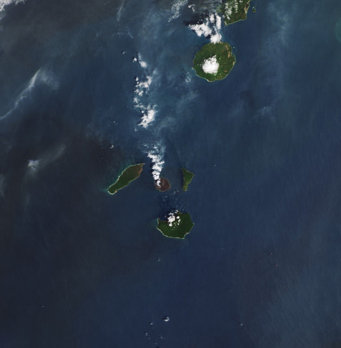
NASA satellite image of Anak Krakatau volcanic island in Indonesia's Sunda Strait

Why Volcanic Ash Can Stop Flights

Ash is not smoke — it is abrasive rock and glass.

Volcanic ash is not soft smoke. It is made of tiny, sharp particles of pulverized rock and volcanic glass. If an aircraft flies through a dense ash cloud, jet engines can be damaged or lose power, sensors can fail, and cockpit windshields can be scoured, badly reducing visibility. That is why airports and aviation authorities act cautiously the moment ash enters flight paths, even when the ground-level hazard is limited — the risk is highest thousands of meters up, exactly where aircraft cruise and climb.

This is also why the September 2026 Anak Krakatau event, despite carrying no confirmed tsunami risk, still forced Jakarta’s Soekarno-Hatta Airport to suspend 209 flights: the ash hazard and the tsunami hazard are evaluated separately, and one can be serious while the other is not.

Why the 2018 Tsunami Matters

The event that changed how Anak Krakatau is watched.

The 2018 disaster changed how people think about Anak Krakatau. It showed that the danger is not only explosive eruption — the shape and stability of the volcano’s flanks matter too. When a flank collapses into the sea, the displaced water can create a tsunami quickly, sometimes with little or no warning, because standard tsunami-detection systems are built around earthquakes, not sudden volcanic landslides.

That is the specific reason Indonesian authorities and international volcanologists still monitor Anak Krakatau’s flank stability closely alongside its eruption activity, even in years like 2026 when the confirmed hazard is ash rather than a repeat collapse.

⚠️ This Article Does Not Predict the Next Eruption

Volcanic activity can change quickly and unpredictably. This article describes confirmed past and current events, sourced to named outlets, agencies and peer-reviewed research. It does not forecast whether Anak Krakatau will erupt again, collapse again, or cause a future tsunami. For live conditions, always check Indonesia’s Geological Agency (PVMBG), MAGMA Indonesia, BNPB or BMKG rather than relying on any single article.

Explore More Timelines

People also ask

Is Krakatoa still active today?
The original 1883 Krakatoa island no longer exists in its pre-1883 form, but the volcanic system is very much active through Anak Krakatau, which has erupted repeatedly since 1927, including in 2018 and 2026.
What islands remain from the original Krakatoa?
Fragments of the pre-1883 island survive, principally the remnant known as Rakata, along with smaller islets such as Sertung and Panjang around the rim of the caldera the 1883 eruption created.
How does volcanic ash affect aviation safety generally?
Volcanic ash can damage jet engines, abrade windshields and disable sensors, so airlines and airports typically suspend flights or reroute around ash clouds identified through satellite tracking and volcanic ash advisory centers.
What’s the difference between Krakatoa’s 1883 explosion and a typical eruption?
The 1883 eruption was an unusually violent, caldera-collapsing event that destroyed most of an island and triggered major tsunamis, unlike the more moderate explosive and effusive eruptions Anak Krakatau has produced in recent decades.
Are there early-warning systems for volcanic tsunamis today?
Monitoring has improved since 2018, including closer tracking of volcanic deformation and seismicity, but volcanic flank-collapse tsunamis remain harder to detect in advance than earthquake-triggered tsunamis, which is why exclusion zones and rapid alerts remain the main defense.

Frequently asked questions

Direct answers on Krakatoa, Anak Krakatau and the 2018-2026 events — concise enough for quick reference.

What was the Krakatoa eruption?
The Krakatoa eruption was a catastrophic volcanic eruption in Indonesia’s Sunda Strait in August 1883. It destroyed much of the volcanic island and generated deadly tsunamis that struck the coasts of Java and Sumatra.
What is Anak Krakatau?
Anak Krakatau means “Child of Krakatoa.” It is a volcanic island that emerged from the sea in the caldera left by the 1883 Krakatoa eruption, first appearing in late 1927.
Did Anak Krakatau cause a tsunami in 2018?
Yes. A peer-reviewed study (Ye et al., 2020, Science Advances) links the 22 December 2018 Sunda Strait tsunami to a flank collapse of Anak Krakatau, when part of the volcano slid into the sea, killing 437 confirmed people according to Indonesia’s national disaster agency (BNPB).
Is the 2026 Anak Krakatau eruption causing a tsunami?
Current reports say authorities found no immediate tsunami threat from the September 2026 eruption. The main reported hazard was volcanic ash disrupting flights and local activity around Jakarta.
Why did Jakarta airport suspend flights?
Flights were suspended at Soekarno-Hatta International Airport because volcanic ash from Anak Krakatau affected the surrounding airspace. Ash can damage aircraft engines and create serious aviation safety risks, so 209 flights were affected according to Reuters.
Where is Krakatoa located?
Krakatoa, also spelled Krakatau, is in Indonesia’s Sunda Strait, the sea passage between the islands of Java and Sumatra.
Why is Krakatoa famous?
Krakatoa is famous because its 1883 eruption was one of the most violent and deadly volcanic events in recorded history, with global atmospheric effects, a sound heard thousands of kilometers away, and devastating tsunamis.
What is the difference between Krakatoa and Anak Krakatau?
Krakatoa refers to the older volcanic island system largely destroyed in the 1883 eruption. Anak Krakatau is the newer volcanic island that later grew from the same caldera, starting in late 1927.
When did the 1883 Krakatoa eruption happen?
The climactic eruption occurred over 26-27 August 1883, with the most violent explosion recorded on the morning of 27 August.
How many people died in the 1883 Krakatoa eruption?
The official Dutch colonial death toll was 36,417, according to NOAA’s historical record, with most deaths caused by tsunamis rather than the eruption itself.
How loud was the 1883 Krakatoa explosion?
The final explosion is considered the loudest sound in recorded history. NOAA notes it was reportedly heard over 4,600 kilometers away near Rodrigues Island in the Indian Ocean.
Did the 1883 eruption affect global climate?
Yes. Ash and sulfate aerosols from the eruption spread through the atmosphere, producing vivid sunsets worldwide for months and contributing to roughly half a degree Celsius of global cooling the following year.
What is a pyroclastic flow?
A pyroclastic flow is a fast-moving current of hot gas, ash and volcanic rock that flows down a volcano’s slopes during an explosive eruption, capable of destroying almost everything in its path.
When did Anak Krakatau first appear?
According to the Smithsonian Global Volcanism Program, Anak Krakatau first emerged from the sea in late 1927, inside the caldera left by the 1883 eruption.
How tall was Anak Krakatau before the 2018 collapse?
Anak Krakatau had grown to roughly 338 meters in height through more than 40 recorded eruptive episodes before the December 2018 flank collapse removed much of that height.
How many people died in the 2018 Anak Krakatau tsunami?
Indonesia’s national disaster agency (BNPB) confirmed 437 deaths from the 22 December 2018 tsunami, with thousands more injured along the Banten and Lampung coastlines.
Why wasn’t there a tsunami warning in 2018?
The tsunami was triggered by a volcanic flank collapse, not an earthquake, and Indonesia’s tsunami-detection network at the time was built around seismic triggers, so it did not detect the volcanic landslide in advance.
What causes a volcanic flank collapse?
A volcanic flank can collapse when a steep, eruption-built slope becomes structurally unstable under its own weight, sometimes triggered or worsened by ongoing eruptive activity, and gives way suddenly, especially when it borders the sea.
What is the Ring of Fire?
The Ring of Fire is a horseshoe-shaped zone around the Pacific Basin with intense volcanic and seismic activity. Indonesia, including the Sunda Strait volcanoes, sits along this belt, which is why the country has roughly 120 active volcanoes.
What is PVMBG?
PVMBG is Indonesia’s Center for Volcanology and Geological Hazard Mitigation, part of the country’s Geological Agency, responsible for monitoring volcanoes including Anak Krakatau and issuing official alert levels.
What do Indonesian volcano alert levels mean?
Indonesia uses a four-level scale: Level I (Normal), Level II (Waspada/Caution), Level III (Siaga/Alert) and Level IV (Awas/Danger), with each level tied to specific monitoring thresholds and exclusion-zone recommendations.
What alert level is Anak Krakatau at in 2026?
Indonesian authorities raised Anak Krakatau’s status to Level III (Siaga/Alert) on 2 July 2026 after a surge in volcanic earthquakes and deformation, with a 3km exclusion zone in place.
How big was the exclusion zone around Anak Krakatau in 2026?
A 3km exclusion zone was enforced following the July 2026 alert raise, smaller than the roughly 5km zone recommended immediately after the 2018 tsunami.
How is Anak Krakatau monitored today?
Indonesia’s Geological Agency monitors the volcano through seismographs, ground-deformation sensors and visual observation posts, with public updates issued through the MAGMA Indonesia platform and PVMBG bulletins.
Can volcanic ash damage an airplane?
Yes. Volcanic ash is made of abrasive rock and glass particles that can damage jet engines, scour windshields and interfere with sensors, which is why airlines suspend or reroute flights around ash clouds.
What altitude did the September 2026 ash plume reach?
Reuters reported ash plumes reaching roughly 6,000 meters (about 20,000 feet) over parts of Java and up to about 15,000 meters (50,000 feet) toward Sumatra and Banten during the September 2026 eruption.
How many flights were affected by the September 2026 eruption?
Reuters reported that 209 flights were affected at Jakarta’s Soekarno-Hatta International Airport due to ash from the September 2026 Anak Krakatau eruption.
Did the September 2026 eruption cause any deaths?
No deaths have been reported in connection with the September 2026 ash disruption; the confirmed impacts were flight suspensions, school activity cancellations and localized eye irritation from ash.
Is it safe to travel to Indonesia because of Anak Krakatau?
Most of Indonesia is unaffected by localized volcanic activity at Anak Krakatau; travelers should check flight status for Jakarta and follow official PVMBG/BNPB advisories rather than assuming risk based on this article alone.
What is the Sunda Strait?
The Sunda Strait is the narrow sea passage separating the Indonesian islands of Java and Sumatra, connecting the Java Sea to the Indian Ocean, and home to the Anak Krakatau volcanic island.
Is Anak Krakatau expected to erupt again?
Anak Krakatau has erupted repeatedly since 1927 and remains an active volcano under close monitoring, but this article does not predict a specific future eruption; check PVMBG for current status.
How do scientists study volcanic tsunami risk today?
Researchers combine satellite deformation data, seismic monitoring, undersea bathymetry surveys and computer modeling of potential flank failures, building on lessons from the 2018 Anak Krakatau collapse studied in Science Advances.

Related AiTimeline reading

⚠️ Editorial note & methodology

Author: The AI Timeline Editorial Team · Editor: AiTimeline Editorial · Last updated: 6 September 2026. Facts are drawn from Reuters reporting (via Jakarta Post/AP wire), Indonesia’s PVMBG/Geological Agency and BNPB, the Smithsonian Global Volcanism Program, NOAA’s historical eruption record, and the peer-reviewed 2018 flank-collapse study by Ye et al. (2020, Science Advances). This article is educational and editorial, not an official hazard alert; it does not predict future eruptions or guarantee any specific tsunami outcome. Corrections: corrections@aitimeline.in.

Advertisement
Global Bond Market Timeline 2008-2026: Bond Sell-Off, Yields and Debt Crisis Tariff Walls and Trade Bridges: The Hidden Forces Reshaping Global Trade
Next Article