Indonesia Wildfire Timeline 1997–2026: Why Peat Fires Keep Burning Underground
Indonesia wildfire timeline 1997-2026: verified 2026 hotspot and emissions data, why peatlands burn underground, and how it compares to the 2015 crisis.
Latest Story
Satellites can watch a fire from orbit. Yet some of Indonesia’s most dangerous fires can spread where no camera or sensor can easily follow — a few centimetres beneath the surface. Every dry season, farmers and plantation firms clear land on Sumatra and Kalimantan by burning it, and when that fire reaches drained tropical peat, it stops behaving like a normal forest fire. It sinks in, and it can smoulder for weeks. In 2026, Indonesia is going through its most intense fire season since 2015, driven by a strengthening El Niño, with real health, economic and regional consequences already unfolding. This Indonesia wildfire timeline traces the crisis from the catastrophic 1997–98 haze to the numbers coming in this week, and explains the one thing that makes Indonesia’s fires different from almost anywhere else: the ground itself is the fuel.
🧠 Quick Answer
Indonesia’s fires happen because land is deliberately cleared by burning, and when that fire reaches drained tropical peatland — deep, dried layers of ancient organic matter, mostly on Sumatra and Kalimantan — it can smoulder below the surface for weeks, resisting rain and surface firefighting. 2026 is Indonesia’s most intense fire season since 2015: BNPB and Copernicus data through 8–9 September 2026 show 13,443 hotspots since 1 August, fire emissions 273% above the seasonal average, and hazardous air quality in West Kalimantan, driven by a strengthening El Niño. It has not yet matched the scale of the full 2015 disaster, which burned 2.6 million hectares and was linked to roughly 100,300 premature deaths across Indonesia, Singapore and Malaysia.
Indonesia’s Fires: Key Questions
What this Indonesia wildfire timeline shows
- The fire is rarely the real problem — the ground is. Ordinary vegetation fires burn out in hours; a peat fire in the same spot can keep smouldering for weeks after the flames disappear.
- 2026 is real, but it is not (yet) 2015. Verified data through 8–9 September 2026 shows the most intense season since 2015 by several measures, but far below 2015’s eventual full-year scale.
- El Niño is the recurring trigger, not the root cause. Every major fire year on this timeline — 1997, 2006, 2015, and 2026 — lines up with a strong El Niño drought; the underlying vulnerability is decades of peatland drainage for agriculture.
- Indonesia’s own instruments already call 2026 conditions “very strong.” Global agencies like NOAA are more cautious, still tracking a “moderate-to-strong” event as of mid-2026 that is forecast to intensify through the year — a real, explainable disagreement between indices, not a contradiction.
- Post-2015 reforms are real, not cosmetic. The Peatland Restoration Agency, a nationwide moratorium on new peatland/primary-forest permits, and thousands of canal blocks measurably reduced fire risk on treated land.
- Reforms did not end the problem. Restoration only covers a fraction of Indonesia’s ~15 million hectares of peatland, and a strong enough drought can still overwhelm rewetted areas that dry out faster than expected.
- Satellites can miss the fires that matter most. Thermal sensors are built to catch heat, and a smouldering peat fire is often too cool, too shallow, or too shrouded in its own smoke to register as a hotspot.
- The regional haze is already back in 2026. As of early September, Malaysia’s Sarawak state declared an emergency, Singapore recorded “unhealthy” air, and Philippine cities briefly closed schools — smaller than 1997 or 2015, but real and current.
- Numbers from different sources rarely mean the same thing. A “hotspot,” a hectare burned, and a tonne of CO₂ emitted are three different measurements, and comparing them across sources without matching dates and definitions produces misleading conclusions.
- The fire season is not over. BMKG expects the critical dry-fire window to extend into September and October 2026, so every figure on this page is a snapshot, not a final total.
🔥 Indonesia Fire Season 2026 Tracker
Verified against BNPB, BMKG, Copernicus CAMS and IQAir. Figures can change as satellite detections and official assessments are updated.
How Can a Fire Burn Underground?
“Underground wildfire” is simplified reader-facing language for a real, well-documented process — oxygen-limited smouldering combustion in dried peat, not flames moving through a cavern
Start with the plain version: healthy tropical peat is essentially a waterlogged sponge of half-decomposed plants, built up over centuries. As long as the water table stays near the surface, that sponge cannot burn — there is no oxygen reaching the fuel.
Drain it — and Indonesia’s peatlands have been drained for decades, first for transmigration rice schemes, later for pulpwood and oil-palm plantations — and the top layers dry out. Dry peat is still mostly carbon, and now it has the one thing it was missing: air pockets. When a surface fire (almost always set deliberately, to clear land cheaply) reaches drained peat, it can ignite smouldering combustion: a slow, flameless burn similar to a cigarette ember, creeping through the dried peat at a fraction of a flaming fire’s speed but persisting far longer. It spreads sideways under vegetation and downward along root channels and cracks, which is the mechanism behind the “underground fire” people describe — not flames moving through open cavities, but combustion continuing where nobody can see it. This is why firefighters distinguish a peat fire from a normal wildfire, and why it demands a completely different response.
Set Fire to a Peatland
A short interactive walkthrough of why peat fires are so hard to finish off. Educational simulation, not a real-time model.
JavaScript is off, so here’s the short version: draining a peatland lowers its water table and dries the peat; a fire reaching that dry peat can smoulder below the surface; a rain shower usually kills the visible flame but not necessarily the deeper glow, which is why peat fires can resurface days or weeks later.
Timeline: Indonesia’s Fires, 1997–2026
Newest first — three decades of El Niño droughts meeting drained peatland
Most Intense Fire Season Since 2015, Driven by a Strengthening El Niño
What’s happening: BNPB has prioritised six provinces — Riau, Jambi, South Sumatra, South Kalimantan, Central Kalimantan and West Kalimantan — deploying over 39,000 personnel, helicopters and cloud seeding. Central Kalimantan alone saw hotspots jump by 1,837 in a single day to 3,947. Copernicus CAMS recorded 19.7 Mt of CO₂ emitted 1–7 September, 273% above the seasonal average; Pontianak’s air quality hit 394 on 9 September. Malaysia’s Sarawak state declared an emergency and closed roughly 650 schools; Singapore and parts of the Philippines also reported degraded air quality in early September.
Why it matters: Authorities call this Indonesia’s most intense fire season in 11 years — since 2015 — but “most intense since 2015” is not the same as “worse than 2015.” Full-year 2015 burned 2.6 million hectares; 2026’s confirmed burned area so far is a fraction of that, though estimates vary by source and the season is not over.
Restoration Continues, Moratorium Made Permanent, Fires Stay Smaller Than 2015 or 2019
What happened: The Peatland Restoration Agency merged with mangrove restoration in 2020 to form BRGM (Peat and Mangrove Restoration Agency) under Presidential Regulation No. 120/2020, widening its mandate. Indonesia’s moratorium on new permits to convert primary forest and peatland — renewed every few years since 2011 — was made permanent in 2019. Canal-blocking and rewetting work continued across the priority provinces.
Why it matters: Between the worst years, Indonesia’s fire seasons were smaller and shorter, which restoration researchers credit partly to rewetted peat and partly to wetter-than-average years — the two are hard to fully separate, and 2026 is the first real stress test of how durable those gains are under a strong El Niño.
A Dry Season Fire Crisis Returns, Smaller Than 2015 but Still Severe
What happened: A dry season without a major El Niño still produced widespread fires across Sumatra and Kalimantan, again sending haze into Malaysia and Singapore and prompting school closures in several Indonesian provinces.
Why it matters: 2019 showed the crisis does not require a record-breaking El Niño to recur — drained peatland stays flammable in almost any dry year, which is the core argument for restoration over crisis response alone.
2016
Indonesia Creates the Peatland Restoration Agency (BRG)
What happened: Following the 2015 disaster, President Joko Widodo established the Peatland Restoration Agency (Badan Restorasi Gambut, BRG) by presidential regulation, with a mandate to restore 2 million hectares of burned or degraded peatland within five years across seven priority provinces: Riau, Jambi, South Sumatra, West/Central/South Kalimantan and Papua.
Why it matters: This was Indonesia’s first dedicated, well-funded institution for peatland restoration rather than just fire suppression — rewetting (blocking drainage canals to raise the water table) rather than only fighting fires after ignition.
Indonesia’s Defining Modern Fire Disaster
What happened: A strong El Niño drought combined with drained peatland to produce Indonesia’s worst fire season since 1997. Fires burned an estimated 2.6 million hectares — an area bigger than Wales — concentrated on Sumatra, Kalimantan and Papua. On peak days, Indonesia’s daily emissions were estimated to have exceeded the entire United States economy’s daily output.
Why it matters: The World Bank put the direct economic cost at $16.1 billion, about 1.9% of Indonesia’s 2015 GDP. A peer-reviewed Harvard-Columbia study (Environmental Research Letters) estimated roughly 100,300 premature deaths from smoke exposure across the region — about 91,600 in Indonesia, 6,500 in Malaysia and 2,200 in Singapore. This is the benchmark every later fire season, including 2026, gets measured against.
Riau Fires Send Singapore’s Pollution Index to a Record High
What happened: Fires concentrated in Sumatra’s Riau province produced haze so severe that Singapore’s Pollutant Standards Index (PSI) hit a record 401 (hazardous) on 21 June 2013, its worst reading since records began.
Why it matters: 2013 shifted transboundary haze from a periodic irritant into a recurring diplomatic flashpoint between Indonesia, Singapore and Malaysia, and pushed all three toward tighter regional monitoring commitments.
A Weaker El Niño Still Reignites Severe Peat Fires
What happened: A moderate El Niño year still produced one of the more severe fire and haze episodes of the 2000s across Kalimantan, again driven largely by land-clearing fires on degraded peatland.
Why it matters: 2006 reinforced that Indonesia did not need a record El Niño to see a serious fire season — the peatland vulnerability created by decades of drainage was, by this point, doing most of the work.
98
The Great Haze: Indonesia’s First Modern Fire Catastrophe
What happened: A record-strength El Niño drought combined with aggressive land-clearing fires across Sumatra and Kalimantan to produce the region’s first modern transboundary haze crisis. Commonly cited estimates put the burned area at roughly 9.7 million hectares nationwide, with the resulting smoke blanketing Malaysia, Singapore and Brunei for months.
Why it matters: 1997–98 first exposed, at massive scale, how dangerous drained tropical peatland becomes during drought — and led directly to the 2002 ASEAN Agreement on Transboundary Haze Pollution, the region’s main haze-cooperation framework since.
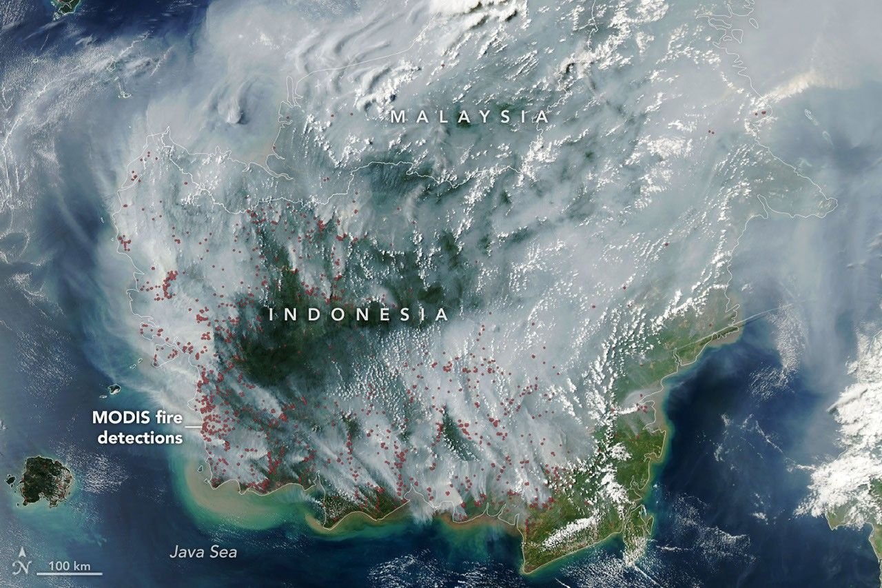
NASA Earth Observatory satellite imagery of fire detections (red dots) and smoke haze over Kalimantan and the Java Sea during a major Indonesian fire season. Source: NASA Earth Observatory (Terra/MODIS).
2015 vs 2026: What the Numbers Actually Show
Same crisis, different scale — and not yet a fair full-season comparison
| Metric | 2015 (full year) | 2026 (to 8–9 Sep) |
|---|---|---|
| ENSO status | Strong El Niño | El Niño, strengthening (BMKG: very strong; NOAA ONI: moderate, rising) |
| Hotspot period compared | Aug 1–Sep 8, 2015: 9,454 | Aug 1–Sep 8, 2026: 13,443 |
| Fire emissions, matched week | 21.7 Mt CO₂ (1–7 Sep) | 19.7 Mt CO₂ (1–7 Sep), 273% above seasonal average |
| Area burned | 2.6M hectares (full year) | ~202,000 ha Jan–Jul + estimated growth in Aug–Sep (exact YTD figure disputed between sources, see note) |
| Air pollution | Singapore PSI reached hazardous levels in multiple cities | Pontianak AQI 394 (hazardous); Singapore “unhealthy,” Sarawak emergency declared |
| Regions most affected | Sumatra, Kalimantan, Papua | Kalimantan, Sumatra, South Papua |
| Transboundary haze | Singapore, Malaysia, Brunei, Thailand affected for months | Sarawak (Malaysia), Singapore, parts of the Philippines affected in early September so far |
| Health/economic toll | $16.1B loss (1.9% GDP); ~100,300 estimated premature deaths | Not yet estimated; season ongoing |
| Period covered | Full calendar year | Year-to-date, season still active |
| Primary sources | World Bank, Harvard-Columbia study (Env. Research Letters) | BNPB, BMKG, Copernicus CAMS, IQAir |
Two figures in this table actually point the other way from what the headlines suggest: the matched-week emissions figure (19.7 Mt in 2026 vs 21.7 Mt in 2015) and the hotspot count in isolation both need context. 2026’s early-September week is intense but still slightly below the same week in 2015. What has genuinely jumped is the rate — 273% above the seasonal average is a measure of how unusual this week is for 2026 itself, not a direct size comparison to 2015. Authorities’ own framing — “most intense fire season in 11 years” — is the accurate read: worse than every year since 2015, not worse than 2015 itself, at least not yet.
On burned area, two credible outlets published different 2026 year-to-date figures within days of each other in early September — one estimate near 300,000 hectares, another combining a confirmed ~202,000 hectares (January–July) with a separate August estimate of roughly 600,000 hectares. The gap likely comes down to cutoff date and methodology (confirmed burn-scar mapping vs. hotspot-based estimation), not one source being wrong. We’re showing both rather than picking whichever number is larger.
Can Satellites Miss Underground Peat Fires?
Yes, sometimes — and that’s a real detection limitation, not a knock against satellite monitoring
Fire-detecting satellites like NASA’s FIRMS (using MODIS and VIIRS sensors) work by scanning for thermal anomalies — patches of ground that are hotter than their surroundings. That works well for large, hot, flaming fires. It works less well for a peat fire smouldering a few centimetres under the surface, cooled and shrouded by everything above it, or obscured entirely by the thick smoke its own burning produces.
Mark Parrington, a senior scientist at the Copernicus Atmosphere Monitoring Service (CAMS), put it plainly: “One of the aspects with peat fires is if they’re burning at low temperatures or underground, they’d be below the detection limit of the sensors, which means we’re not actually seeing them.” That doesn’t mean satellites are useless — CAMS’ own emissions estimates, built from a mix of satellite fire radiative power and smoke-plume modelling, are exactly how outlets tracked the 19.7 Mt figure above. It means hotspot counts alone likely understate the true extent of a peat fire season, which is one reason officials increasingly report emissions and burned-area estimates alongside hotspot counts, not instead of them.
The Carbon Stored Beneath the Ground
Why a peat fire is a climate story, not just a local disaster
Indonesia’s peatlands are estimated to store somewhere between 13.6 and 40.5 gigatonnes of carbon, with a widely cited best estimate around 28.1 gigatonnes (Warren et al., Carbon Balance and Management, 2017, based on national peatland maps) — roughly 30% more carbon than sits in the biomass of all of Indonesia’s forests combined, and part of a global tropical peat carbon pool the same study puts near 75 gigatonnes. That carbon accumulated over centuries because waterlogged peat barely decomposes. Drain it and burn it, and that slow accumulation reverses in weeks, which is the real reason a peat fire matters far beyond the smoke it produces locally.
Southeast Asia’s Regional Haze, 2026
What “transboundary haze” means, and what’s actually confirmed as of early September 2026
What is transboundary haze?
Transboundary haze is smoke pollution from land and forest fires that crosses national borders on prevailing winds, most often from Sumatra and Kalimantan toward Peninsular Malaysia, Singapore and, in wider events, further into the Philippines. It is governed regionally by the 2002 ASEAN Agreement on Transboundary Haze Pollution, and monitored jointly through the ASEAN Specialised Meteorological Centre.
Sarawak, Malaysia
Emergency declared; around 650 schools closed as smoke drifted from nearby Kalimantan fires on the same island of Borneo. Source: AFP, 5 September 2026.
Singapore
Air quality in the central region reached “unhealthy” levels on a single reported day; not (as of writing) a sustained multi-week event like 2013 or 2015. Source: AFP, 5 September 2026.
Philippines
Some cities and provinces saw roughly a week of very-to-severely-unhealthy PM2.5 and briefly closed schools; conditions were reported improving toward normal by the article date. Source: AFP, 5 September 2026.
Kalimantan & Sumatra
More than 5 million people directly exposed to health risk, and over 1.4 million students shifted to remote learning as of early September 2026. Source: AFP, 5 September 2026.
One more data point keeps this in perspective: NASA estimated that, as of 2 September 2026, Indonesia’s 2026 fires had cumulatively released roughly 10% as much carbon as the entire 2015 season. Even during an unusually intense few weeks, the season is still early relative to 2015’s eventual scale.
This is meaningfully smaller than 1997 or 2015, when haze blanketed the region for months and grounded flights across multiple countries for extended periods — but it is real, current, and tracks the same wind pattern (Sumatra fires toward the Malacca Strait and Singapore; Kalimantan fires toward the rest of Borneo, including Sarawak, and outward toward the Philippines in wider events).
Explore More Timelines
What Changed After 2015 — and Why the Problem Can Still Return
Real reforms, real limits
Indonesia’s response to 2015 was not cosmetic. The Peatland Restoration Agency (BRG), created by presidential regulation on 6 January 2016, was given a specific, measurable target: restore 2 million hectares of burned or degraded peatland within five years, mainly by rewetting — blocking drainage canals so the water table rises back toward the surface, plus revegetation and community-based fire prevention in the same priority provinces. In 2019, Indonesia made its moratorium on new permits to clear primary forest and peatland permanent rather than renewing it every few years. In 2020, BRG merged with a mangrove-restoration mandate to become BRGM, widening its scope.
Between 2016 and 2025, fire seasons were, on the whole, smaller than 1997, 2006 or 2015 — though separating the effect of restoration from the effect of several relatively wetter years in between is genuinely difficult, and independent researchers have flagged that as an open question rather than a settled win.
So why can severe peat fires still return?
- Restoration covers a fraction of the problem. Indonesia has an estimated 15 million-plus hectares of peatland; a 2-million-hectare restoration target, even if fully met, leaves most peatland outside the program untouched or only partially rewetted.
- Rewetted peat can still dry out. A strong enough drought, like the one building through 2026, lowers water tables faster than canal-blocking alone can compensate, especially at the edges of restored zones.
- Ignition is still overwhelmingly human. Restoration changes how flammable the land is, not whether someone sets a fire on it — enforcement against illegal burning remains uneven, especially on smallholder and disputed land.
- El Niño keeps returning on its own schedule. Restoration is a multi-decade project; El Niño droughts arrive every few years regardless of how that project is progressing, and 2026 is the first genuinely strong test since the reforms began.
The honest reading of 2026, based on verified data so far, is that the reforms are working as intended — slowing the crisis, not eliminating it — against a strengthening El Niño that is exactly the kind of stress test they were never going to fully survive untested.
🔍 How We Track Indonesia’s Fires
- Hotspots come from satellite thermal-anomaly detection (NASA FIRMS via MODIS/VIIRS, mirrored on Indonesia’s own Sipongi platform) and count individual detections, not fires or area — one large fire can register many hotspots, and one smouldering peat fire may register none.
- Burned area is either mapped from burn-scar satellite imagery after the fact or estimated in near-real-time from hotspot density — the two methods can disagree, especially mid-season, which is why 2026 area estimates vary between sources.
- Fire emissions (tonnes of CO₂) come from Copernicus CAMS’ Global Fire Assimilation System, which combines satellite-observed fire radiative power with atmospheric modelling — this can catch some fires that hotspot counts miss.
- Air quality (AQI/PSI) is measured at ground-level monitoring stations (IQAir, national agencies) and reflects local particulate concentration, not the fires themselves — wind direction matters as much as fire size.
- Because these are different instruments measuring different things, on different schedules, from different agencies, small disagreements between sources are normal and do not mean one source is wrong.
Frequently Asked Questions
Related AiTimeline Stories
Sources & further reading
Every dated entry above was checked against these references. Last reviewed 15 September 2026.
- BMKG — El Nino Sangat Kuat, Sumatra-Papua Masih Kritis (Sept 8, 2026)
- NASA Earth Observatory — Peatland Fires Darken Skies in Indonesia
- The World Bank — The Cost of Fire: An Economic Analysis of Indonesia's 2015 Fire Crisis
- Nature — The Amount of Carbon Released from Peat and Forest Fires in Indonesia During 1997 (Page et al., 2002)
- NOAA Climate Prediction Center — ENSO Diagnostic Discussion
- Reuters via Free Malaysia Today — Indonesian Wildfire Emissions Surge to World's Highest (Sept 9, 2026)
- ASEAN Specialised Meteorological Centre — Regional Haze Situation
- CIFOR-ICRAF Forests News — Progress and Perils in Indonesia's Peatland Restoration Journey