Himalayan Hydropower Timeline 1960–2026: India, Nepal, Dams and Flood Risks
The Himalayas hold vast hydropower potential, but dams, tunnels and power projects now face rising risks from fragile geology, glacier floods, landslides
Latest Story
The Himalayas could power millions of homes across India, Nepal and the wider region — their rivers carry some of the steepest, fastest-flowing water on Earth. But the same mountains are young, seismically active and increasingly exposed to glacier collapse and extreme rain. This Himalayan hydropower timeline runs from the 1960 Indus Waters Treaty through India’s 2003 hydro push, Nepal’s export ambitions, the October 2023 destruction of Teesta III, and the catastrophic August 2026 Nepal–Tibet glacier-collapse flood. It is a record of energy promise colliding with mountain geology — not an argument against dams.
🧠 Quick Answer — Why Are Himalayan Hydropower Projects Becoming Riskier?
Himalayan hydropower projects are becoming riskier because dams, tunnels, roads and transmission lines are being built in young, fragile mountains exposed to earthquakes, landslides, cloudbursts, glacial lake outburst floods and debris flows. Hydropower remains important for clean electricity and regional trade, especially between India and Nepal, but recent disasters show that engineering, insurance and emergency planning must account for faster-moving mountain hazards.
What the Himalayan Hydropower Story Really Shows
- Himalayan hydropower can provide major clean electricity for India, Nepal and neighbouring regions — the mountains’ steep gradients and fast rivers make them some of the most energy-dense hydro terrain on Earth.
- The 1960 Indus Waters Treaty shaped dam-building rules in the western Himalayas, dividing river rights between India and Pakistan and constraining how India can build hydropower on the Indus, Jhelum and Chenab.
- India’s 2003 50,000 MW hydro initiative identified 162 projects across 16 states, with more than half the capacity concentrated in Arunachal Pradesh, according to Ministry of Power records.
- Nepal and India signed a long-term agreement in January 2024 for Nepal to export 10,000 MW of electricity to India over 10 years — a 25-year pact with automatic renewal.
- The 1,200 MW Teesta III project in Sikkim was destroyed by the October 2023 South Lhonak glacial lake outburst flood, one of the most-studied GLOF disasters in Himalayan history.
- The August 2026 Nepal–Tibet glacier-collapse flood damaged roads, villages and power projects across both countries, trapping hundreds of hydropower workers in tunnels and knocking hundreds of megawatts off Nepal’s national grid.
- Run-of-river projects reduce some reservoir impacts, but tunnels, blasting, muck disposal and landslide exposure create their own, separate risks.
- The future of Himalayan hydropower depends on better hazard mapping, dam safety, early warning systems and cross-border coordination — not on choosing between energy and climate.
Himalayan Hydropower: Key Questions
Himalayan Hydropower Timeline: 1960–2026
Newest first — from the 2026 Nepal–Tibet flood back to the Indus Waters Treaty
Nepal–Tibet Glacier Collapse Exposes Infrastructure Risk
What happened: A roughly 0.2 sq km section of the Langtang Lirung glacier broke away at about 5,200 metres and fell some 1,200 metres onto the valley floor, triggering a massive ice-rock-debris flow that struck river systems on both sides of the Nepal–China border near the Rasuwagadhi crossing, moving at an estimated 50 metres per second.
Toll: According to Nepal’s National Disaster Risk Reduction and Management Authority, as of September 4, 2026 the disaster had killed at least 1,287 people in Nepal with 5,083 still missing and more than 5,300 injured; Chinese state media reported 31 deaths and 531 missing on the Tibet side. Reuters and AP reported that over 900 hydropower workers were missing across roughly a dozen projects at the peak of the crisis, including hundreds trapped in tunnels at the Upper Trishuli-1 project.
Infrastructure impact: The flood destroyed the 14.1 MW Devighat plant, damaged the Upper Trishuli-1, Upper Trishuli 3A, Rasuwagadhi and Chilime projects, and washed away a transmission hub, together taking roughly 431 MW of operating hydropower capacity offline and damaging a further ~470 MW under construction — close to 10 percent of Nepal’s installed power capacity, according to Reuters and Fortune reporting citing Nepali energy officials.
Nepal’s Hydropower Export Story Accelerates
What happened: Following the January 2024 trade pact, India steadily raised its seasonal imports of Nepali hydropower, reaching close to 1,000 MW by August 2024 during the monsoon surplus period, according to the Kathmandu Post. Nepal’s hydropower sector became increasingly tied to Indian demand through power-purchase agreements and expanded cross-border transmission lines.
Why it mattered: For a country that faced chronic winter load-shedding within the past decade, becoming a seasonal power exporter marked a genuine shift — but it also meant Nepal’s energy economy grew more dependent on a single buyer and on infrastructure sitting in some of the country’s most landslide- and flood-prone valleys.
India and Nepal Sign 10,000 MW Power Trade Agreement
What happened: India and Nepal signed a long-term power trade agreement in Kathmandu, committing Nepal to export 10,000 MW of hydroelectricity to India over the next 10 years under a 25-year deal that auto-renews. The agreement built on an understanding reached during Nepal PM Pushpa Kamal Dahal’s May–June 2023 visit to India.
Why it mattered: The deal marked Nepal’s shift from a country associated with chronic power shortages to one positioning itself as a regional clean-electricity exporter, while giving India access to seasonal, low-carbon hydropower to help meet peak and monsoon demand.
Teesta III Collapse Becomes a Turning Point
What happened: About 14.7 million cubic metres of frozen moraine collapsed into Sikkim’s South Lhonak glacial lake, generating a 20-metre displacement wave that breached the lake’s frontal moraine wall and released roughly 50 million cubic metres of water in a flash flood that struck the 1,200 MW Teesta III dam at Chungthang at around 00:30 on October 4, destroying the 60-metre-high structure.
Toll: A peer-reviewed study in the journal Science documented 129 deaths (55 confirmed, 74 missing), more than 25,900 buildings damaged or destroyed, 31 major bridges lost, and damage extending 385 km down the Teesta valley.
Why it mattered: Teesta III became the reference case for glacial lake risk to large Himalayan infrastructure — a fully built, operating 1,200 MW dam destroyed in a single night by a hazard that originated more than 60 km upstream, in a lake most residents downstream had never heard of.
China’s Lower Yarlung Tsangpo Super-Dam Plan Enters the Spotlight
What happened: China’s 14th Five-Year Plan (2021–2025) included hydropower development on the lower reaches of the Yarlung Tsangpo, the river that becomes the Brahmaputra downstream in India and Bangladesh. Reported proposals at the time discussed capacity in the tens of gigawatts, though no final project scope had been confirmed.
What followed: China’s government formally approved construction of the Medog hydropower project in December 2024, and Premier Li Qiang presided over a groundbreaking ceremony in Nyingchi on July 19, 2025. As reported, the project comprises five cascade dams with a combined installed capacity of roughly 60 GW and an estimated cost exceeding $137 billion, with commercial operations targeted for 2033 — figures that remain subject to revision as construction proceeds.
Why it mattered: Because the Yarlung Tsangpo becomes the Brahmaputra in India’s Arunachal Pradesh and Assam before flowing into Bangladesh, any major upstream dam raises questions in New Delhi and Dhaka about water flow data, transparency and strategic leverage, regardless of the project’s stated run-of-river design.
China Operates Zangmu Dam on the Yarlung Tsangpo
What happened: China commissioned the first generating unit of the 510 MW Zangmu Dam in Tibet, the first large-scale hydropower station on the main stem of the Yarlung Tsangpo, with the full plant completing commissioning in October 2015.
Why it mattered: Zangmu was the first concrete evidence that China intended to dam the Yarlung Tsangpo’s main channel, not just its tributaries. It raised early concern in India over upstream development on a river India depends on downstream, and over the limited flow and construction data China shares with lower-riparian states.
Tehri Dam Becomes a Himalayan Megaproject Symbol
What happened: After decades of surveys, funding delays and sustained local protest dating to the 1970s, the first 1,000 MW stage of the Tehri Dam on the Bhagirathi river in Uttarakhand was commissioned. The 260-metre rock and earthfill dam remains one of the tallest of its kind in the world.
Why it mattered: Tehri became a symbol of both what Himalayan hydropower could deliver — grid-scale electricity and irrigation water for northern India — and of the long-running debates over seismic risk in a high-hazard zone, displacement of Old Tehri town’s population, and downstream river ecology that still shape how new Himalayan dams are reviewed today.
India’s 50,000 MW Hydro Initiative
What happened: India’s government launched the 50,000 MW Hydroelectric Initiative, identifying 162 potential projects across 16 states with a combined capacity exceeding 50,000 MW, according to Ministry of Power and PIB records. Arunachal Pradesh, Uttarakhand and Himachal Pradesh emerged as the most important Himalayan focus areas, with Arunachal Pradesh alone accounting for 42 projects and more than half the identified capacity.
Why it mattered: The initiative reframed Himalayan rivers as a strategic national power resource at a scale far beyond individual projects like Tehri, setting the template — and much of the project pipeline — that still shapes India’s Himalayan hydropower ambitions two decades later.
Himalayan Dams Become Development Symbols
What happened: Dams and hydropower projects across the Himalayan states were promoted as tools for electrification, irrigation and flood control, and as visible symbols of post-independence national development. Early public debate centred mainly on power output, jobs and regional growth.
Why it mattered: Ecological and displacement concerns grew more prominent later in this period — most visibly through the Tehri Bandh Virodhi Sangharsh Samiti’s protests from 1978 onward — establishing a pattern of grassroots resistance that has accompanied nearly every major Himalayan dam proposed since.
Indus Waters Treaty Sets the Legal Frame
What happened: India and Pakistan signed the Indus Waters Treaty, brokered by the World Bank, dividing rights over the Indus basin’s six rivers — the three eastern rivers (Ravi, Beas, Sutlej) allocated largely to India, and the three western rivers (Indus, Jhelum, Chenab) allocated largely to Pakistan, with India permitted specific run-of-river hydropower uses on the western rivers under defined design constraints.
Why it mattered: The treaty became the legal frame for every major Indian hydropower project built since on the western Himalayan rivers, shaping design choices — run-of-river rather than large storage, specific spillway and pondage limits — for projects from Jammu and Kashmir through Himachal Pradesh.
2026 and Beyond: The Himalayan Hydropower Reality Check
The choice ahead is not “hydropower versus climate.” Both India and Nepal have strong reasons to keep building: clean electricity demand is rising, Nepal’s export revenue depends on it, and regional grids increasingly rely on Himalayan hydropower to balance seasonal and peak load. The real question is narrower and harder: can governments, developers and financiers design and site projects for mountain hazards that are becoming faster-moving and harder to ignore — glacial lake outburst floods, landslides, earthquakes, cloudbursts, sediment loads and tunnel collapse — rather than for the calmer river regimes many of these projects were originally designed around.
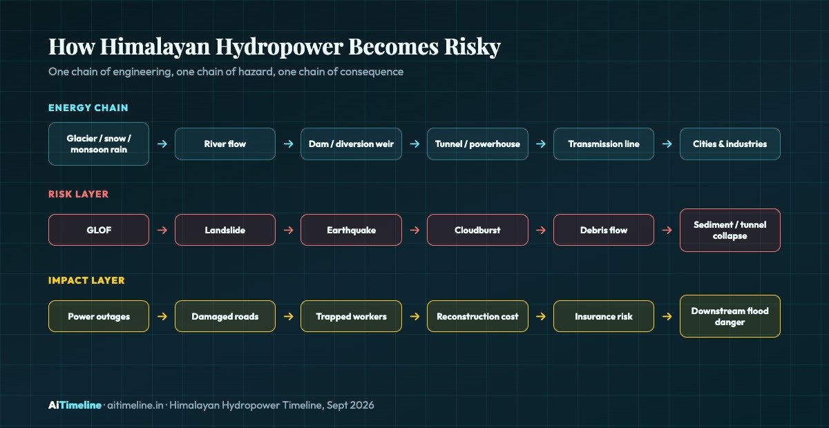
How Himalayan Hydropower Becomes Risky
The same basic chain, and the hazards layered onto it, repeat across nearly every major incident in this timeline
Glacial Lakes
Lakes formed behind unstable ice or moraine walls can release tens of millions of cubic metres of water in hours, as South Lhonak lake did in 2023.
Glacier Collapse
A rock-ice avalanche can trigger a fast debris flow even without a classic lake outburst, as seen at Langtang Lirung in August 2026.
Diversion Tunnels
Long tunnels carry river water to powerhouses through blasted rock — efficient for power generation, but a deadly trap if debris seals the entrance during a flood.
Transmission Lines
Lines and substations near river valleys are frequently the first assets lost, cutting power far beyond the immediate disaster zone.
Early Warning Systems
Sensors built for seasonal monsoon floods have repeatedly failed to detect faster, less predictable glacier-collapse events in time.
Hazard Mapping
Identifying which glacial lakes and slopes pose the greatest risk to existing and planned projects is now central to Himalayan hydropower planning.
India and Nepal: From Load-Shedding to Power Trade
- Nepal has large hydropower potential but historically faced electricity shortages and underinvestment, including years of scheduled winter load-shedding.
- India is the major nearby electricity market, with grid connections and demand large enough to absorb Nepal’s seasonal surplus.
- The January 2024 deal targets 10,000 MW of Nepal electricity exports to India over 10 years, under a 25-year auto-renewing agreement.
- This can help Nepal earn export revenue and help India buy cleaner peak and seasonal power to support its own clean-energy targets.
- Cross-border transmission capacity, pricing mechanisms, project finance and disaster resilience remain key open challenges on both sides.
For Nepal, hydropower is not just electricity; it is export revenue, infrastructure, diplomacy and national ambition, built around the idea that its rivers can do for the country’s economy what its geography has long denied it in manufacturing or trade access. For India, Nepal’s hydropower can support clean-energy goals and regional influence, offering a lower-carbon alternative to some domestic peaking capacity. But every new project also increases the need for cross-border early warning systems and transparent river-data sharing — without which one country’s dam failure or flood becomes the other’s blackout.
The New Risk: Glaciers, GLOFs and Debris Floods
- A GLOF happens when water stored in or behind a glacial lake suddenly releases, often because an ice or moraine wall fails.
- A glacier collapse or rock-ice avalanche can trigger a fast debris flow even without a classic lake outburst, as happened at Langtang Lirung in August 2026.
- These flows can carry boulders, ice, mud and trees at destructive speed — the 2026 Nepal event moved at an estimated 50 metres per second, or roughly 180 km/h.
- Dams, tunnels, bridges and roads built in narrow valleys can be hit with very little warning, since these events can outrun monsoon-flood-calibrated sensor networks.
- Early warning systems, hazard mapping and emergency drills are now central to how new and existing Himalayan hydropower projects are planned and insured.
Run-of-River Dams Were Supposed to Be Safer. Are They?
Run-of-river projects often avoid the huge reservoirs associated with large storage dams like Tehri, so they can reduce some forms of displacement and reservoir-related ecological impact. But they are not risk-free. Many Himalayan run-of-river projects require long tunnels bored through unstable rock, steep access roads cut into landslide-prone slopes, repeated blasting that can destabilise surrounding terrain, and muck-disposal sites that themselves become sources of debris during heavy rain.
The 2021 Chamoli disaster illustrated the pattern directly: a rock-and-ice avalanche on Nanda Devi triggered a flash flood that obliterated a 13.2 MW run-of-river plant and severely damaged the larger Tapovan-Vishnugad project, killing more than 200 people, many of them workers trapped inside the tunnel system. The August 2026 Nepal floods repeated the same failure mode at far larger scale, trapping hundreds of workers in the Upper Trishuli-1 tunnel and damaging several other run-of-river projects along the Trishuli system.
The honest answer is that run-of-river design solves one problem — large-reservoir displacement and ecological disruption — while leaving a different set of risks largely unaddressed: tunnel access, workforce safety during a fast-moving flood, and exposure to landslide and debris-flow paths that a smaller footprint does not remove. Safer siting, real-time monitoring of upstream glacial lakes, and tunnel evacuation protocols matter as much as the reservoir-versus-run-of-river choice itself.
Cross-Border Water Politics: Who Controls the Rivers?
Himalayan rivers do not respect borders, and neither do the risks and benefits of damming them. The Indus Waters Treaty remains the most formal water-sharing arrangement in the region, but no comparable binding treaty governs the Brahmaputra/Yarlung Tsangpo basin shared by China, India and Bangladesh. China has historically shared limited hydrological data with downstream India, and its December 2024 approval of the roughly 60 GW Medog project on the lower Yarlung Tsangpo — construction of which began in July 2025 — has intensified Indian and Bangladeshi concern over upstream control, even though the project is presented as run-of-river with limited storage.
Nepal sits in a different position: as a hydropower-rich, capital-constrained country between two larger neighbours, it has leaned into cooperative power trade with India rather than confrontation, while also exploring transmission access toward Bangladesh where grid connections and commercial terms allow. The unresolved thread across all these relationships is transparency — real-time river flow data, glacial lake monitoring, and dam-safety information shared across borders would let downstream communities and grid operators respond faster to both floods and outages, but no regional mechanism currently guarantees it.
🧠 Short Answer: What Is the Future of Himalayan Hydropower?
Himalayan hydropower’s future depends on treating mountain hazards as a core engineering input, not an afterthought. India, Nepal and China are all still expanding hydropower capacity because the underlying energy case remains strong, but the 2023 Teesta III collapse and 2026 Nepal-Tibet flood have shown that glacial lake monitoring, tunnel safety, early warning systems and cross-border data-sharing now matter as much as turbine capacity in deciding which projects succeed.
Explore More Timelines
People Also Ask
Frequently Asked Questions
Explore More on AiTimeline
⚠️ Editorial Note
This article separates verified figures from official and scientific sources (PIB, Ministry of Power, Indus Waters Treaty text, the journal Science, Reuters, AP, Al Jazeera, ICIMOD) from general background context, and avoids attributing any single disaster to a single cause without qualification. Casualty figures, capacity figures and cost estimates for the August 2026 Nepal-Tibet floods were still being revised by authorities at the time of writing and may be updated. This is editorial content, not engineering, safety or investment advice.
Sources & further reading
Every dated entry above was checked against these references. Last reviewed 15 September 2026.
- Ministry of Power, Government of India - 50,000 MW Hydroelectric Initiative
- PMO India - PM's speech at launch of 50,000 MW Hydroelectric Initiative
- Science - The Sikkim flood of October 2023: Drivers, causes, and impacts of a multihazard cascade
- Kathmandu Post - Nepal signs deal with India to export 10,000 MW power
- Wikipedia - 2026 Nepal-Tibet floods
- Fortune - Nepal floods knock 10% of power capacity offline
- Al Jazeera - Nepal tunnel traps hinder flood rescue
- Wikipedia - Zangmu Dam
- The Diplomat - What's Driving China's Mega Medog Hydropower Project?
- Wikipedia - Tehri Dam